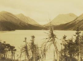
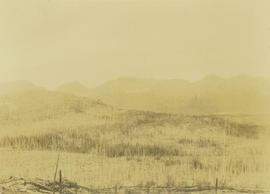
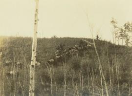
Photograph depicts a pack horse train walking down a grassy hill with a sparse tree line in the foreground.
Photograph of a large waterfront factory. Annotation on recto reads: "Pacific Mills, Ocean Falls, BC. No. 2935."
Photograph depicts an overview of a burned landscape with barren trees covering a plateau with mountains in the background.
Overhead photograph of Giscome buildings with Eaglet Creek running through the foreground. Handwritten annotation in pen on verso reads: “Notice the flatness of the land. Part of our community.”
Overhead photograph of Giscome with the Eagle Lake Sawmill's beehive burner clearly visible in left foreground. Handwritten annotation in pen on verso reads: “Part of our community. school * ”
Photographic overview of the Eagle Lake Sawmill. Handwritten annotation in pen on verso reads: “The mill.”
Photograph of various plant life with Eagle Lake visible in the background. Handwritten annotation in pen on verso reads: “Eagle Lake from the top of the bluff. Eagle Lake is about 7 miles long & about 1 mile wide. It is a fair sized lake.”
Photograph depicts an overview of an old burn site with burnt trees lining a hillside.
Slightly overhead shot of a large crowd gathered by general store and railroad. Annotation on recto reads: "Overseas contingent leaving Prince Rupert BC Feb 26th 1915. McRae Bros."
Wide angle photograph of many buildings scattered in a clear cut area. Foreground shows several businesses, including "Kelly Carruther's Supply" and "Prince Rupert Hardware and Supply Co." Some remaining forest is visible in the background. Annotation on recto reads: "Prince Rupert, BC 1659."
Image depicts a view over Tabor Mountain.
Image depicts what is likely an outhouse at Island Cache.
Photograph of several vessels within Victoria's outer wharf. Annotation on recto reads: "Empire Series. Outer Wharf, Victoria, BC."
Photograph depicts a shallow creek winding through dirt area, forest in background. Handwritten annotation on verso of photograph: "Otter Creek Showing overlying moraine 6/6/37". See also item 2009.5.2.69.
Image depicts the north aspect of Oscar Peak overlooking Lava Lake in the Nass Valley.
Image depicts an old road through the trees near Yellowhead Pass. The slide labels it as the origin of the Yellowhead highway.
Image depicts water flowing through an irrigation channel in an orchard, somewhere in or near Seton Portage, B.C. There is a sign which reads: "Danger Keep out."
Image depicts water flowing through an irrigation channel in an orchard, somewhere in or near Seton Portage, B.C.
Image depicts an open mining pit at an uncertain location; it is possibly Gibraltar.
Image depicts a field in Giscome, B.C. On the right side of the image, in the background, is a grey strip that appears to be a mine, possibly the quarry at Eaglet Lake in Giscome, B.C. Map coordinates 54°03'52.9"N 122°22'10.0"W
Image depicts an open field and Giscome, B.C. in the background. Map coordinates 54°03'52.9"N 122°22'10.0"W
Image depicts an open field and numerous buildings, including a church in Giscome, B.C. Map coordinates 54°04'03.2"N 122°22'04.6"W
Photograph depicts Onion Lake as seen through a barren tree line. In the background a mountain range surrounds the shores of the lake.
Image depicts a lake somewhere along what is possibly the Atlin Road to Atlin, B.C.
Front view of two men sitting on a pile of supplies with a mountain in the background. Printed annotation on recto reads: "On the Divide Enroute to Naas #96."
Image depicts a cabin on the "west arm" of Takla Lake.
Image depicts the "west arm" of Takla Lake.
Image depicts the "north-west arm" of Takla lake.
Image depicts a mountain and Takla Lake.
Image depicts a view of Takla Lake, "looking south-east."
Image depicts a view of Takla Lake, "looking north-west."
Image depicts a view of Takla Lake.
Image depicts several individuals walking on a trail somewhere near Raven Peak.
Image depicts four individuals canoeing on Lanezi Lake.
Image depicts two individuals canoeing on Lanezi Lake.
Image depicts an unknown individual in a canoe on Indianpoint Lake.
Image depicts Haida Gwaii.
Image depicts a bridge over the Omineca River near Germansen Landing, B.C.
Image depicts an old trestle along the White Pass railway.
Image depicts an old trestle along the White Pass railway, and the White pass Train on the left of the image.
Image depicts an old slump type of landslide. The slide labels it as being near "McAlister."
Image decpicts the old road to the townsite in Giscome, B.C. Map coordinates 54°04'19.7"N 122°22'04.7"W