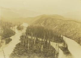
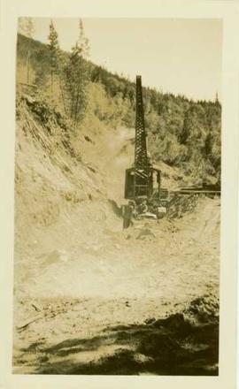
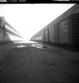
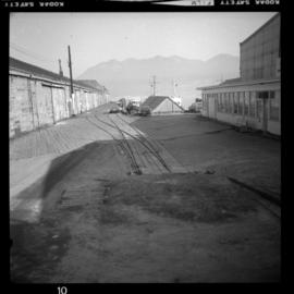
Photograph depicts the pit head refuse at Extension Coal Mine, 5 miles southwest of Nanaimo. It worked between 1901 and 1931.
Photograph depicts a portion of the pit in foreground at the Cassiar mine. Crushing plant visible in centre below base of West peak. Footwall road in midground, mine valley in background. Building near trucks at top of pit was called the "shifter shack," where crews were relieved or dropped off for work.
Photograph taken at Terrace Gardens.
Photograph depicts a landscape perspective of Germansen Placers including the pipeline.
Image depicts a pipeline at Shelley, B.C.
Photograph depicts a pipe yard of West Coast Gas Transmission. Two large pipes had gotten away and rolled onto the railway.
Photograph depicts Pioneer Sash and Door Company Ltd. Davies suggests that it may have been the same as S.C. Smith Ltd., which commenced operating in Vernon in 1883. In the early days, products were verandah posters, balusters, and fancy trim. Most products were sent to the U.S. Most of the fancy trim in early north Okanagan homes came from this plant. In 1972, its main output was cedar panelling for Florida.
Photograph is one of 13 images printed from digital format on a CD-R featuring members of a group referred to as 'Terracites' (see item 2009.6.1.697) pictured in the gardens; see also items 2009.6.1.698 - 2009.6.1.710.
Image depicts an old Swedish style house somewhere in the Pineview subdivision in Prince George, B.C.
Image depicts an old barn somewhere in the Pineview subdivision in Prince George, B.C.
Image depicts Pineview on Buckhorn Lake Road, Prince George, B.C.
Image depicts what is either the Peace or Kiskatinaw River in Pine Valley, B.C.
Image depicts the Pine Tree Restaurant in Atlin, B.C. It is possibly part of the Atlin Museum.
Photograph depicts Pine River winding between forested hillsides. Several islands covered with trees are located in the middle of Pine River. The river leads to Kinuseo Falls also known as Kinoosao Falls.
Image depicts a view of Pine Pass.
Image depicts a view of what is possibly the Pine Pass located near the Murray Ridge.
Image depicts an unidentified individual standing near a drop-off in the Pine Pass between Alberta and British Columbia. The sign behind the individual reads: "Pine Pass - 2,868 FT. Here the great barrier of the Rock Mountains is breached by the lowest highway pass. Once the remote route of the trapper, it now links the commerce of the north and markets of the south. The John Hart Highway was completed in 1952 and followed by the P.G.E. in 1958. Gas and oil lines also take advantage of this convenient natural feature."
Photograph depicts Pine Creek winding through forest and hills. Altin Lake and mountains in background. Handwritten annotation on recto of photograph: "Atlin: Looking down lower Pine Ck, westerly towards Atlin, Atlin Lk, & the Atlin Mts. (part of Coast Range)."
Image depicts an aerial view of Pine Centre Mall and Masich Place Stadium in Prince George, B.C.
Image depicts Pine Centre Mall in Prince George, B. C. Map coordinates 53°53'53.2"N 122°46'36.4"W
Photograph depicts the Pinchi Lake mercury mine as seen from the water. Some buildings appear to be under construction. Handwritten annotation on verso reads: "Pinchi Lake min (mercury).
Item is a photograph of Pilot Mountain School.
Item is a photograph of Pilot Mountain School taken from the back
Photograph depicts a wooden pile trestle that leads through a wooded landscape. Annotation on recto of photograph reads: "Pile tressle upper end. Sec.#1. Bents 12" centers - 3 only 12" piled driven to refusal; caps 10" x 12" "
Photograph depicts a two men standing on piles of whale bones at a whaling station. Annotation on verso of photograph states: "Pile of whale bones, Whaling station, Vancouver Is."
Image depicts a pile of dead trees in a forest somewhere on Haida Gwaii.
Photograph depicts a pile of cut evergreen trees leaning on one another within a forested landscape.
Photograph of a large pile driver working on the waterfront at the foot of a forested slope. Printed annotation on recto reads: 'Pile-driver working on Government Wharf Hughes #55."
Photo taken in the late spring of 1936 at the west end of the CNR bridge when flood waters had covered up what was then known as the "tourist camp".
Photograph depicts a view of a pile driver docked next to the Canadian Pacific Railway Pier at Vancouver, B.C. Handwritten annotation below photograph reads, "Pile driver C.P.R. Pier Vancouver, B.C.".
Photograph depicts three(?) men standing in front of a pile driver at work along a dirt path.
Handwritten notation affixed to verso reads: “‘The Candidate’ with Margaret + Pierre Trudeau, 1974 Election Campaign, Terrace, B.C.”
Trudeau raises his hands in emphasis at the microphone while Campagnolo and unidentified man look on; handwritten annotation on verso reads: “Campaign ‘74”.
One man in crowd holds video camera.
Handwritten annotation on verso reads: “‘The magic day,’ Terrace B.C. when I won the 74 campaign 4 wks before the Vote, July/74.”
One man in crowd holds video camera. Margaret Trudeau stands in left foreground, looking on.
Handwritten annotations on verso read: “June 13/74,” “Terrace B.C., July election campaign”.
Photograph depicts Pierre Trudeau firing a starting pistol at a children's speed skating event during the 1978 Northern BC Winter Games. Iona Campagnolo, Ron Bassford and an unidentified crowd watch four children crouch at the starting line.
Photo taken during the election campaign of 1974. Margaret Trudeau and an unidentified man stand behind the pair.
The group stands among unidentified people in crowd.
Handwritten annotations on verso read: “Campaigning with the T’s, 1974, Terrace, B.C. (Margaret + I have almost identical dresses!)”
Photograph depicts Pier B of C.P.R., just west of the C.P.R. railway station. This is the only pier accessible to ocean going passenger liners and is used by P&O vessels. Facilities generally in adequate for the 1960s.
Photograph depicts Pier B in Burrard Harbour, Vancouver. The photo shows the inside the main roadway and the CPR trackage.
Perspective of Port Simpson and pier as seen from the water.
Photograph depicts Pier #2 in Vancouver at the north end of Columbia St. It shows disconnected trackage on the east side of the pier that was formerly serviced by the CPR. It has not been in use for some years. The switch fittings were made by the Nelson Iron Works in Seattle.
Perspective of pier and wharf as seen from the water. Port Simpson and hill in background. Sternwheeler can be seen on shore.