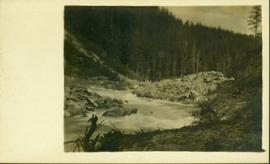
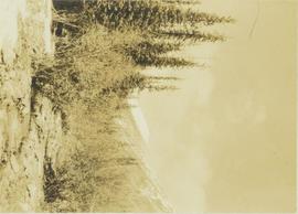
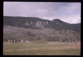
Image depicts layers of silt along the Chilako River near Blackwater Road, Prince George, B.C.
Image depicts a beehive burner covered in snow in Sinclair Mills, B.C. Map coordinates 54°01'17.4"N 121°40'53.0"W
Image depicts railway tracks and buildings with a beehive burner on the left. The location is likely Sinclair Mills, B.C. Map coordinates 54°01'17.4"N 121°40'53.0"W
Map reproduction of the Sinclair Spruce Lumber Co. Ltd. T.S.H.L. A01848 C.P. 310 cutting area, likely in the Aleza Lake Research Forest.
Image depicts the Skeena River at Hazelton, B.C.
Image depicts the Skeena River.
Image depicts the Skeena River at Hazelton, B.C.
Image depicts the Skeena River, as well as a stretch of highway that appears to be under construction.
Image depicts the Skeena River somewhere near Prince Rupert, B.C.
Reproduced map on mylar depicts locations of elevations and benchmarks at the Aleza Lake forest.
Image depicts the community of Skidegate on Haida Gwaii.
Image depicts a skier in a costume with a fake sword, somewhere on the Birchleg Ski route on Tabor Mountain in Prince George, B.C.
Image depicts a vehicle and a large group of skiers somewhere on Tabor Mountain in Prince George, B.C.
Image depicts numerous skiers and skis that are standing upright in in the snow on Tabor Mountain in Prince George, B.C.
Image depicts numerous skiers on the Birchleg Ski route on Tabor Mountain in Prince George, B.C.
Image depicts numerous skiers cross-country skiing on a trail through trees on the Birchleg Ski route on Tabor Mountain in Prince George, B.C.
Image depicts the sky at either dusk or dawn, from an unknown location.
Image depicts the slopes of Tabor Mountain in Prince George, B.C.
Image depicts a slough area while on approach to Bowron Lake.
Image depicts a few unknown individuals canoeing in a slough area while on approach to Bowron Lake.
Image depicts a slug on the forest floor somewhere on Haida Gwaii.
Photograph depicts sluice trunk in mining area, men on tall structure in background.
Image depicts what is likely a slump slide at an unknown location.
Image depicts an unknown individual standing near what is most likely a slump slide at an uncertain location.
Image depicts two unknown individuals standing near what is most likely a slump slide at an uncertain location.
Image depicts an unknown individual standing next to what appears to be a slump type of landslide at an unknown location.
Image depicts an aerial view of a section of land, likely near the Fraser River, that is possibly either a slump or part of a mining operation. The slide is labelled "slump or mining."
Image depicts the location of a slump type of landslide at Moose Heights, north of Quesnel, B.C.
Photograph of a small creek traveling through several rocky embankments.
Photograph depicts a small creek running through a wooded landscape with part of the Rocky Mountains visible in the background.
Image depicts an aerial view of what appears to be a small farm, possibly in the McGregor Canyon.
Image depicts a small lake somewhere in Mt. Robson Provincial Park.
Photograph depicts a small lake surrounded by a mountainous forest terrain. In the foreground a barren tree line is visible.
Image depicts a small mountain at an unknown location. The slide is labelled "basalt" for an unknown reason.
Image depicts a river at an uncertain location in either the Lillooet or Kamloops area.
Image depicts a view of what appears to be a small town at an uncertain location.
Item is a photograph of Mr. Williston, Chief Forester John Stokes and Tom Wright of Canadian Forest Products examining an area near Prince George in order to determine the timber area required for a Pulp Harvesting License for a proposed pulp mill that would depend completely on waste wood.