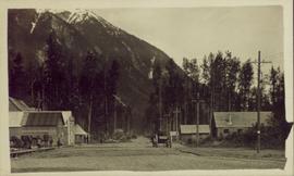
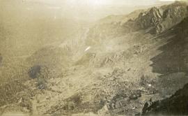
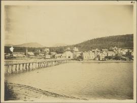
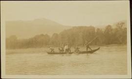
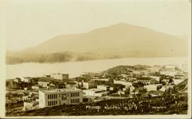
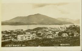
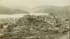
Showing 3593 results

Archival description
2011.13.24 · Item · ca.1910-ca.1930
Part of Parker photograph collection

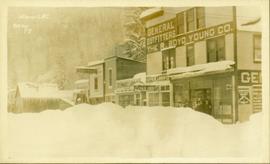
Street view of various buildings in Stewart, BC, covered with a heavy layer of snow. Visible businesses include "The R. Boyd Young Co." and "Stewart Land Co." Printed annotation on recto reads: "Stewart B.C. Hughes 78."

Dozer on Cliff
2000.1.1.3.15.10 · Item · [ca. 1958]
Part of Cassiar Asbestos Corporation Ltd. fonds

Photograph depicts unknown man driving bulldozer on edge of mine area at high elevation. The dozer is an International model TD24 (manufactured between 1947 and 1955). A second man stands on edge of cliff, directing driver. Expansive mountain range in background.

2000.1.1.3.15.17 · Item · 1961
Part of Cassiar Asbestos Corporation Ltd. fonds

Photograph depicts unknown man driving bulldozer on edge of mine area at high elevation. Mine road can be seen below leading to Cassiar plant in background on left, townsite visible on right. South mountain range in distance. Handwritten annotation on verso of photograph: "1961".

Driftwood Creek
2012.13.1.62.03 · Item · June 1978
Part of J. Kent Sedgwick fonds

Image depicts a number of identical buildings and vehicles at "Driftwood Creek" in the Driftwood Canyon Provincial Park.

Driftwood Station
2012.13.1.62.02 · Item · June 1978
Part of J. Kent Sedgwick fonds

Image depicts the Driftwood BCR station, possibly located near Driftwood Creek in the Driftwood Canyon Provincial Park east of Smithers, B.C.

Driveway in Newlands, BC
2012.13.1.87.102 · Item · [between 1975 and 1995]
Part of J. Kent Sedgwick fonds

Image depicts a driveway cordoned off by a red mesh material in Newlands, B.C. The address of the house is labelled 31951, and the name listed is "Fauchers." Map coordinates 54°06'47.8"N 122°08'22.4"W

2009.7.1.053 · Item · [ca. 1915?]
Part of Archdeacon W. H. Collison fonds

Photograph depicts buildings visible through clearing in trees. Water crosses foreground, hills visible in background.

Handwritten annotation on verso reads: "Dry dock / Prince Rupert B.C."

2000.1.1.3.18.003 · Item · September 1954
Part of Cassiar Asbestos Corporation Ltd. fonds

Photograph depicts large dry rock storage building in foreground on left, mill in background, dryer building in right midground. Miscellaneous supplies in far right foreground, mountains visible in background. Handwritten annotation on verso of photograph: "Sept 1954". This photograph was originally stored inside duotang labeled "CASSIAR ASBESTOS CORPORATION LIMITED PHOTOGRAPHS 1954"; photo caption beneath this image: "40,000 Ton Dry Storage Building / Mill / Dryer Building".

2000.1.1.3.18.004 · Item · September 1954
Part of Cassiar Asbestos Corporation Ltd. fonds

Photograph depicts large dry rock storage building in foreground on right, mill on left behind tailings pile, and dryer building in centre behind conveyor belt connecting mill to dry rock storage. A cloud can be seen rising from plantsite. Trees and Troutline Creek cross foreground, mine valley and mountains visible in background. Stamped annotation on recto of photograph: "ANSCO PRINTON Munshaw Colour Service Ltd. MAR 10 1955".

Drying sugar
2014.10.1.104 · Item · 1910
Part of Arthur Holland Land Surveying Collection

Photograph depicts a tarp spread out on the grass, two men sit nearby the tarp. There is a canvas tent in the background with a man standing beside it. Behind the tent is a low hill with a fence bordering the top of the hill. There are blankets drying on the fence.

Ducks
2012.13.1.50.055 · Item · 1978
Part of J. Kent Sedgwick fonds

Image depicts a large flock of ducks in a field full of water at an unknown location.

Dump Truck at Tailings Pile
2000.1.1.3.18.001 · Item · 1953
Part of Cassiar Asbestos Corporation Ltd. fonds

Photograph depicts red truck dumping waste at what is believed to be the tailings pile at the Cassiar plant. Small building and unidentified individual in bottom left foreground, valley and mountains in background. Photo caption next to printed copy of image in 1953 Annual Report: "Stockpile of 80,000 tons of Ore at Mill."

Dunlevy Creek?
2012.13.1.50.138 · Item · 2006
Part of J. Kent Sedgwick fonds

Image depicts the Dunlevy Creek area somewhere near Dawson Creek, B.C. The slide is simply labelled "Dunlevy irrigation" for uncertain reasons.

Dunlevy Creek?
2012.13.1.50.137 · Item · 2006
Part of J. Kent Sedgwick fonds

Image depicts the Dunlevy Creek area somewhere near Dawson Creek, B.C. The slide is simply labelled "Dunlevy irrigation" for uncertain reasons.

Eaglet Lake?
2012.13.1.87.082 · Item · [between 1975 and 1995]
Part of J. Kent Sedgwick fonds

Image depicts a lake at an uncertain location, likely Eaglet Lake.

Eaglet Lake Creek
2012.13.1.89.095 · Item · [1980?]
Part of J. Kent Sedgwick fonds

Image depicts the creek flowing into Eaglet Lake. A grey area of hill on the right side of the image appears to be the Giscome Quarry. Map coordinates 54°04'26.2"N 122°22'04.3"W

2000.1.1.3.24.02 · Item · Septmeber 1954
Part of Cassiar Asbestos Corporation Ltd. fonds

Photograph depicts wood houses behind stand of trees in Cassiar valley. Truck, power poles, and road in foreground, mountains in background. Typed caption below photo in original duotang album: "Two Bedroom Pan-Abode Houses - Cassiar Townsite". Handwritten annotation on verso: "Sept 1954".

2000.1.1.3.24.05 · Item · [ca. 1955]
Part of Cassiar Asbestos Corporation Ltd. fonds

Photograph depicts unidentified individual and cars on street in foreground, snow banks, trees, and power poles on either side. Buildings can be seen on far right, mountains visible in background. Handwritten annotation on recto of photograph: "townsite Looking East".

2009.7.1.067 · Item · [ca. 1873 - ca. 1920]
Part of Archdeacon W. H. Collison fonds

Photograph depicts town buildings on opposite shore. Beach and dock can be seen in foreground.

Handwritten annotation on verso reads: "Chapter XXII, No 1. Eastern Section of Port Simpson as christianized."

2011.3.3.65 · Item · 11 June 1915
Part of North Coast & Central BC Postcard Collection

Elevated photograph of Prince Rupert taken from a hill. Printed annotation on recto reads: "Prince Rupert BC McRae Bros." Handwritten annotation on verso reads: "11/June c/o PG Prince Rupert, B.C. Dear Rae[??], How about a letter. Love for all, Frank." Postcard is addressed to: "Miss R Boew. Bernie PG [illegible]." Postmark on verso reads: "Prince Rupert BC Jun 11 1 PM 1915."

Elks Flag Day, McBride, BC
2011.3.1.15 · Item · 5 January 1945
Part of North Coast & Central BC Postcard Collection

Photograph of several vehicles parked along a road. A large crowd is visible gathering in the background. Printed annotation on recto reads: "Elks Flag Day, McBride, B.C." Handwritten annotation on verso reads: "Jan. 5th 1945. Dear Dad, Am working in a lumber camp, advised by Prof. Johnson and Prof Casey. Altitude about 2,300. Think I will like it, if they don't make me work to[sic] heavy. the Climate and the grub is swell. Otherwise not so hot. Bye for now. Love Will." Postcard is addressed: "To: Mr. A.W. Hockin Big Valley, Alberta. From. W. Hockin c/o E.U. Lamming McBride, B.C."