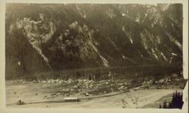
Street scene in Prince George B.C. Several Union Jack flags are visible and there is a celebration banner at the end of the street. Long shadows in photo indicate summer (perhaps Dominion Day?). River in foreground, railroad and city in mid ground and hill in background. Printed annotation on recto reads: “Prince George. B.C.”
Image depicts a street in Giscome B.C. The Giscome Store is located on the left side of the image with the church in the background. Map coordinates 54°04'18.5"N 122°21'57.7"W
Image depicts a street in Giscome. The store was previously located on the left. The church is in the background. Map coordinates 54°04'18.5"N 122°21'57.7"W
View of the road descending to the waterfront. Buildings and forested area are visible on either side of street. Annotation on recto reads: "Prince Rupert BC. '07."
Image depicts a view of the Dunkley Lumber Mill in Strathnaver, B.C.
Image depicts the BCR, as well as the Dunkley Lumber Mill, in Strathnaver, B.C.
Image depicts what is likely the Dunkley Lumber Mill in Strathnaver, B.C.
Image depicts an aerial view of Strathnaver, B.C.
Photograph depicts stores in Kaslo on Kootenay Lake, 40 miles northeast of Nelson. This town still has 15 miles of dirt road leading to it.
Photograph depicts a store 50 yards south of the B.C. Electric Railway on the west side of the Vedder crossing road in Sardis, Chilliwack, B.C.
Photograph depicts the only store in the small, derelict village of about 12-15 houses of which only one is occupied.
Image depicts a few storage sheds somewhere in Prince George, B.C.
Image depicts the school site in Stoney Creek.
Image depicts a stone marker in Lamming Mills, B.C.
Photograph depicts a stone house on 17th St. and Esquimalt St. in West Vancouver, B.C.
Elevated, wide angle photograph of Stewart, BC with mountains visible in the background.
Slightly elevated photograph of commercial and residential buildings in Stewart, BC. Printed annotation on recto reads: "Hughes #11 Stewart Looking N.W."
Image depicts the Robert Stewart house, built in 1910 and inhabited by the Stewart family until 1945. It is located in Stewart, B.C.
Image depicts Stewart Harbour in Stewart, B.C.
Photograph depicts view a panoramic view of Stewart B.C taken from the valley bottom.
Photograph depicts view a panoramic view of Stewart B.C. taken from an elevated view.
Image depicts an unknown individual leaning against a sign at the Stewart Access Road which warns travellers to pack several days of food. Located in Hazelton, B.C.
Image depicts a man, possibly Kent Sedgwick, leaning against a sign forbidding public traffic on the Stewart Access Road from between 5 am to 8 pm. Located in Hazelton, B.C.
Image depicts Stewart, with a section of Mt. Shorty Stevenson dominating the background.
Image depicts several houses in Stewart, B.C. A section of Mt. Shorty Stevenson is visible in the background.
Photograph depicts Stave Falls School, a type of rural school that was falling into disuse. This one was still in use and cared for.
Statue measures 2.7 metres tall. Town buildings in background.
Image is one of six photographs found with negatives in envelope reading: “‘Campaigning 1979,’ 6 colour negatives enclosed and 2- 4x5 prints (pictured with Bunne Hoffman - editor of Chetwynd Echo (now deceased)), Village of Chetwynd 1949 ?” See also items 2009.6.1.349 - 2009.6.1.354.
Photograph depicts a figure with two heads standing above stone reading "Here lies the last but not the least because He is the last of all his line the [?] Tribe ABEL WARD SOLOMON WARD". Bushes, building, and hill visible in background.
Handwritten annotation on verso reads: "Port Simpson BC".
Image depicts the start of Joffre Creek Road, most likely somewhere in the Joffre Lakes Provincial Park.
Image depicts a long line of people cross country skiing along the Birchleg route on Tabor Mountain in Prince George, B.C.
Image depicts a large vessel docked in Prince Rupert, B.C. The name on its side is "Star Capella." The slide itself is labelled "superport."
Image depicts the historic Lightening Inn in Stanley, B.C.
Photograph taken at Government House, Victoria, B.C.
Image depicts a stained glass window showing Saint Nicholas from the interior of a church in Shelley, B.C.
Image depicts a stained glass window showing Saint Joseph from the interior of a church in Shelley, B.C.
Image depicts a stained glass window showing Saint John from the interior of a church in Shelley, B.C.
Image depicts a stained glass window showing Saint Agnes from the interior of a church in Shelley, B.C.
Image depicts a stained glass window from the interior of an Anglican Church in Woodpecker, B.C.
Photograph depicts a 120 ft. stack of the former B.C. Copper Company in Anaconda, on the outskirts of Greenwood. It was built sometime between 1903 and 1909 and replaced a steel stack built on 1900, immediately below it.
Image depicts St. Peter's Church in Mackenzie, B.C.
Photograph depicts St. Paul's Anglican Church in Powell River. The church was built in 1955.
Image depicts the interior of the St. Marks Community Church in Stewart, B.C.
Image depicts the St. Marks Community Church in Stewart, B.C.
Image depicts the St. Mark's Anglican Church and a small house in Woodpecker, B.C.
Image depicts the St. Mark's Anglican Church and a small house in Woodpecker, B.C. There is an unknown individual present.
Image depicts the St. Mark's Anglican Church and a small house in Woodpecker, B.C.
Image depicts St. Mark's Anglican Church in Woodpecker, B.C.