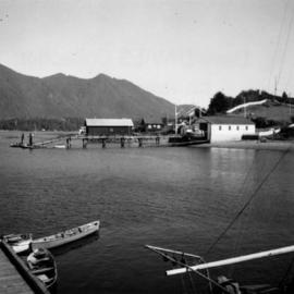
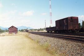
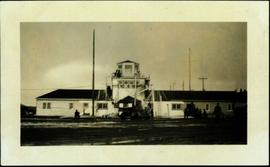
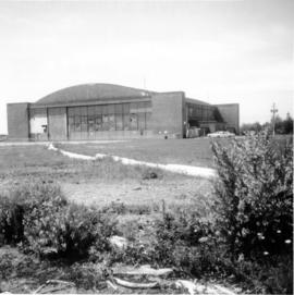
Photograph depicts the Tofino Airport. It was a former wartime RCAF base built in 1942 for anti-Japanese air patrols. It was now a D.O.T controlled airport.
Photograph depicts Tofino on Vancouver Island. View taken from wharf with a lifeboat on slip.
Violet Baxter's younger brother Tom Taylor stands in dress suit in gateway of picket fence. Unidentified building and porch in background.
Image depicts a tombstone, with the name and inscription written in what appears to be Chinese. It is most likely located somewhere in or near Kamloops, B.C.
Image depicts the tombstone of T.J. Menefee in the cemetery in Soda Creek, B.C.
Photograph depicts a tool house on a CNR curve in Armstrong. Not in frequent use.
Photograph depicts a disused tool house in Wasa, at the CPR Windermere Subdivision. Davies notes the structure was rarely seen at the time the photograph was taken.
Photograph depicts a tool house in Wasa, at the CPR Windermere Subdivision. Before 1970, the station had siding for 37 cars. Now it had two sidings for a total of 150 cars. Note the old box car with old lettering that was presumably on non-reserve service.
Groups of men and women can be seen gathered on paths between two large totem poles.
Handwritten annotation on verso reads: "Totem Park Pr Rupert park."
Photograph depicts a totem pole standing on what appears to be a large wooden deck or boardwalk, view of the city in background.
Handwritten annotation on verso reads: "Totem pole in park in Prince Rupert".
Image depicts several individuals examining totem poles which are possibly undergoing a restoration process somewhere on Haida Gwaii.
Totem poles (crest poles?) stand in front of a line of houses. Sandy beach in foreground, forest on hill in background.
Handwritten annotation on verso reads: "Kai sun W. Coast Q.C.I."
Totem poles (crest poles?) stand in front of wood building, hills visible in background.
Handwritten annotation on verso reads: "Poles on QC Isl."
Totem poles (crest poles?) stand in front of remains of wood structures, forest visible in background.
Handwritten annotation on verso reads: "A deserted Village, Q.C. Islands [...]" (various notes crossed through on verso).
Totem poles (crest poles?) stand in front of remains of wood structures built along sandy shore. View from above, forest on hill in background.
Handwritten annotation on verso reads: "[? illegible] Deserted village West Coast QCIs."
Unidentified people stand around and between totem poles. A row of buildings and snowy mountain peaks are visible in the background. Location is believed to be Kingcome Indian Village
Totem poles (crest poles?) stand in front of a line of houses. Blanketed canoes sit on beach in right foreground; forest in background.
Handwritten annotations on verso read: “skidegate village Queen Charlotte Islands as it appeared forty years ago"; "Rev W.E. Collison Prince Rupert"; "Hughes"; "1".
Totem poles (crest poles?) stand in front of forest trees, fallen logs on beach in foreground.
Handwritten annotation on verso reads: "Indian Totems along beach on Q.C. Islands"
Totem poles (crest poles?) stand in front of wooden houses on right. Hills on shoreline visible in background.
Handwritten annotations on verso read: "West Coast QCIs."; "[Old?] Kassan Alaska."
Handwritten photo album caption below this photo reads: "Tower & Adm. Bldg, Ft. Nelson." Photograph depicts long white building with tower raised in middle, ladders and scaffolding in front. Trucks and groups of men in foreground, some on building itself. Power poles in foreground and background.
Royal Canadian Air ForcePhotograph depicts a tower controlling the C.P.R. grade crossing at Alexander St. in Vancouver, B.C.
The photograph depicts a CN train engine next to a tower at the CN rail yard in Prince George, BC. Reproduction of photograph from 1984.
Photograph depicts the Cassiar valley: town in foreground, plant and tailings pile behind. Mine road can be seen from plant to mine valley on left. Mountain range in background.
Photograph depicts the Cassiar valley: town in foreground, plant and tailings pile in background.
Photograph depicts the Cassiar valley: town in left foreground, plant and tailings pile in midground, mountains in background. Photograph was taken from the air, portion of plane visible in top left of image.
Photograph depicts the Cassiar valley: town on left, plant and tailings pile on right, mountains in background. Mine road can be seen from plant to mine valley in top left of image.
Photograph depicts the Cassiar valley: town in foreground, plant and tailings pile in background. Mountain range visible in distance. Photograph was taken from above, facing east.
Photograph depicts the Cassiar valley: plant and tailings pile on left, town on right. Mountain range visible in distance. Photograph was taken from above, facing south.
Photograph depicts the town of Cassiar behind plant buildings in left foreground. Mountain base in background. Photograph was taken from the air, portion of plane visible in top left of image.
Photograph depicts the town of Cassiar, mountain base in background. Mine road visible in top right of image.
Photograph depicts the Cassiar valley: town on left, plant on right, mine valley in background. Photograph was taken from above, facing north east.
Photograph depicts the town of Cassiar behind plant and tailings pile in foreground. Mountain range in background.
Photograph depicts the town of Cassiar, mountain base in background.
Photograph depicts the town of Cassiar in foreground, mountain base in background. Photograph was taken from the air, portion of plane visible in top left of image.
Photograph depicts the Cassiar townsite in foreground. Mill, dry rock storage building, and tailings pile can be seen in background. Handwritten annotation on verso of photograph: "1958 [1961 crossed through]."
Photograph depicts the Cassiar plantsite including the mill, dry rock storage building, tailings pile, and many other buildings. A portion of the townsite can be seen on left.
Photograph depicts the Cassiar plantsite in foreground, including the mill, dry rock storage building, tailings pile, and many other buildings. Townsite in midground, mountains in background. Handwritten annotation on recto of photograph: "Cassiar."
Photograph depicts the Cassiar valley. Handwritten annotation on verso of photograph: "1958 [1961 crossed through]", on recto: "Cassiar Asbestos Corporation Limited. Cassiar B.C. Townsite in foreground mill and ore storage in left middle ground," "Toronto set". It is believed that this photograph was made into a post card.
Photograph depicts a track shed about 1 mile south of Beaverdell or at about mile 43.25 on the CPR line in the Carmi Subdivision. Despite the open doors and ease of access, it was the only hut on the line found to contain track materials and correspondence. It retained 50 memos addressed to the Section Foreman [at Beaverdell?].
Photograph depicts the track transfer transporter at the Canadian National Railway (CN) repair shops at Port Mann.
Photograph depicts the track transfer transporter at the Canadian National Railway (CN) repair shops at Port Mann, showing the east face of the main building.
Photograph depicts man standing in front of log building with the sign "RCMP" above center window. Moose antlers mounted on roof. Forest visible in background on right.
Image depicts a patch of snow-covered ground with a sign that reads "Trail of 98," somewhere along the White Pass railway.
Image depicts Upper Fraser residential area during demolition of town site. Map coordinates 54°06'51.6"N 121°56'26.3"W
Image depicts a number of trailer homes in Tumbler Ridge, B.C.
Image depicts trailer homes in Prince George, B.C.