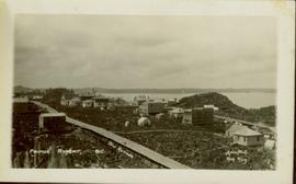
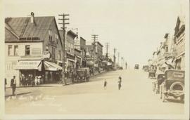
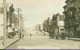
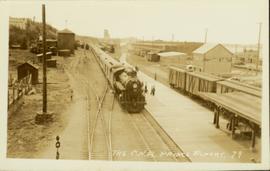
Slightly elevated front-facing photograph of a steam engine and cargo coming into a station in Prince Rupert, BC. Coal and lumber yards are visible in the background. Annotation on recto reads: "The C.N.R. Prince Rupert. 79."
Image depicts the Duchess engine, which was built in 1878 and taken out of service in 1919. It was part of a matched set with the Duke and is now a tourist attraction in Carcross, Y.T.
The item is a photograph depicting buildings for businesses named The Flip Side and Black Forest Food and Deli on 3rd Avenue in Prince George.
Photograph depicts a snow covered building. Annotation on verso of photograph states: "The good old winter time at the Hospital aR"
The item is a photograph depicting a stained-glass window from the church at Indian Reserve No. 2 in Shelley. The window is titled "The Good Shepherd" and depicts a saint holding a shepherd's staff and a lamb.
Photograph depicts numerous buildings with a grassy field in the foreground and a mountain range in the background. Annotation on recto of photograph states: "The Hospital at Hazelton"
Photograph of a large explosion next to a huge pile of debris. Buildings are visible on either side and railroad track can be seen in the foreground. Printed annotation on recto reads: "The Last Big Blast, Prince Rupert BC 21 Jan 1914 McRae Bros. Photo"
Photograph depicts the old post office and federal government building at 1299 3rd Avenue prior to the coat of arms removal. Annotation on verso: "fed. govt bldg, (post office), c. 1990, before, coat of arms, removal".
Side perspective street view of the Royal Hotel in Prince Rupert BC. The "Ladies [sic] Entrance" sign is visible on the right side of the building. Several vehicles can be seen on the street. Printed annotation on recto reads: " 3rd Ave Prince Rupert Photo W.W.W."
Photograph depicts the Soda Creek cemetery.
Bob White, a teacher, standing on the porch of the teacherage after a blizzard.
Side perspective of the teacherage located on Brown Ave. in Giscome. Photo taken in September. Handwritten annotation in pen on verso reads: “The Teacherage.”
Side perspective of the teacherage located on Brown Ave. in Giscome. Photo taken in November after the first snow. Handwritten annotation in pen on verso reads: “Our House.”
Photograph depicts the building for the Vancouver Supply Company located at 25 Alexander St. in Vancouver, B.C. It is at the center of the old downtown and may have been a former fire hall.
Photograph of a small vessel on the ocean with a dock and harbour buildings in the foreground. Tents and piles of lumber can be seen among the buildings. Annotation on recto reads: "The Wharf, Prince Rupert, BC. 1657."
Wide angle photograph showing 3rd and 2nd Avenue in Prince Rupert. Many buildings, both commercial and residential, and some tents are situated along the wooden roads. Annotation on recto reads: "Prince Rupert, BC. 3rd Avenue 2nd Avenue Allen Photo Aug 6/09."
Street level photo of Third Avenue in Prince George. Visible businesses include "Cut Rate Grocery" and "C.N.R. Cafe." Printed annotation on recto reads: "3rd Ave. Prince George."
Image depicts 3rd Ave in Prince George, B.C. Map coordinates 53°55'01.9"N 122°44'48.7"W
Wide angle photograph showing the intersection of 3rd Avenue and 6th Street, as well as 5th Street in Prince Rupert. Many buildings are visible along the wooden street including a building in mid-construction. Annotation on recto reads: "Prince Rupert, BC. 6th Street 3rd Ave. 5th St Allen Photo Aug 6/09."
Street view taken from the intersection of Third Avenue and Sixth Street in Prince George BC. A drugstore and several cafes can be seen on the left side of the street. Printed annotation on recto reads: "3rd Ave & 6th Street Prince Rupert BC."
Street view of several business in Prince Rupert BC. "McRae Bros. Ltd." and "Mussallems Economy Store" are situated on the right side of the street. Printed annotation on recto reads: " 3rd Ave Prince Rupert B.C. W.W.W."
Street view of Third Avenue in Prince Rupert. Printed annotation on recto reads: "Third Ave Prince Rupert B.C. Photo W.W.W."
Elevated view of Third Avenue in Prince Rupert. What appears to be a firetruck is travelling down the road. Printed annotation on recto reads: "3rd Ave W Prince Rupert BC."
Street view of Third Avenue in Prince Rupert, BC. Several cars are visible parked along the sides of the paved street. Printed annotation on recto reads: "Third Ave. W Prince Rupert- BC."
Photograph taken from the intersection of 3rd Avenue and an unidentified street. Visible businesses include "Ben Baird The Smart Shop" and "C.N.R. Cafe." Printed annotation on recto reads: "3rd Ave. PR. George, B.C."
Street scene depicting people, boardwalks, horse & wagons, and delivery truck. Printed annotation on recto reads: “3rd Ave. Prince Rupert. B.C.”
Hand coloured street view of Third Avenue in Prince Rupert, BC. Printed annotation on recto reads: "Third Avenue, Prince Rupert, B.C." Artist's mark in lower left corner reads: "109938 J.V."
Typed annotation in red ink on recto reads: “3rd Ave. Prince Rupert. B.C.” People, boardwalks, horse & wagons and store signs are visible. Rubble and unknown material lies on ground between boardwalks. Typed annotation in red ink on recto reads: “3rd Ave. Prince Rupert. B.C.”
The item is a photograph depicting the exterior of a house that was formerly Thompson Elementary School. The address is 4818 Giscome Road, Prince George, BC. Annotation on reverse side of the photograph states, "Thompson."
Forest in background.
Image depicts three unidentified children standing in the doorway of a house, with two goats ascending the porch steps. The location is uncertain, likely Sinclair Mills, B.C.
Item is a photograph of the three tunnels built to divert the Peace River around the Bennett Dam construction site.
Photograph depicts a man speculated to be H.F. Glassey standing between two other men behind large dog. The men stand smoking cigarettes in snowy area, unidentified buildings in background. Handwritten annotation on recto of photograph: "Bert Glassey Esq."
Ground level view of the Prince Rupert dry dock. Hills are visible in the background. Printed annotation on recto reads: "Three Million Dollar Dry Dock and Shipbuilding Plant, Prince Rupert, BC."
Each child is dressed in white and seated on deck in front of wood building. In descending order: Ellen, Violet, and Lucy. A barn, fence and forest can be seen in background. It is believed that the children are sitting in front of their home in Kispiox, B.C. See also items 2009.5.1.45 & 2009.2.1.46.
Image depicts two individuals seated at a picnic table while a third stands closer to the water on a beach somewhere in Kitimat, B.C. What appears to be a harbour can be seen on the water.
Image depicts three picnic tables, one of which is occupied with three unknown individuals, on a beach somewhere in Kitimat, B.C.
The item is a photograph depicting three white houses in a rural setting. The houses are separated by groups of trees.
The item is a photograph depicting three white houses in a rural setting. The houses are separated by groups of trees. Sign in front says, "Ministry of Agriculutre & Food."
The item is a photograph depicting three white houses in a rural area. The houses are separated by groups of trees.
The item is a black and white photograph depicting three white houses in a rural environment. The houses are separated by groups of trees.
Miscellaneous items are scattered in yard behind totem, house partially visible in background.
Handwritten annotation on verso reads: "Insert this illustration in Chapt. II. No. 2. 'Tlingit Totem.'"
Photograph depicts the Tofino Airport. It was a former wartime RCAF base built in 1942 for anti-Japanese air patrols. It was now a D.O.T controlled airport.
Photograph depicts Tofino on Vancouver Island. View taken from wharf with a lifeboat on slip.
Violet Baxter's younger brother Tom Taylor stands in dress suit in gateway of picket fence. Unidentified building and porch in background.
Image depicts a tombstone, with the name and inscription written in what appears to be Chinese. It is most likely located somewhere in or near Kamloops, B.C.
Image depicts the tombstone of T.J. Menefee in the cemetery in Soda Creek, B.C.
Photograph depicts a tool house on a CNR curve in Armstrong. Not in frequent use.
Photograph depicts a disused tool house in Wasa, at the CPR Windermere Subdivision. Davies notes the structure was rarely seen at the time the photograph was taken.