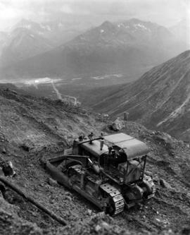
Photograph depicts unknown man driving bulldozer near edge of mine area at high elevation. Dozer is an International model TD24 (manufactured between 1947 and 1955). Valley and mountain range in background.
Photograph depicts unknown man driving bulldozer on edge of mine area at high elevation. Mine road can be seen below leading to Cassiar plant in background on left, townsite visible on right. South mountain range in distance. Handwritten annotation on verso of photograph: "1961".
Photograph depicts unknown man driving bulldozer on edge of mine area at high elevation. The dozer is an International model TD24 (manufactured between 1947 and 1955). A second man stands on edge of cliff, directing driver. Mountain range in background.
Photograph depicts unknown man driving bulldozer on edge of mine area at high elevation. The dozer is an International model TD24 (manufactured between 1947 and 1955). A second man stands on edge of cliff, directing driver. Expansive mountain range in background.
Photograph depicts unknown man driving bulldozer in foreground. Shop area in background, numerous haul trucks and dozers throughout. Old mine garage can be seen in center behind dozer, and the mine's West Peak rises on right behind shop buildings. Mountain range in background. Handwritten annotations on recto of photograph: "Cassiar Asbestos Corporation Limited. Cassiar B.C. Mining asbestos ore elevation approx 6000 ft. above sea level. McDame mountain, Northern British Columbia"; "Toronto Set"; "D - 336"; "-4 1/2 -". What appears to be framing measurements are annotated on verso.
Street view side perspective photograph of several businesses in downtown Stewart, BC.
Street view of various buildings in Stewart, BC, covered with a heavy layer of snow. Visible businesses include "The R. Boyd Young Co." and "Stewart Land Co." Printed annotation on recto reads: "Stewart B.C. Hughes 78."
Street view of downtown Stewart, BC. Photograph shows boards propped up over the swampy area of the future road. Wood debris litters the foreground.
Photograph of several buildings down the street in Prince Rupert, including the church. Lumber pallets are littered around the buildings. Annotation on recto reads: "Prince Rupert, BC. 20.10.07."
Image depicts Downton Lake, the Lajoie Dam reservoir.
Photograph depicts a view of well kept buildings, orchard and mountains in the background.
Photograph depicts a large farmhouse situated in an orchard.
Photograph depicts farms and orchards, with sparsely forested hills in the background.
Photograph depicts a view of well kept buildings, orchard and mountains in the background.
Photograph depicts orchards with mountains in the background.
Photograph depicts a view of well kept buildings, orchard and mountains in the background.
Photograph depicts orchards with mountains in the background.
Image depicts a small farm located in Dome Creek, B.C.
Image depicts the school and teacherage located in Dome Creek, B.C.
Image depicts a strangely shaped orange vehicle somewhere in Dome Creek, B.C.
Image depicts an old, unused log cabin somewhere in Dome Creek, B.C.
Image depicts a log cabin somewhere in Dome Creek, B.C.
Image depicts a small shack that became the later post office in Dome Creek, B.C.
Image depicts several houses in Dome Creek, B.C.
Image depicts a horse and a barn in Dome Creek, B.C.
Image depicts a farmhouse in Dome Creek, B.C.
Image depicts an old building that used to be a store and post office in Dome Creek, B.C.
Image depicts the community hall in Dome Creek, B.C.
Image depicts what is possibly the CN Station in Dome Creek, B.C.
Image depicts the CN Station in Dome Creek, B.C.
Image depicts a Catholic Church in Dome Creek, B.C.
Image depicts a house somewhere in Dome Creek, B.C.
Photograph depicts a team of dogs pulling a sled and an unidentified person across a very flat area under heavy clouds. Mountains in background. Handwritten annotations on verso of photograph: "Unbroken Trails", "Taylor". Photograph speculated to have been taken near Atlin, B.C.
Photograph depicts a team of dogs and sled resting in a very flat snow-covered area. Hills in background. Handwritten annotation on recto of photograph: "ATLIN."
Image depicts a pair of dogs in a forest, possibly somewhere near Woodpecker, B.C.
3 dog teams pulling 3 sleds with 6 men attending. There is a large mountain in the background. Printed annotation on recto reads: “Mail team Skeena River B.C.” Handwritten message on verso is address to “Dear Alice and dated March 23, Easter Sunday 1913”.
A woman stands in distance on a road with high snowbanks and trees on either side. A dog can be seen in foreground, facing woman. A fence and other structures stand in midground. Tree-covered slope in background.
Image depicts an unknown individual and a dog on a bridge over what is possibly the Robson River.
Image depicts a dog standing on a path through the woods somewhere in Carp Lake Provincial Park.
Image depicts a dog in a forest, possibly somewhere near Woodpecker, B.C.
Image depicts a house and numerous rundown vehicles in Dog Creek, B.C.
Photograph depicts dog seated on grass in foreground. Unidentified individuals visible below with fishing nets in waterfall area at Moricetown Canyon.
Image depicts a ferry docked at Haida Gwaii, B.C.
Image depicts numerous docked boats in Prince Rupert, B.C.
Image depicts numerous docked boats somewhere in Prince Rupert, B.C.
Image depicts numerous boats docked in Prince Rupert, B.C.
Image depicts an individual sitting on a dock on a lake somewhere on Haida Gwaii.