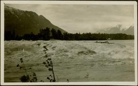
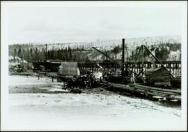
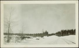
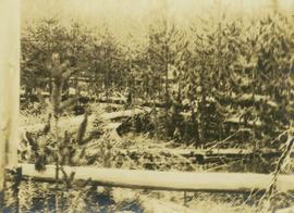
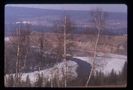
Photograph depicts winter landscape with track and logs in foreground. Bridge, trees and cleared land in background.
Photograph of a stretch of railroad passing by a small body of water. Mountains are visible in the background.
Image depicts two merging railway tracks, and what appears to be a frozen river, somewhere near the summit of a mountain.
Photograph depicts the Grand Trunk Pacific Railway Bridge crossing the Bulkley River. A smaller bridge speculated to be used by pedestrians stands below and parallel to the railway bridge. Photo was taken from shore, with opposite shore crossing midground. Trees in foreground, mountains in background. A small building can be seen at opposite end of bridge. Other sections of railway can be seen on hill in background. Handwritten annotation on verso of photograph: "HAZELTON BULKLEY BRIDGE."
Image depicts a group of individuals who appear to be searching through the rocks near a railway track. It is possibly part of an educational trip.
Photograph depicts snow bank between construction camp and railway tracks. Power lines and forest trees in background.
Footage of a rainbow that can be see through mist over a body of water, either a lake or river.
Possible locations include the Bella Coola River or the Dean River.
Image depicts a pair of Rainbow trout from Indianpoint Lake.
Image depicts the ranch house of the Ranch of the Vikings, originally owned and operated by Bjorger Pettersen, a member of the Canadian Ski Hall of Fame, from 1970 until 1985. It is located somewhere west of McBride, B.C.
Photograph depicts a man and horse standing outside a log cabin covered in snow and icicles. In the foreground of the image several loaded packs are laid out surrounding the cabin. The cabin belonged to ranger Alex Nelles' and was located at Willow Creek.
Slide depicts the Ranger Station at the Aleza Lake Experiment Station.
Slide depicts a burning building at the Aleza Lake Experiment Station on the date it was shut down by the BC Forest Service.
Handwritten annotation on verso reads: "Canyon on Nass River". Forest and mountains visible on shore in distance.
Image depicts a view of Raven Lake in the background.
Image depicts Raven Lake.
Image depicts a view of Raven Lake.
Image depicts a view of Raven Lake and the surrounding area.
Image depicts a view of the area surrounding Raven Lake.
Image depicts several individuals hiking in the area surrounding Raven Lake.
Image depicts several individuals hiking in the area surrounding Raven Lake; the lake is visible in the background.
Image depicts a view of the area surrounding Raven Lake.
Image depicts several individuals hiking in the area surrounding Raven Lake.
Image depicts a small section of the area surrounding Raven Lake.
Image depicts a woman standing on the porch of a hut located by Raven Lake.
Image depicts Raven Peak in the Sugarbowl Grizzly Den Protected Area located on Highway 16 east of Prince George, B.C.
Image depicts a view of the area surrounding Raven Peak.
Image depicts several individuals walking the Raven trail.
Image depicts an individual sliding down a snowy trail somewhere Raven Peak.
Image depicts the Rearguard Falls in Rearguard Falls Provincial Park near Tête Jaune Cache along the Yellowhead Highway.
Image depicts what appears to be a receding glacier on the slopes of Mt. Robson.
Image depicts a road, forest, and hill rise in an uncertain location possibly near Red Rock, B.C.
Item is a presentation of research about the transfer of Aboriginal knowledge to early female scientists for Ainley's Social Science and Research Humanities Council (SSHRC) project, "Re-explorations: Gender, Science and Environment in the 19th and 20th Century Canada and Australia."
Photograph depicts regenerating pine trees in a burn area.
Handwritten annotation on recto of photograph: "RETAINING RIBS JUNE 29/64". Photograph depicts construction workers on and near wooden framework structure extending from base of crusher building. Crane in background against mountainside. Miscellaneous construction equipment and materials throughout.
Image depicts a river and a hillside at an unknown location.
Image depicts a river, possibly the Nechako, in Prince George, B.C. Possibly taken from the Foothills Bridge.
Image depicts a river at an uncertain location.
Image depicts a river, possibly the Fraser, at an uncertain location.
Image depicts a river at an uncertain location.
Image depicts what is possibly a section of the Tseax River.
Image depicts a man in a canoe on a river somewhere in South Tweedsmuir Provincial Park. The man is possibly Kent Sedgwick.
Image depicts a canoe on a river somewhere in South Tweedsmuir Provincial Park.
Image depicts a river, possibly either the Nechako or the Fraser, and a mountain range from an unknown location.
Image depicts a river on the left of the image and a range of mountains in the distance, located somewhere near Bralorne, B.C.
Image depicts what appears to be a small, narrow river, and mounds of snow. The location is uncertain.