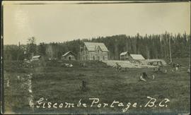
Photograph depicts people and tree stumps in grass areas. Buildings stand on higher level in midground, forest in background. Handwritten annotation on verso of photograph: "Giscombe Portage. B.C.", on recto: "Seaback & Huble"
Image depicts a parking lot full of vehicles with the Giscome store in the background. Map coordinates 54°04'18.5"N 122°21'57.7"W
Image depicts the Giscome mill foreman's house on the hill, with Eaglet Lake in the background and numerous piles of logs in the foreground. Map coordinates 54°04'28.0"N 122°22'05.8"W
Image depicts the Giscome mill foreman's house on the hill. Map coordinates 54°04'28.0"N 122°22'05.8"W
Image depicts an open area with Eaglet Lake in the background. It depicts the previous site of the mill at Giscome, B.C. Map coordinates 54°04'19.7"N 122°22'04.7"W
Image depicts the Giscome railway station and buildings remaining in townsite in Giscome, B.C. Map coordinates 54°04'18.0"N 122°22'04.7"W
Image depicts several houses and the Giscome saw mill in Giscome, B.C. in the background. Map coordinates 54°04'20.9"N 122°21'53.1"W
Image depicts a row of houses at an uncertain location, possibly in Giscome, B.C.
Image depicts Giscome with the school on the left, the remnants of the town site in the middle and the church on the right. Map coordinates 54°03'58.2"N 122°22'04.8"W
Image depicts a farm in Giscome, B.C.
Image depicts a dock at an inlet of Eaglet Lake in Giscome, B.C. There are numerous logs and other pieces of wood scattered in the foreground. Map coordinates 54°04'34.9"N 122°21'50.0"W
Image depicts a large, old and collapsing barn, as well as a nearby house of the dairy farm in Giscome, B.C. Map coordinates 54°03'53.3"N 122°21'22.6"W
Image depicts the dairy farm in Giscome, B.C. Map coordinates 54°03'53.3"N 122°21'22.6"W
Image depicts the Giscome Community Hall in Giscome, B.C. Map coordinates 54°04'18.5"N 122°21'57.7"W
Image depicts what is possibly the CN Railway Station and tracks located in Giscome, B.C.
Image depicts the old CN station in Giscome, B.C. Map coordinates 54°04'20.7"N 122°22'01.1"W
Image depicts the new CN station in Giscome, B.C. Map coordinates 54°04'20.7"N 122°22'01.1"W
Image depicts the old CN station in Giscome, B.C. Map coordinates 54°04'20.7"N 122°22'01.1"W
Image depicts the Giscome bunkhouse in Giscome, B.C. Map coordinates 54°04'17.6"N 122°22'06.1"W
Image depicts the Giscome mill site in Giscome, B.C. The bunkhouse is the large building with many windows. A train and railroad tracks are in the foreground. Map coordinates 54°04'17.6"N 122°22'06.1"W
Image depicts a street of houses in Giscome, B.C. Map coordinates 54°04'20.9"N 122°21'53.1"W
Image depicts the remains of a street of houses in Giscome, B.C. The quarry is slightly visible in the background. Map coordinates 54°04'20.9"N 122°21'53.1"W
Image depicts mill site and dock in Giscome, B.C. with Eaglet Lake in the background covered in ice. There is a large crowd of people gathered near the dock. Map coordinates 54°04'34.9"N 122°21'50.0"W
Image depicts the CN Station, with bundles of wood sitting near the tracks, in Giscome, B.C. Map coordinates 54°04'32.3"N 122°21'42.3"W
Image depicts a church in Giscome, B.C. Map coordinates 54°04'16.2"N 122°21'54.3"W
Image depicts a Catholic church in Giscome, B.C. Map coordinates 54°04'15.5"N 122°21'52.1"W
Image depicts the Giscome, B.C. town site with the Giscome railway station and the Giscome store in the center surrounded by vehicles. Map coordinates 54°04'18.5"N 122°21'57.7"W
Photograph depicts a girls' school, Strathcona Lodge, at Shawnigan Lake.
Photograph depicts an existing girder bridge, in use since 1962. A new concrete bridge was being built on the left.
Photograph depicts an old girder bridge.
The item is a photograph depicting the exterior of Ben Ginter's house. The windows are boarded up. The location is on an unnamed road in Prince George.
The item is a photograph depicting the view of Prince George from the front of Ben Ginter's house. The location is on an unnamed road in Prince George.
The item is a photograph depicting Ben Ginter's house. The house is white and the windows and garage doors are boarded up. The location is on an unnamed road in Prince George.
The item is a photograph depicting the exterior of Ben Ginter's house. The windows are boarded up. The location is on an unnamed road in Prince George.
The item is a photograph depicting the front Ben Ginter's house. The house is white and stone, the windows boarded up. The location is on an unnamed road in Prince George.
The item is a photograph depicting the exterior of Ben Ginter's house. The windows and garage doors are boarded up. The location is on an unnamed road in Prince George.
Image depicts the Ginter Property in Prince George, B.C.
Image depicts a private driveway, most likely leading to the Ginter Property in Prince George, B.C.
Image depicts a swimming pool filled with debris in the interior of the Ginter House in Prince George, B.C.
Image depicts the interior of the Ginter House in Prince George, B.C.
Image depicts what appears to be a part of a fence on the Ginter Property in Prince George, B.C.
Image depicts the Ginter House in Prince George, B.C.