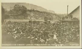
Print preview Close

Showing 3487 results

Archival description
3098 results with digital objects Show results with digital objects
Old House in Penny, B.C.
2012.13.1.87.119 · Item · [between 1970 and 1990]
Part of J. Kent Sedgwick fonds

Image depicts an old house in Penny and a woman, possibly Sue Sedgwick, standing in front of it. The location is uncertain.

Old House in Sinclair Mills
2012.13.1.87.019 · Item · [between 1975 and 1995]
Part of J. Kent Sedgwick fonds

Image depicts an old house missing windows and doors in the foreground, and a bunkhouse in the background, in Sinclair Mills, B.C. Map coordinates 54°01'17.4"N 121°40'53.0"W

Old Mill?
2012.13.1.50.157 · Item · [1982?]
Part of J. Kent Sedgwick fonds

Image depicts what appears to be an old mill at an unknown location.

Old Slump
2012.13.1.50.064 · Item · 1978
Part of J. Kent Sedgwick fonds

Image depicts an old slump type of landslide. The slide labels it as being near "McAlister."

Old Trestle
2012.13.1.100.22 · Item · 1999
Part of J. Kent Sedgwick fonds

Image depicts an old trestle along the White Pass railway, and the White pass Train on the left of the image.

2006.25.1.61 · Item · Apr. 1962
Part of Al Elsey Moving Images Collection

Footage of a "stink box" used in Ooligan grease production in what is assumed to be Bella Coola. Also there is footage of some men fly-fishing on a river shore, either the Bella Coola River or the Dean River. There is a close-up clip of them baiting a hook, and then a shot of the men using gaff and hook to haul fish to shore. The men display their catch for the camera and there is a panoramic view of the mountains behind them. Included are some clips of Robson's deer, and a white robin.

Possible other locations in this film include the Atnarko region, Rainbow Mountains, Ulgoatcho Mountains and Chilcotin area.

Open Field in Giscome
2012.13.1.87.069 · Item · [between 1975 and 1995]
Part of J. Kent Sedgwick fonds

Image depicts a field in Giscome, B.C. On the right side of the image, in the background, is a grey strip that appears to be a mine, possibly the quarry at Eaglet Lake in Giscome, B.C. Map coordinates 54°03'52.9"N 122°22'10.0"W

Open Field in Giscome
2012.13.1.87.068 · Item · [between 1975 and 1995]
Part of J. Kent Sedgwick fonds

Image depicts a field in Giscome, B.C. On the right side of the image, in the background, is a grey strip that appears to be a mine, possibly the quarry at Eaglet Lake in Giscome, B.C. Map coordinates 54°03'52.9"N 122°22'10.0"W

Open Field in Giscome
2012.13.1.87.163 · Item · [between 1975 and 1995]
Part of J. Kent Sedgwick fonds

Image depicts an open field and Giscome, B.C. in the background. Map coordinates 54°03'52.9"N 122°22'10.0"W

Open Pit
2012.13.1.50.093 · Item · [1978?]
Part of J. Kent Sedgwick fonds

Image depicts an open mining pit at an uncertain location; it is possibly Gibraltar.

Orchard Irrigation
2012.13.1.82.27 · Item · 1981
Part of J. Kent Sedgwick fonds

Image depicts water flowing through an irrigation channel in an orchard, somewhere in or near Seton Portage, B.C.

Oscar Peak
2012.13.1.57.24 · Item · 1982
Part of J. Kent Sedgwick fonds

Image depicts the north aspect of Oscar Peak overlooking Lava Lake in the Nass Valley.

Oscar Peak
2012.13.1.57.25 · Item · 1982
Part of J. Kent Sedgwick fonds

Image depicts the north aspect of Oscar Peak overlooking Lava Lake in the Nass Valley.

Otter Creek, BC
2009.5.2.70 · Item · 6 June 1937
Part of Taylor-Baxter Family Photograph Collection

Photograph depicts a shallow creek winding through dirt area, forest in background. Handwritten annotation on verso of photograph: "Otter Creek Showing overlying moraine 6/6/37". See also item 2009.5.2.69.

2000.1.1.3.14.02 · Item · 1952
Part of Cassiar Asbestos Corporation Ltd. fonds

Photograph depicts a pick hammer hanging from outcrop. Annotations on note glued to recto of photograph: "ASBESTOS"; "Outcrop of fibre bearing serpentine about centre of deposit and vertically over 300 adit on western slope." Areas of image have been labeled "A" and "B". Photo caption under printed copy of image in 1952 Annual Report: "A - indicates asbestos talus. B - indicates asbestos veinlets."

2009.7.1.277 · Item · [ca. 1880-1920]
Part of Archdeacon W. H. Collison fonds

Wide angle photograph of many buildings scattered in a clear cut area. Foreground shows several businesses, including "Kelly Carruther's Supply" and "Prince Rupert Hardware and Supply Co." Some remaining forest is visible in the background. Annotation on recto reads: "Prince Rupert, BC 1659."

2011.12.05 · Item · [ca. September 1950- June 1951]
Part of Giscome, BC Historical Photograph collection

Photograph of various plant life with Eagle Lake visible in the background. Handwritten annotation in pen on verso reads: “Eagle Lake from the top of the bluff. Eagle Lake is about 7 miles long & about 1 mile wide. It is a fair sized lake.”