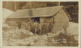
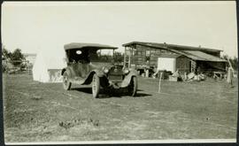
Photograph of a group of male trappers posing in front of a log cabin. Printed annotation on recto reads: "Moonlight Cabin Enroute to Naas #90."
Tall monument featuring a man's profile stands in foreground. Base of monument features writing on plaques.
Handwritten annotation on verso reads: "No. 30 Paul [Segaics?] Monument at Port Simpson".
The item is a photograph depicting the exterior of old damaged buildings on the Moffat farmland. There is a fence at the entrance to the driveway with an address sign that reads "1820."
The item is a photograph depicting the exterior of old damaged buildings on the Moffat farmland. There is a fence at the entrance to the driveway with an address sign that reads "1820." Annotation on the back of the photograph states, "Moffatt (Gunn) farm 2005."
The item is a photograph depicting the exterior of old damaged buildings on the Moffat farmland. There is a fence at the entrance to the driveway with an address sign that reads "1820."
Photograph depicts car parked in dirt yard. House stands in background on right, surrounded by miscellaneous items. White tent stands in left background. Water and shore visible in distance. House believed to belong to the Bourchier's niece Jean (see items 2009.5.3.120 & 2009.5.3.122).
The item is a photograph depicting a 1/48 scale model of the Cameron Street bridge. The angle is looking down the bridge with a blue and a yellow model car on the bridge. Annotation on the reverse side of the photograph states, "Oct. 2008 1/48 scale model of the Cameron St. bridge 1931-2005 by Roy Groeneveld."
The item is a photograph depicting a 1/48 scale model of the Cameron Street bridge. The angle is a side view of the bridge with a blue and a yellow model car on the bridge. Annotation on the reverse side of the photograph states, "Oct. 2008 1/48 scale model of the Cameron St. bridge 1931-2005 by Roy Groeneveld."
Photograph depicts large square model of the new mill building that was built at the Cassiar plant site in 1970. Model is displayed on green material set on a platform in snowy area. Machinery modeled inside the structure is colour-coded. Mountain in background.
Photograph depicts large square model of the new mill building that was built at the Cassiar plant site in 1970. Model is displayed outdoors on a platform that stands on four saw horses. Machinery modeled inside the structure is colour-coded. Plant buildings and mountains in background.
Photograph depicts large square model of the new mill building that was built at the Cassiar plant site in 1970. Model is displayed on green material set on a platform in snowy area. Machinery modeled inside the structure is colour-coded. Mountain in background.
Photograph depicts large square model of the new mill building that was built at the Cassiar plant site in 1970. Model is displayed on green material laid on floor against wall in unidentified room. Machinery modeled inside the structure is colour-coded.
Image depicts a dog and dog house in the back of a pick-up somewhere near Prince George, B.C.
Photographs depict large building in fenced area, trees in yard and in background.
Handwritten annotations on verso read: "Mission House at Massett QCIs"; "Mission House at Massett - Mother & Dad lived there."
Photograph depicts tall building, with long shorter section crossing midground in front. Path runs through garden in foreground.
Handwritten annotation on verso reads: "Back of Mission House Kincolith".
Photograph depicts a large two-storey building with the sign: "CALEDONIA HOSPITAL". Fence crosses foreground, hills visible in background.
Handwritten annotation on verso reads: "Mission Hosp at Metlakatla B.C."
Photograph depicts the Mission City rail and road bridge. It is owned by the CPR and was opened in 1891. It was used by road vehicles between 1 July 1927 and the 23 June 1973, using a one way flow system. On the latter day, a new high level road bridge was unofficially opened. By early July 1973, the CPR had removed the wooden deck planking.
Photograph depicts the Mission City CPR depot located at mile 87.3 from North Bend in Cascade Substation. It was built in 1902 and add onto in 1909. It has living quarters on the 2nd floor that are still in use, which is quite rare for BC in 1973.
Photograph depicts the Mission City CPR depot located at mile 87.3 from North Bend in Cascade Substation. It was built in 1902 and add onto in 1909. It has living quarters on the 2nd floor that are still in use, which is quite rare for BC in 1973. It is 41.7 miles from Vancouver and 2, 839.6 miles from Montreal.
Handwritten annotation on verso reads: “Cuba with Chuck Pilfold, ‘77”.
Photograph believed to have been taken during a Ministry of Sport Tour in Cuba, 1977 - 1978. See also items 2009.6.1.198 - 2009.6.1.224.
The item is a photograph depicting the front of a white house. The sign on the front reads, "Ministry of Agriculture & Food Reception."
The item is a black and white photograph depicting the front of a white house. The sign on the front reads, "Ministry of Agriculture & Food Reception."
Handwritten annotations on verso read: “East Berlin GDR, Spt. Minister,” and “16394/2”. Photograph taken during European Sports Tour with Team Canada.
Photograph is a printed postcard depicting an unidentified mining building situated on a hillside surrounded by mining debris. Possibly located in Stewart B.C.
Photograph depicts lumber piles and what appears to be a very long sluicing trough along Otter Creek. Forest and hills in background. Handwritten annotation on verso of photograph: "Otter Creek 6/6/37". See also item 2009.5.2.70.
Photograph depicts the Cassiar mine above valley, north mountain range in background. Tramline station and crushing plant visible to west of pit. Photograph was taken from the air, portion of plane visible in top left of image.
Photograph depicts the Cassiar mine in foreground, north east mountain range in background. Tramline station and crushing plant visible in foreground in front of pit. Photograph was taken from the air, portion of plane visible in top left of image.
Photograph depicts the Cassiar mine in foreground, north east mountain range in background. Tramline station and crushing plant visible in foreground, west of pit. Photograph was taken from the air, portion of plane visible in top left of image.
Photograph depicts the mine road in valley, view from mountain above. Plant, tailings pile, and town visible in distance. South mountains in background. Handwritten annotation on recto of photograph: "1961-1962".
Photograph depicts view of mine road in valley, from mountain above. Plant, tailings pile, and town visible in distance. South mountains in background. Handwritten annotation on verso of photograph: "1961", on recto: Townsite and Plantsite from mine."
Photograph depicts the mine road in valley bellow mine. Cassiar plant and tailings pile in foreground. Handwritten annotation on recto of photograph: "Oct. 25 / 65 4:25 PM."
Photograph depicts the primary crushing plant in foreground. Mine road can be seen below, and plant is visible in distance. South mountains in background. Handwritten annotation on recto of photograph: "1961-1962".
Switchback road, power lines and tramline towers are believed to be visible in the background valley. Construction of a long structure near the edge of the excavation area can be seen in midground; this is speculated to be the section of the crusher building which housed conveyor "B".
Photograph depicts a mine 200 yards south of Moyie village, which is 20 miles south of Cranbrook. It produced silver, zinc, and lead from 1900-1910 and had a smelter a quarter mile away. The shaft was 900 ft. deep, with levels going under Moyie Lake. The head gear dates from 1925-1935 and has electric winding.
Photograph depicts the mine buildings of the mine at Coal Creek that closed in 1959. The newer buildings date to circa 1930. Much of the standard gauge trackage of Morrissey, Fernie, and Michel railway (subsidiary of the Great Northern Railway) in mine area remains. The track between Coal Creek and Fernie has not been lifted.
Photograph depicts a mine building at the copper mine in Britannia Beach. The mine was still in use and well maintained.
Photograph depicts the pit mine, and road in valley below. Town of Cassiar can be seen in distance at foot of south mountain range.
Photograph depicts the town of Cassiar in distance behind pit mine in foreground. South mountain range in background. Photograph was taken from the air, portion of plane visible in top left of image.
Photograph depicts the pit mine, and road in valley below. Town of Cassiar can be seen in distance at foot of south mountain range.
Photograph depicts the Cassiar mine. North and South peak featured in background, and West peak in left foreground. Pit is being developed between South peak and West peak. Old mine garage is visible in lower centre of image, and crushing plant in right foreground. Mountain range in distance.
Image depicts a view of the Millar Addition suburb in Prince George, B.C.
Overview of the Giscome sawmill behind road. Lumber yard is visible in foreground while mill stands in background.
Handwritten annotation in pencil on verso: "Giscome Mill / lumber yard in foreground".
Item is a photograph of a small mill operation.
Photograph depicts the Mill of Kintail near Almonte, Ontario prior to 1930.
Photograph depicts the Mill of Kintail in Ontario after renovations circa 1976 when it became the R. Tait McKenzie Memorial Museum and conservation site, located near Almonte, Ontario.
Man driving a two horse cart in front of beehive burner, cart is full of bark presumably sawed off the logs.
Handwritten annotation in pencil on verso: "Mill Burner".
Photograph depicts a mill and beehive burner.
Parade of uniformed marchers with sign that reads: “Every little helps, Do your share” (with a large cross). Buildings on street in background. Printed annotation on recto reads: “Prince Rupert B.C.” Handwritten annotation in pencil on verso reads: “Prince Rupert B.C.”