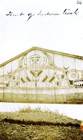
Photograph depicts a tomb elevated over grassy area.
Handwritten annotation on image reads: "26. Front of Indian tomb."; on verso: "Upper Nass River."
Photograph depicts a tomb elevated over grassy area.
Handwritten annotation on image reads: "26. Front of Indian tomb."; on verso: "Upper Nass River."
Handwritten annotation on recto of photograph: "Front St. Hazelton in Winter. 12 J.W. [...]" Tree line, field, and hills in background. Handwritten annotation on verso of photograph: "Miss. Nellie [Nelville] G. Caranaugh".
Street view photograph taken at the intersection of Front Street and Carson Avenue. Several men are gathered at Cowan's Hardware store on the corner. Also visible in this photograph is the Cariboo Hotel (visible furthest to the left), and the British American Hotel which is partially visible behind the J.A. Fraser store. Printed annotation on recto reads: "On Front Street, Quesnel, B.C."
The photograph depicts three metal fuel tanks at the exterior of the CN roundhouse in Prince George, BC. Reproduction of photograph from 1984.
Image depicts the entrance of the Fulton River.
Image depicts a number of people standing at what appears to be a farm fishery [?] on the Fulton River.
Elevated street view of Fulton Street in Prince Rupert, BC. City Hall is in the left foreground. Hills and water are visible in the background. Printed annotation on recto reads: "Fulton St. Prince Rupert. B.C. W.W.W."
Photograph depicts a group of men, women, and children walking across beach towards water. Buildings visible on shore in left background.
Handwritten annotation on verso reads: "Funeral party - en route to boat Metlakatla BC (Taking body over to Grave Island".
Photograph depicts two log buildings in fenced area on lake shore, forest trees in background. A man can be seen standing near docking area and small boat pier extending into water in foreground. Handwritten annotation on recto of photograph: "Fur Farm Red Rock Lake". This location is believed to at mile 27, north of Summit Lake.
Handwritten annotation on recto of photograph: "FURNACE PAD AUG 25/64." Photograph depicts construction worker standing on elevated wood platform. Three other men can be seen working in construction area. This location is believed to be under the conveyor to crusher building, retaining wall in midground.
Image depicts Gang Ranch in the Upper Fraser Canyon.
Image depicts the general store and post office on Gang Ranch.
Image depicts the house of the owner of Gang Ranch.
Image depicts the Gang Ranch House in the Upper Fraser Canyon.
Image depicts Gang Ranch, with a sign warning that the area is patrolled by Range and Logging Patrols, in the Upper Fraser Canyon.
Image depicts the Upper Fraser Canyon from what appears to be the entrance to Gang Ranch.
Image depicts a wooden structure at Gang Ranch. It is possibility an elevated water trough.
Image depicts the Gang Ranch house.
Image depicts the Gang Ranch office.
Image depicts the sign to Gang Ranch, located in the Upper Fraser Canyon, with graffiti on it.
The item is a black and white photograph depicting a garage and covered storage area on a farm.
Image depicts a gas compression station located at Summit Lake, north of Prince George, B.C.
Image depicts a gathering of people for an uncertain event at an uncertain location, possibly in Lillooet, B.C. A few tents are set up in the picture.
Image depicts a gauging tower at Shelley, B.C.
Handwritten photo album caption below this photo reads: " 'General Duties' (G.D.) man at Officers' Quarters." Photograph depicts man in sweater vest and tie sitting in front of closed door with "R.C.A.F OFFICERS QUARTERS" printed on side. There is a broom on right, boots on left, and wood slat sidewalk in foreground.
Royal Canadian Air ForcePhotograph depicts young girl standing on front deck of "WANAMAKER'S GENERAL MERCHANDISE." Car visible on left, gas pump in front. Trees and neighbouring house visible in background. Handwritten annotation on recto of photograph: "ATLIN."
Photograph depicts a general store owned by Acton Kilby that was still operated by him at age 81. His family had moved from New Westminster in 1902 to run the store. The CPR depot originally connected direcly to the second floor of the building. Harrison Mills lay at the junction of the Harrison and Fraser Rivers and was an important site during steamboat days. Now it was a backwater of 3 dwellings beside the railway.
Slightly elevated view of an intersection surrounded by residential and business buildings in Prince Rupert BC. Printed annotation on recto reads: "General View Prince Rupert. B.C. W.W.W."
Photograph depicts the general view of the waterfront buildings between Burrard and Thurlow St., in Vancouver Harbour looking northwest from Burrard St. The Immigration Building is on the left and the "Princess of Vancouver" (C.P.R.) is in the middle distance.
Photograph depicts a general view, looking north, of Westview Harbour with the Powell River paper plant smoking in the background.
The item is a photograph of the Generator Cabaret building on 3rd Avenue in Prince George.
Handwritten photo album caption below this photo reads: "S/L. Geo Du Temple. #4 Unit N.W.S.R. Watson Lake." Photograph depicts man in uniform (wings medallion on left breast) standing in front of white doorway of log building. Ground in foreground covered with sticks and sawdust.
Royal Canadian Air ForceHandwritten annotation on verso reads: “The KGB + We in Vienna - World Hockey Championships 1977 - Geoff Gowen - Roger Jackson to left”. Building is the Museum of King Jan III's Palace at Wilanów, Warsaw, Poland
Photo depicts a street perspective of George St., in Prince George, BC, ca. 1950. Annotation recto reads: "George St. Prince George BC Photo by J Wrathall." Handwritten annotation in pen on verso of postcard reads: “This is the Hastings Street of Prince George. This & 3rd Streets are the main thoroughfares.”
Image depicts a view of George Street with the Prince George City Hall at the corner of George Street and 7th Avenue.
Image depicts a view of George Street with the Prince George Hotel.
Printed annotation on recto reads: “George St. Prince George B.C.”, handwritten in pencil on verso reads: “CA. 1915”
Street level photo of George Street in Prince George, Visible businesses include the "Prince George Hotel" and "Ford" dealership. Printed annotation on recto reads: "George St. Looking North Prince George, B.C. N&D."
Handwritten annotation on verso of photograph reads: "George St. Prince George BC Photo. S Wrathall". Prince George Hotel and Cafe stand on left side of street in foreground, and many other buildings and businesses can be seen. Vehicles line the street, cut banks visible in background. Photograph believed to have been taken while George Street was being prepared for a new lawyer of asphalt.
Street level photo of George Street in Prince George. Visible businesses include "B-A" and "Astoria Hotel." Printed annotation on recto reads: "George St. Prince George."
Image depicts the Germansen River, with the buildings of Germansen Landing visible on the other side.
Image depicts a child in the foreground, and the Germansen Landing trading post in the background in Germansen Landing, B.C.
Image depicts a helicopter in Germansen Landing, B.C.
Image depicts the Germansen Landing Trading Post.
Photograph depicts "Gifts to Remember," a gift shop on 3rd Avenue, The Bay in the background.
Image depicts the Ginter House in Prince George, B.C.