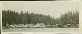
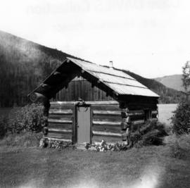
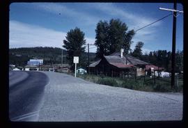
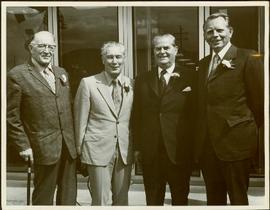
The photograph depicts a blurred image of a yellow carpet with colourful designs.
Photograph depicts the Nanaimo passenger depot of the Esquimalt and Nanaimo Railway (at right) and the E & N freight shed (at left).
Image depicts several eighteen wheelers at the Pass Lake Road and Upper Fraser Road intersection with numerous houses and buildings in the background in McGregor, B.C. Map coordinates 54°04'38.1"N 121°50'00.1"W
Photograph depicts a partially demolished Great Northern Railway depot and Canadian National Railway (CN) depot behind it, in Vancouver.
Overhead view of a block of business and harbour buildings in Prince Rupert BC. The "Savoy Hotel" is visible in the foreground. Printed annotation on recto reads: "Part of Business Section & Harbour. Prince Rupert B.C. F. Button Photo Pr. Rupert No. 494."
Image depicts Parkside Intermediate Care Home on Ospika Boulevard in Prince George. Map coordinates 53°55'02.6"N 122°47'41.6"W
Image depicts a group of people throwing a frisbee in a parking lot at an uncertain location, likely in the Peace River Region.
Photograph depicts a parking lot and alleyway behind the Europe Hotel on 3rd Avenue.
This item is a photograph of a yellow parkade in downtown Prince George. Liquidation World can be seen in the background.
This item is a photograph of a yellow parkade in downtown Prince George.
Photograph of several floats parading down Second Avenue in Prince Rupert. A large crowd is gathered. Annotation on recto reads: "Photo by MacRae Bros Prince Rupert BC Prince Rupert B."
Balcony overlooks Terrace Gardens in Victoria, B.C.
Photograph depicts a painting on the fence outside a courthouse on Howe and Granville St. In Vancouver, B.C. Each artist was granted a permit and panel by City Council.
Photograph depicts a painting on a fence outside a courthouse on Howe St. in Vancouver, B.C. The painting shows the natural grandeur of B.C. partially blocked out by a super motel with a bewildered moose forced to become an ornamental fountain. The whole forecourt is being bulldozed to make way for the Centennial fountain.
Photograph of many loaded pack horses in front of the "McMillan Transfer Company." Printed annotation on recto reads: "Pack-Train At Bitter-Creek Hughes 116."
Photograph depicts the Pacific Press Ltd. Vancouver Sun building at Beatty and West Pender St. The view is looking northeast from Beatty St. It was vacated by the Vancouver Sun at Christmas 1965 with the neon "Sun" sign on the tower removed.
Photograph of a large waterfront factory. Annotation on recto reads: "Pacific Mills, Ocean Falls, BC. No. 2935."
Photograph of Stewart BC taken from a distance. Trees in the foreground slightly obscure the village, and a large mountain is visible in the background. Printed annotation on recto reads: "Stewart B.C. Hughes 93."
Postcard overview of several identifiable storefronts built amongst the rocky outcrops of Prince Rupert. Printed annotation on recto reads: "Prince Rupert BC."
Overhead photograph of Prince George, BC ca. 1950 with hills in background. Annotation on recto reads: "Prince George, B.C."
Overhead photograph of Giscome buildings with Eaglet Creek running through the foreground. Handwritten annotation in pen on verso reads: “Notice the flatness of the land. Part of our community.”
Overhead photograph of Giscome with the Eagle Lake Sawmill's beehive burner clearly visible in left foreground. Handwritten annotation in pen on verso reads: “Part of our community. school * ”
Elevated street view of Fulton Street in Prince Rupert, BC. City Hall is in the left foreground. Hills and water are visible in the background. Printed annotation on recto reads: "Prince Rupert. B.C."
Photographic overview of the Eagle Lake Sawmill. Handwritten annotation in pen on verso reads: “The mill.”
Overhead photograph of a forested area, with Stewart, BC visible in the distance.
Overhead view of commercial buildings in downtown Prince George. Printed annotation on recto reads: "Prince George, B.C."
Overhead view of a residential area in Prince Rupert, BC. Printed annotation on recto reads: "Prince Rupert, BC Photo by J.W."
Wide angle photograph of many buildings scattered in a clear cut area. Foreground shows several businesses, including "Kelly Carruther's Supply" and "Prince Rupert Hardware and Supply Co." Some remaining forest is visible in the background. Annotation on recto reads: "Prince Rupert, BC 1659."
Overhead view of many commercial buildings in Prince Rupert, BC. Printed annotation reads: "Prince Rupert, BC."
Image depicts a group of individuals on the sidewalk outside Spee-Dee Printers on Brunswick Street in Prince George, B.C.
Photograph depicts an outhouse on Notch Hill in the Shuswap. Helper locomotives were stationed here to lift heavy trains over Notch Hill. It was presumably used by waiting engine crews.
Image depicts what is likely an outhouse at Island Cache.
Exterior side view of a Catholic church built between 1876-1878 by Father George Blanchet. Handwritten annotation on verso in pencil reads: “Our Lady of Good Hope, Stuart Lake, Fort St. James, BC ”
Photograph depicts a fishing camp with boats and buildings on floating docks and a forested environment visible in the background. Handwritten annotation on verso states: “1960 Seymour Inlet. Oscar Johnston’s Camp on the Move. Taken from Mission Ship Columbia”; photographer’s stamp on verso states: “W.E. Nicholson”
Photograph depicts an original trappers cabin on Staubert Lake.
Image depicts a number of buildings at an uncertain location; the slide labels the older building in the image as potentially being the "original road house."
Image depicts the original steam engine for the White Pass Train, located in Skagway, Alaska.
Image depicts the original bank building in Wells, B.C.
Item is a photograph of Mr. Williston and Premier W.A.C. Bennet with two other gentlemen at the official opening of the provincial Government Building in Williams Lake.
Photograph depicts an open grassy field surrounded by trees in Soda Creek.
Image depicts a field in Giscome, B.C. On the right side of the image, in the background, is a grey strip that appears to be a mine, possibly the quarry at Eaglet Lake in Giscome, B.C. Map coordinates 54°03'52.9"N 122°22'10.0"W
Image depicts an open field and Giscome, B.C. in the background. Map coordinates 54°03'52.9"N 122°22'10.0"W
Image depicts an open field and numerous buildings, including a church in Giscome, B.C. Map coordinates 54°04'03.2"N 122°22'04.6"W
Handwritten caption beside this photo reads: "1500wt 4x4". Photograph depicts small open cab truck with tire chains. Forest and unidentified buildings in background. A second vehicle is semi-visible on far left, as well as a pile of logs on far right.
Photograph depicts a group of men gathered around hole in ice. Two men in centre handle a net full of fish. Village can be seen on shore in background.
Handwritten annotation on verso reads: "Oolichan Fishing Nass River".
Photograph depicts groups of men gathered on ice. One man sits on ice sled in foreground. Village can be seen on shore in background.
Handwritten annotation on verso reads: "Chapt. II. No. 1. Fishing Bay. Olachan fishery on the ice."