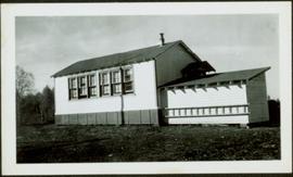
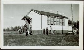
Item is a photograph of Pilot Mountain School.
Item is a photograph of Pilot Mountain School taken from the back
Photograph depicts Pier B of C.P.R., just west of the C.P.R. railway station. This is the only pier accessible to ocean going passenger liners and is used by P&O vessels. Facilities generally in adequate for the 1960s.
Perspective of Port Simpson and pier as seen from the water.
Perspective of pier and wharf as seen from the water. Port Simpson and hill in background. Sternwheeler can be seen on shore.
The item is a photograph of PG Pawn Shop and an unknown commercial building on 3rd Avenue Prince George.
Image depicts the Prince George Multiplex.
Image depicts an individual walking on a a log bridge in a forest somewhere on Haida Gwaii.
Photograph depicts an unknown person eating at a picnic table on a house construction site.
The item is a photograph of the Peoples Drug Mart, London Hotel and Da Moreno Italian restaurant on 3rd Avenue in Prince George. Scotiabank building is visible in the background.
Photograph depicts people sitting on chairs in a circle in a backyard.
Image depicts several unidentified individuals standing on a bridge; it possibly crosses the peace River.
Image depicts a group of people observing splintered wooden boards at an uncertain location.
Image depicts several unidentified individuals and a bridge behind them; it is possibly crossing the Peace River.
Photograph depicts the Penticton CPR depot. The view is looking northwest.
The photograph depicts Penny train station next to the train tracks. There is a girl sitting in front of the station. Annotation on slide states, "Penny Station 0118."
The photograph depicts a man and a woman standing outside Penny Station. The first-floor windows are boarded up and one of the upper windows has broken glass.
The photograph depicts Penny train station next to the train tracks. Annotation on reverse side of photograph states, "Penny formerly at Lindup." Annotation on 35 mm slide states, "Penny."
The photograph depicts Penny train station next to the train tracks. Annotation on slide states, "0117 Penny."
The photograph depicts Penny train station next to the train tracks. A girl is sitting in front of the station. Annotation on slide states, "0116 Penny."
Image depicts the community hall in Penny, B.C.
Image depicts the CN Station in Penny B.C. A woman, possibly Sue Sedgwick, is sitting against the outside wall.
Image depicts the CN Station in Penny B.C.
Image depicts a railway crossing sign with peeling and cracked paint somewhere in or near Penny, B.C.
Image depicts the post office in Penny, B.C.
Image depicts Sue Sedgwick standing in front of an old, run-down house somewhere in or near Penny, B.C.
Image depicts two signs for hiking trails in Penny, B.C. One reads: "Hiking trail to Red Mt. Lake (Grizzly Bear Mt.) expect to meet wild animals."
Image depicts a beehive burner somewhere in or near Penny, B.C.
Image depicts the condominiums in the "Pemberton Valley Estates" in Pemberton, B.C.
Image depicts rail road tracks and several buildings in Pemberton, B.C.
Image depicts a view of Peden Hill in Prince George, B.C.
Photograph depicts peat barns on the New Westminster Highway on Lulu Island, near the #8 Rd., half a mile west of rail crossing.
Image depicts the Pearson Homestead.
Photograph depicts buildings and signage on either side of dirt road. Unidentified man stands on far left, Atlin Lake and mountains can be seen in background.
Hand inscribed annotation on recto of photograph reads: “Pearl St., Atlin, B.C. Aug. 1899. A.C. Hirschfeld, No.74”.
Photograph depicts tent buildings on either side of dirt road. Unidentified men are visible on left, Atlin Lake and mountains can be seen in background.
Hand inscribed annotation on recto of photograph reads: “Pearl Av. looking towards Atlin Lake, Atlin, B.C., A.C. Hirschfeld, No. 174”
Image depicts a street of shops at an uncertain location somewhere in the Peace River Regional District. A pink and blue building, possibly a theatre, is labelled "Lux."
Image depicts the W.A.C. Bennett Dam on the Peace River in Hudson's Hope, B.C.
Image depicts a dam and a reservoir of water, possibly on the Peace River.
Image depicts a dam, possibly on the Peace River.
Image depicts a dam on what is possibly the Peace River.
Image depicts the Peace Canyon Dam and generating station under construction on the Peace River.
Side perspective photograph of a Portland Canal Short Line engine being either loaded or unloaded by several men at the station in Stewart, BC. Printed annotation on recto reads: "Aug 9 1911 Stewart BC."
Image depicts the remains of an old bridge, somewhere near Pavilion Mountain.
Image depicts the First Nations village of Pavilion, B.C.
Image depicts an old theatre owned by Paul Aivazoff in Prince Rupert, B.C. It opened in 1935 and was closed in 1981; it has since been renovated for retail use.
The photograph depicts a blurred image of a yellow carpet with colourful designs.