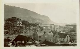
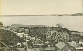
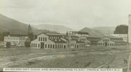
Print preview Close

Showing 4258 results

Archival description
3217 results with digital objects Show results with digital objects
2009.7.1.053 · Item · [ca. 1915?]
Part of Archdeacon W. H. Collison fonds

Photograph depicts buildings visible through clearing in trees. Water crosses foreground, hills visible in background.

Handwritten annotation on verso reads: "Dry dock / Prince Rupert B.C."

2000.1.1.3.18.003 · Item · September 1954
Part of Cassiar Asbestos Corporation Ltd. fonds

Photograph depicts large dry rock storage building in foreground on left, mill in background, dryer building in right midground. Miscellaneous supplies in far right foreground, mountains visible in background. Handwritten annotation on verso of photograph: "Sept 1954". This photograph was originally stored inside duotang labeled "CASSIAR ASBESTOS CORPORATION LIMITED PHOTOGRAPHS 1954"; photo caption beneath this image: "40,000 Ton Dry Storage Building / Mill / Dryer Building".

2000.1.1.3.18.004 · Item · September 1954
Part of Cassiar Asbestos Corporation Ltd. fonds

Photograph depicts large dry rock storage building in foreground on right, mill on left behind tailings pile, and dryer building in centre behind conveyor belt connecting mill to dry rock storage. A cloud can be seen rising from plantsite. Trees and Troutline Creek cross foreground, mine valley and mountains visible in background. Stamped annotation on recto of photograph: "ANSCO PRINTON Munshaw Colour Service Ltd. MAR 10 1955".

Dunlevy Barn
2012.13.1.50.146 · Item · 2006
Part of J. Kent Sedgwick fonds

Image depicts an old barn located somewhere near Dunlevy Creek in the Dawson Creek area.

Dunster
2012.13.1.6.234 · Item · July 1982
Part of J. Kent Sedgwick fonds

Image depicts an old, rundown building in Dunster, B.C. Possibly a disused Rail Station.

Dunster
2012.13.1.6.232 · Item · July 1982
Part of J. Kent Sedgwick fonds

Image depicts an old, rundown building in Dunster, B.C. Possibly a disused Rail Station.

Dunster
2012.13.1.6.233 · Item · July 1982
Part of J. Kent Sedgwick fonds

Image depicts an old, rundown building in Dunster, B.C. Possibly a disused Rail Station.

Dunster
2012.13.1.6.235 · Item · July 1982
Part of J. Kent Sedgwick fonds

Image depicts an old, rundown building in Dunster, B.C. Possibly a disused Rail Station.

Dunster train station
2012.13.2.15.22.1 · Item · [ca. 1980]
Part of J. Kent Sedgwick fonds

The photograph depicts Dunster train station next to twinned train tracks. Annotation on slide states, "Dunster."

2009.7.1.288 · Item · July 1911
Part of Archdeacon W. H. Collison fonds

Photograph of several commercial and residential buildings, including the church and "The Big Furniture Store." Annotation on recto reads: "Prince Rupert. BC Allen Photo July '11." Handwritten annotation on verso reads: "Early day- Prince Rupert."

2000.1.1.3.13.13 · Item · 1959
Part of Cassiar Asbestos Corporation Ltd. fonds

Photograph depicts the North peak of McDame mountain in the earlier stages of strip mining, South peak unmined in background. Quonset and other shops visible in left foreground, unknown building built into mountainside in right foreground.

2000.1.1.3.24.02 · Item · Septmeber 1954
Part of Cassiar Asbestos Corporation Ltd. fonds

Photograph depicts wood houses behind stand of trees in Cassiar valley. Truck, power poles, and road in foreground, mountains in background. Typed caption below photo in original duotang album: "Two Bedroom Pan-Abode Houses - Cassiar Townsite". Handwritten annotation on verso: "Sept 1954".

2009.7.1.304 · Item · [ca. 1880-1920]
Part of Archdeacon W. H. Collison fonds

Photo of the Prince Rupert harbour. Many buildings are visible along the shoreline. Annotation on recto reads: "Harbour, Prince Rupert BC. 1658." Handwritten annotation on verso reads: "Early Prince Rupert. Good view of Metlakatla Passage in distance- showery[?] Wolf Island."

2012.13.2.11.11.02 · Item · 11 Feb. 1998
Part of J. Kent Sedgwick fonds

The item is a photograph slide reproduction depicting houses in flood waters on the east end of Prince George. Annotation states, "1936 east end."

2009.7.1.067 · Item · [ca. 1873 - ca. 1920]
Part of Archdeacon W. H. Collison fonds

Photograph depicts town buildings on opposite shore. Beach and dock can be seen in foreground.

Handwritten annotation on verso reads: "Chapter XXII, No 1. Eastern Section of Port Simpson as christianized."

2013.6.36.1.028.11 · Item · 17 Sept. 1970
Part of David Davies Railway Collection

Photograph depicts the CPR line at Eholt, located at mile 108.7 from Nelson on the Boundary Subdivision. It was a formerly bustling junction with the left-hand spur leading to Phoenix. Nor it only has 3 way freight trains a week from Nelson to Midway. The view is looking west.