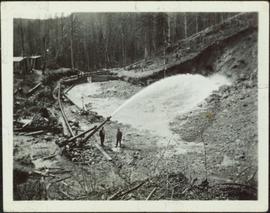
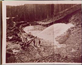
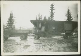
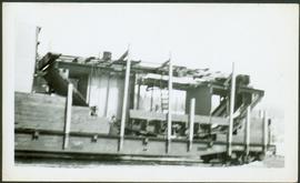
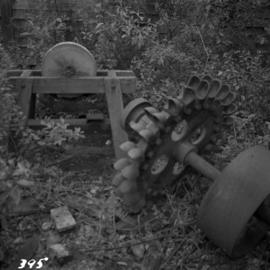
Photograph depicts an old pelton wheel at a former quarry at Granite Falls on the northeast head of the Indian Arm.
Photograph depicts small square building with an elevated door, log pile on its left, and stand of trees in background. Handwritten photo caption below photograph reads: "Old Salmon cache. Fort St James, BC June 1923".
Photograph depicts two men standing beside beds of fish laid out to dry. More oolichan fish hang on tall structures in background.
Handwritten annotation on verso reads: "'Food for winter' Oolichans drying at Fishing Bay, Nass River".
Photograph depicts a group of men gathered around hole in ice. Two men in centre handle a net full of fish. Village can be seen on shore in background.
Handwritten annotation on verso reads: "Oolichan Fishing Nass River".
Photograph depicts groups of men gathered on ice. One man sits on ice sled in foreground. Village can be seen on shore in background.
Handwritten annotation on verso reads: "Chapt. II. No. 1. Fishing Bay. Olachan fishery on the ice."
Footage of a "stink box" used in Ooligan grease production in what is assumed to be Bella Coola. Also there is footage of some men fly-fishing on a river shore, either the Bella Coola River or the Dean River. There is a close-up clip of them baiting a hook, and then a shot of the men using gaff and hook to haul fish to shore. The men display their catch for the camera and there is a panoramic view of the mountains behind them. Included are some clips of Robson's deer, and a white robin.
Possible other locations in this film include the Atnarko region, Rainbow Mountains, Ulgoatcho Mountains and Chilcotin area.
Handwritten caption beside this photo reads: "1500wt 4x4". Photograph depicts small open cab truck with tire chains. Forest and unidentified buildings in background. A second vehicle is semi-visible on far left, as well as a pile of logs on far right.
Image depicts an open mining pit at an uncertain location; it is possibly Gibraltar.
Item is a photograph of officials attending the June opening of the Crestwood Forest Industries pulp mill in Cranbrook, until that time the only pulp mill built without benefit of a Pulp Harvesting Area (PHA) license to assure timber supply. Mr. Williston is on the left.
Operator loading Asbestos into feeder at Welshpool Asbestos Mill in Australia.
Valley and mountain range visible in background. Handwritten annotation on recto of photograph: "Cassiar June 1970 / Looking South to 6200 Switch-back -".
Photograph depicts exposed asbestos fibre in talus below outcrop. Handwritten annotation on verso of photograph: "Sept 1954."
Photograph depicts a pick hammer hanging from outcrop. Annotations on note glued to recto of photograph: "ASBESTOS"; "Outcrop of fibre bearing serpentine about centre of deposit and vertically over 300 adit on western slope." Areas of image have been labeled "A" and "B". Photo caption under printed copy of image in 1952 Annual Report: "A - indicates asbestos talus. B - indicates asbestos veinlets."
Handwritten caption beside this photo reads: "Damage to Cassiar Grader, result of hazardous access to site". Rocks and rubble in foreground, mountain in background. Grader appears to be sitting on edge of cliff.
Photograph depicts large dump truck on its side in snowy forest clearing, exhaust still running. Lumber piles in foreground. Handwritten caption above this photo reads: "Over Easy".
Photographic overview of the Eagle Lake Sawmill. Handwritten annotation in pen on verso reads: “The mill.”
Overhead photograph of Giscome with the Eagle Lake Sawmill's beehive burner clearly visible in left foreground. Handwritten annotation in pen on verso reads: “Part of our community. school * ”
Photograph depicts an oxen powered log carrier with wheels that are approximately 10 feet in diameter. It is at Pioneer Park and Museum near Totem Lake, 3 miles north of Yahk and 30 miles east of Creston.
Sign says "Pacific Great Eastern Railway Company - Explosives - Handle Carefully - Keep Fire Away - North Vancouver Station June 25 1969". Also includes condensed rules for handling cars with explosives.
Photograph of a large waterfront factory. Annotation on recto reads: "Pacific Mills, Ocean Falls, BC. No. 2935."
Photograph depicts the lumber yard at Peden Hill sawmill, likely after the fire that burnt down the first mill at that location.
Image depicts an aerial view of areas that have been used for logging around Prince George, B.C.
Image depicts an aerial view of the Ahbau area somewhere near Prince George, B.C.
Map depicts the Shuswap Lakes, Rogers Pass, Kamloops, Yellowhead Pass, Thompson Valley, and the Nicola Valley. Also includes the first clues to a treasure hunt.
Photograph depicts a two men standing on piles of whale bones at a whaling station. Annotation on verso of photograph states: "Pile of whale bones, Whaling station, Vancouver Is."
Photograph depicts the Pinchi Lake mercury mine as seen from the water. Some buildings appear to be under construction. Handwritten annotation on verso reads: "Pinchi Lake min (mercury).
Photograph depicts a portion of the pit in foreground at the Cassiar mine. Crushing plant visible in centre below base of West peak. Footwall road in midground, mine valley in background. Building near trucks at top of pit was called the "shifter shack," where crews were relieved or dropped off for work.
Photograph depicts the pit head refuse at Extension Coal Mine, 5 miles southwest of Nanaimo. It worked between 1901 and 1931.
Photograph depicts view of pit mine, taken facing east. Town of Cassiar can be seen in distance at foot of south mountain range. Photograph was taken from the air, portion of plane visible in top left of image.
Photograph depicts a portion of the Cassiar pit in right foreground. Crushing plant visible to left of pit, West peak visible in right background. Mountain range can be seen in distance.
Photograph depicts an unidentified man mining in rocky area, trees and hills in background. Handwritten annotations on verso of photograph: "PLACER MINER WSHING FOR GOLD FINDLAY RIVER BC", "PHOTO WWW".
Two men stand below a large upright hose that is spraying a powerful stream of water against the side of a rocky hillside. Annotation on verso of photograph states: "Placer Mining Hixon (Hungry Thirties) This picture taken on top off Hill Across from Ques. Qarts. Maybe 800 Ft. west of Quarty There pictures taken approx 45 years ago Your friend(?) Box 156 Squamish B.C. Dec. 19/78"
Photo is adhered to paper backing, upon which handwritten annotation on recto reads: “Placer mining Hixon B.C. Hungry 30ies. This picture taken on top of hill across from Quesnel Quartz Mine maybe 800 ft west of Quartz taken approx 45 yrs ago (1933) 1978.12.19”
Five unidentified miners pose for a photo. Logs and wood scraps in foreground, forest in background.
Printed annotation on recto of photograph: "PLACER MINING, ATLINTOD RIVER, ATLIN, B.C. A.C. HIRSHFELD NO. 753."
Plan depicts the CNR rail yard in Kamloops. The plan was originally drafted on March 6, 1928 and updated to July 1937.
Plan depicts the Canadian Pacific Railway yards in Kamloops and the proposed connection between CPR and CNR. Includes a CPR track profile, profiles of street crossing, and enlargements.
Plan depicts the proposed CNR rail yard layout in Kelowna. A later plan, dated May 30th 1925, shows drastically reduced trackage and no barge slip.
Plan depicts a proposed location for a CNR station and crossing in Kelowna.
Plan depicts the proposed location and layout for the Canadian Northern Pacific terminal at Kamloops on the Kamloops-Lumby branch.
Map depicts the growth of Vancouver's street car system as from the laying of the first tracks in 1889 to the last section laid (Clark Dr., Hastings to Venables).
Photograph of plastic inserts from Nordenham Finishing Mill in Germany. Part of trip report.
Photograph of plastic inserts at Nordenham Finishing Mill in Germany. Part of trip report.
Image depicts a pulp mill in Port Edward, B.C.
Detailed floor plan for fish-processing plant in Port Simpson. The drawing includes production plan showing locations of the workers.
Photograph depicts boy on bike, and group of men in front of hull on trailer pulled by truck. Railway tracks visible on right, forest and hills in background.
Photograph depicts a crane behind rail tracks on left, main hook block suspended above boat hull resting on railway flatbed. Group of men in foreground, one man on hull. Trees and hills in background.
Photograph depicts boat hull resting on trailer flatbed pulled by truck. Trees and hills in background.
Photograph depicts middle section of boat hull on flatbed, trees in background.
Photograph depicts large square model of the new mill building that was built at the Cassiar plant site in 1970. Model is displayed on platform draped with green material. Machinery modeled inside the structure is colour-coded.
Photograph depicts extreme close up of colour-coded machinery modeled inside large square model of the new mill building that was built at the Cassiar plant site in 1970.