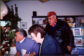
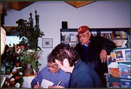
Photograph depicts Justa Monk and Bridget Moran seated at table, signing copies of 'Justa: a First Nations Leader'. Plants, bookshelves, and unidentified man visible in background.
Photograph depicts Justa Monk and Bridget Moran seated at table, signing copies of 'Justa: a First Nations Leader'. Plants, bookshelves, two unidentified individuals also visible in image.
Large-format map depicts the Monkman Public Sustained Yield Unit (PSYU) east of Prince George.
Large-format map depicts the Monkman Public Sustained Yield Unit (PSYU) and Tree Farm Licence 30 east of Prince George.
Videotape contains footage of: 19-Jan-04 - Moose footage by Roy Rea - UNBC and Smithers
Videotape contains footage of: 14-Oct-04 - Moose on campus - Bullwinkle / 30-Nov-04 - Moose research on vehicle collisions in urban areas - Rea, Roy / 1-Dec-04 - First medical lecture delivered from Northern Health Sciences Centre to UBC and UVic - Browne, Alister (UBC)
Photograph depicts Moran wearing regalia and holding an unidentified item in the Canfor lecture theater at the University of Northern British Columbia in Prince George, B.C. Group sits against wall in foreground and in theater seats in background. Flags and speakers can be seen against far wall. Cameras and photographers also visible in image.
Photograph depicts Moran wearing regalia and standing at podium while reading at the University of Northern British Columbia in Prince George, B.C. Group sits in foreground and background. Flags and speakers can be seen against far wall.
Photograph depicts Morris Donaldson at "Words, Loves" conference.
Handwritten caption below this photo reads: "Bought in Picture Prince George". Photograph depicts a mother grizzly bear standing on her hind legs against tree, so that her facial profile is visible. Two cubs stand on hind legs facing and leaning against her.
Image depicts Mr. P.G. and the Tourism Information site at the intersection of Highway 16 and 97. Map coordinates 53°53'46.5"N 122°46'00.7"W
Image depicts a snow sculpture of the Mr. P.G. lounging on a couch, possibly during the Winter City Conference, in Prince George, B.C. Taken at the Prince George Civic Center. Map coordinates 53°54'45.6"N 122°44'59.6"W
Item is a photograph of Mr. Williston washing dishes with Mrs. Evelyn Yost, Dormitory Matron, and Mrs. Houghtaling, Chief Cook, in the kitchen of the renovated army barracks which became the Prince George School’s first dormitory. The dormitory was the first of its kind in B.C.
Image depicts Mud River, also known as the Chilako River, at Blackwater Road, Prince George, B.C.
Videotape contains footage of: 22-Apr-05 - Multiplex (Part 1)
Videotape contains footage of: 22-Apr-05 - Multiplex (Part 2)
Left to right: Interior University Society President Murray Sadler, Prince George Mayor John Backhouse, Chancellor Iona Campagnolo, and President Geoffrey R. Weller.
Handwritten annotation on verso reads: “Construction of UNBC”.
Videotape contains footage of: 29-Oct-01 - naming of the Geoffrey R. Weller Library - Weller, Jean; Nord, Douglas
Image depicts natural meadows, possibly east of Prince Georg, B.C.
Image depicts a nature trail on Cottonwood Island.
Videotape contains footage of: 4-May-07 - NCMA; Cozzetto and Colin Kinsley on $2 million dollar Northern Medical Program Trust; Soccer
Photograph depicts two connected buildings; the building on the left is possibly the theatre, other building with sign that reads: "The Nechaco (sic?) General Stores." Boardwalk with people and unpaved street in foreground.
Photograph depicts bridge over Nechako River. Sloped cutbanks on opposite shore in background. Buildings and railroad tracks can be seen on town shore in right foreground.
Photograph depicts bridge over Nechako River. Sloped cutbanks on opposite shore in background. Railroad tracks can be seen on town shore in right foreground. Handwritten annotation on verso of photograph: "NECHAKO RIVER NEAR PRINCE GEORGE B.C. N.H.D."
Image depicts a cutbank on the Nechako River in Prince George, B.C.
Image depicts the cutbanks on the other side of the Nechako, taken from the nature trail at Island Cache. Map coordinates 53°55'34.6"N 122°45'52.4"W
Image depicts what is possibly a small section of the Nechako River on Cottonwood Island.
Image depicts a body of water in Island Cache. It is possibly a small section of the Nechako River.
Image depicts the Nechako River on Cottonwood Island.
Image depicts the Nechako River from Cottonwood Island.
Photograph depicts a view from a high hill, looking down on the Nechako river. There is forest and low rolling hills in the background.
Photograph depicts a view from a high hill looking down on the Nechako river. There is forest and low rolling hills in the background.
Image depicts the bank of the Nechako River at Island Cache.
Image depicts a subdivision of Prince George, B.C.
Image depicts the Nechako Subdivision in Prince George, B.C.
Videotape contains footage of: 4-Aug-03 - New leader of Northern Medical Program leaves PG and bikes to Tumbler Ridge - Snadden, David
Videotape contains footage of: 22-Jan-09 - New North announcement by Charles Jago
Videotape contains footage of: [12-Feb-07] - New scholarship awarded at Terrace Information Session; Judith Lapandat; Brandon Haldane; Patrick Law; UNBC President Don Cozzetto
Photograph depicts eighteen or more canvas tents scattered on the river shore next to rough cabins and an outhouse.
Videotape contains footage of: 29-May-06 - Nisga'a graduation with Jacob McKay
Image depicts a neighbourhood on North Meadows Road in Prince George, B.C.
Item is a hand drawn and coloured map by the City of Prince George Planning Department depicting North Nechako neighbourhood area existing land use in 1976.
Item is a hand drawn and coloured map by the City of Prince George Planning Department depicting the North Nechako and Hart neighbourhood area proposed land use in 1976.