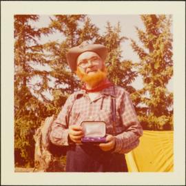
Item is a photograph of Alex Moffat dressed as a prospector holding gold nuggets he salted into a gravel bed and later panned out and gave to Princess Margaret.
Map reproduction depicts major areas of the Aleza Lake Experiment Forest.
Slide depicts the original wooden BC Forest Service sign for the Aleza Lake Forest Experiment Station.
Map reproduction of the Aleza Lake Research Forest depicts timber sale areas, forest cover, and other details.
Photograph depicts a view of the river shore, a few scattered buildings and tents are near the shore. A footpath leads from the water's edge between the dwellings and through the newly cleared land.
Photograph depicts twenty-eight or more people standing on the river's edge, a stack of wood is ready for loading on the steamer that is anchored near the shore.
Slide depicts a black bear eating garbage by wooden outbuildings, possibly at the Aleza Lake Experiment Station.
Slide depicts a bulldozer clearing ground, likely at the Aleza Lake Experiment Station.
Photograph depicts several canvas tents set in lush vegetation near dusk.
Photograph depicts a view from the river looking at the river bank. There is a canvas tent with forest in the background.
Photograph depicts four men paddling a long canoe. The canoe is loaded with supplies and a dog, river and forest in the background.
Photograph depicts six men standing outside a small log building. A sawhorse in the foreground, a tall pole "cache" and forest in the background.
Slide depicts a cleared area at the Aleza Lake Experiment Station with plant regeneration.
Slide depicts a cleared area in a forest, likely at the Aleza Lake Experiment Station.
Slide depicts a detonation in an area of cleared ground in a forested area, likely the Aleza Lake Experiment Station. Work may have been undertaken for roadbuilding activities at the Experiment Station.
Photograph depicts four men pulling a long canoe across a clearing on a wheeled trailer.
Photograph depicts a tarp spread out on the grass, two men sit nearby the tarp. There is a canvas tent in the background with a man standing beside it. Behind the tent is a low hill with a fence bordering the top of the hill. There are blankets drying on the fence.
Photograph depicts several people in a large field. There are buildings and trees in the background.
Slide depicts a heavily forested area with fallen logs, likely at the Aleza Lake Experiment Station.
Photograph depicts four men pinning a "Union Jack" flag to the exterior of a building.
Photograph depicts view of the river from a boat. There is a silhouette of a person wearing a hat in the foreground.
Photograph depicts a wide expanse of river in the foreground looking across the water to a narrow clearing along the opposite riverbank. A few building are scattered across the clearing. There is forest in the background.
Photograph depicts a view from a hill of a river winding through the forest with marshlands nearby.
Photograph depicts a view from a hill of a river winding through the forest with marshlands nearby. This may be a double exposure and there is an indiscernible image in the center of the photo.
File consists an audio recording of an oral history with Harry Coates recorded by Barbara Coupe.
Photograph depicts nine or more people watching a steamer navigate the rough waters of Fort George Canyon from the river shore.
Photograph depicts the rough waters and rocks at Fort George Canyon.
Slide depicts a man operating heavy equipment in a forest, likely at the Aleza Lake Experiment Station.
Photograph depicts a large white building surrounded by a fence.
Image depicts the Lakeland Sawmill in Prince George, B.C, identified by the beehive burners; the one with white smoke belonged to Pas Lumber Co. which was bought out by Lakeland in 1987.
Image depicts the Lakeland Sawmill in Prince George, B.C.
Photograph depicts one man standing on the bank of a river, forest in the background. The image is not in focus or possibly a double exposure.
Photograph depicts a cluster of wooden buildings including a flagpole and church spire at a Lheidli T'enneh village site. Original photo identified this image as "Indian Village, Fort George".
Image depicts an area undergoing logging somewhere in Prince George, B.C.
Photograph depicts a man bathing himself while standing in a small metal tub. Photograph description in album notes this as "His 'Semi Annual'" [bath]. On the left is a log structure, presumably a cache building. A large clearing surrounds the building and bathing man. There is a forest and bluff in the background. Possibly located near Giscome Portage.
Forest cover map showing a crossing area of the McGregor River is annotated with a road and ferry crossing.
Large-format map depicts the Monkman Public Sustained Yield Unit (PSYU) east of Prince George.
Large-format map depicts the Monkman Public Sustained Yield Unit (PSYU) and Tree Farm Licence 30 east of Prince George.
Photograph depicts a view from a high hill, looking down on the Nechako river. There is forest and low rolling hills in the background.
Photograph depicts a view from a high hill looking down on the Nechako river. There is forest and low rolling hills in the background.
Photograph depicts eighteen or more canvas tents scattered on the river shore next to rough cabins and an outhouse.
Large-format map depicts Northwood Pulp & Timber operating areas in 1975.
Image depicts the Northwood pulpmill in Prince George B.C.
Image depicts the Northwood Pulpmill in Prince George, B.C. taken from above the Nechako River looking east. Map coordinates 53°56'00.0"N 122°44'29.7"W
Image depicts the Northwood pulpmill in Prince George B.C.
Photograph depicts several men standing on the river bank. Possibly A.H. Holland in center of photo.
Image depicts Prince George, possibly with the Northwood Pulpmill in the background.