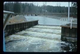
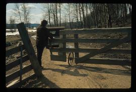
Image depicts an individual opening the gate at Nautley in Fort Fraser, B.C.
Photograph depicts a river or lake, and opposite shore in background. A garden can be seen behind fence in foreground.
Image depicts the sign to Gang Ranch, located in the Upper Fraser Canyon, with graffiti on it.
Image depicts the Gang Ranch office.
Image depicts the Gang Ranch house.
Image depicts a wooden structure at Gang Ranch. It is possibility an elevated water trough.
Image depicts the Upper Fraser Canyon from what appears to be the entrance to Gang Ranch.
Image depicts Gang Ranch, with a sign warning that the area is patrolled by Range and Logging Patrols, in the Upper Fraser Canyon.
Image depicts the Gang Ranch House in the Upper Fraser Canyon.
Image depicts a fence and the property of the Gang Ranch.
Image depicts a view of the property of the Gang Ranch.
Image depicts the house of the owner of Gang Ranch.
Image depicts an area of hill at Gang Ranch.
Image depicts the general store and post office on Gang Ranch.
Image depicts the Fraser River, and a sign pointing towards Gang Ranch, in the Upper Fraser Canyon.
Image depicts the Fraser River, and a sign pointing towards Gang Ranch with an unknown individual hugging it, in the Upper Fraser Canyon.
Image depicts a stream and field at Gang Ranch in the Upper Fraser Canyon.
Image depicts a road near or on Gang Ranch in the Upper Fraser Canyon.
Image depicts Gang Ranch in the Upper Fraser Canyon.
Image depicts two women sitting on a fallen tree on the shore of a lake, possibly Portage Lake; the woman in blue is "Gail," and the woman in red is Sue Sedgwick.
Image depicts a woman named "Gail" on a trail to Portage Lake.
Photograph depicts two log buildings in fenced area on lake shore, forest trees in background. A man can be seen standing near docking area and small boat pier extending into water in foreground. Handwritten annotation on recto of photograph: "Fur Farm Red Rock Lake". This location is believed to at mile 27, north of Summit Lake.
Photograph depicts a group of men, women, and children walking across beach towards water. Buildings visible on shore in left background.
Handwritten annotation on verso reads: "Funeral party - en route to boat Metlakatla BC (Taking body over to Grave Island".
Elevated street view of Fulton Street in Prince Rupert, BC. City Hall is in the left foreground. Hills and water are visible in the background. Printed annotation on recto reads: "Fulton St. Prince Rupert. B.C. W.W.W."
Image depicts a number of people standing at what appears to be a farm fishery [?] on the Fulton River.
Image depicts the entrance of the Fulton River.
Image depicts the Fulton River.
Street view photograph taken at the intersection of Front Street and Carson Avenue. Several men are gathered at Cowan's Hardware store on the corner. Also visible in this photograph is the Cariboo Hotel (visible furthest to the left), and the British American Hotel which is partially visible behind the J.A. Fraser store. Printed annotation on recto reads: "On Front Street, Quesnel, B.C."
Handwritten annotation on recto of photograph: "Front St. Hazelton in Winter. 12 J.W. [...]" Tree line, field, and hills in background. Handwritten annotation on verso of photograph: "Miss. Nellie [Nelville] G. Caranaugh".
Image depicts the area surrounding Tabor Mountain. Prince George is slightly visible on the left side of the image in the background.
Image depicts the area surrounding Tabor Mountain. Prince George is slightly visible in the background.
Image depicts a view of the landscape surrounding Tabor Mountain in Prince George, B.C.
Photograph depicts two men preparing to load a canoe on a wagon. Two blanketed horses stand nearby with one person attending. There is a lake in the background, wild grasses and brush in the foreground.
Image depicts a view of the Sugarbowl Grizzly Den Protected Area from Raven Peak.
Image depicts a view of the Sugarbowl Grizzly Den Protected Area from Raven Peak. The slide itself is labelled "towards cabin."
Image depicts a view of Prince George from Carney Hill.
Photograph depicts 2 large covered wagons pulled by a team of six horses, dry vegetation in the foreground & background.
Image depicts the small town of Fraser, B.C. Located on the Klondike Highway.
Image depicts the Fraser Valley, looking north, possibly from Marguerite, B.C.
Photograph depicts a large river from a bird's eye view, forest and rocks on the water's edge, snow capped mountains in the background.
Photograph depicts view from a high mountain ridge. There is a river valley and clouds in the distance.
Photograph depicts lush forest growth, a tent or tarp is set up on the left of the photo.