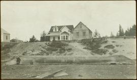
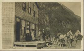
View of 5 buildings and 4 tents on land that has been cleared to stumps. Printed annotation on verso reads: “HAMILTON AVE. FORT GEORGE”, added handwritten annotation in ink reads: “1910”.
Image depicts a hallway in an unknown building somewhere in Wells, B.C.
Image depicts a house on Blackwater Road.
Image depicts an old, half-collapsed building at an uncertain location.
Handwritten annotation on verso of photograph reads: "Tombs. ? Massett".
Caption under printed version of photo in W.H. Collison's book 'In the Wake of the War Canoe': "At Masset, Queen Charlotte Islands, B.C. The side-posts are solid and sunk in the ground. The horizontal piece is hollow, and contains the corpse. These tombs are now falling through decay." (see page 216).
Handwritten annotation on verso of photograph reads: "No. 54. Old tombs & totems. / to Haida graves Massett".
Two tombs stand in foreground, each consisting of a horizontal box held by two hollow posts sunk in the ground.
Photograph depicts an unidentified individual leaning against a large overturned dugout canoe; barrel, bucket, and wood planks in foreground. Houses and other buildings can be seen on shore above beach, and two unidentified individuals stand in distance on far right.
Handwritten annotations on verso read: “Haida canoe on beach at Masset / ? 1898”; “No. 4 Page 5. Haida Canoe ready for steaming to [widen?] out and finish.”
An original negative of this photograph is held by the Canadian Museum of Civilization, no. 26664.
Photograph of the dirt road leading to Hagwilget Village. Residential buildings and a church are visible in the background. Printed annotation on recto reads: "W.W.W. Hagwilget Village."
Photograph depicts the wooden Hagwilget Bridge spanning a rocky gorge over the Bulkley River. Forested area visible in the background. Annotation on recto of photograph states: "W.W.W. Old Indian Bridge, Bulkley River"
Close view of bridge built with wooden planks, poles, and wires, braced from below, with triangles built into its frame. The bridge crosses Hagwilget Canyon on the Bulkley River, five kilometres from its confluence with the Skeena River. This is one of the many bridge structures that have crossed this location since at least 1859. Photograph was taken from one side of canyon, near bridge. Opposite canyon wall in background. Typed annotation glued to verso of photograph: "HAGWILGET - 'the gentle or quiet people'."
Photograph depicts two men and a horse on a bridge built with wooden planks, poles, and wires, braced from below, with triangles built into its frame. The bridge crosses Hagwilget Canyon on the Bulkley River, five kilometres from its confluence with the Skeena River. This is one of the many bridge structures that have crossed this location since at least 1859. Photograph was taken from a distance. Rocky riverbank in foreground, opposite shore in background behind bridge. Typed annotation in red ink on verso of photograph: "INDIAN BRIDGE, NEAR HAZELTON, B.C."
Photograph depicts bridge built with wooden planks and poles, braced from below, with triangles built into its frame. The bridge crosses Hagwilget Canyon on the Bulkley River, five kilometres from its confluence with the Skeena River. This is one of the many bridge structures that have crossed this location since at least 1859.
Handwritten annotation on recto of photograph: "old bridge at the Bulkley River."
Image depicts a church on a hill in Hagwilget, B.C.
Image depicts a bridge in Hagwilget, B.C.
Image depicts machinery in the GTP roundhouse in Prince George, B.C.
Image depicts the interior of the GTP roundhouse in Prince George, B.C.
Image depicts the Grand Trunk Pacific railway roundhouse in Prince George, B.C.
Image depicts the GTP roundhouse in Prince George, B.C.
Image depicts the Grand Trunk Pacific railway roundhouse in Prince George, B.C.
Photograph depicts a group portrait of Iona Campagnolo with construction workers at a building site, possibly for a Young Canada Works project.
Photograph depicts a group portrait of Iona Campagnolo with construction workers laughing at a building site, possibly for a Young Canada Works project.
Image depicts a group of individuals standing on the corner of 3rd Ave in Prince George, B.C.
Image depicts a large group of people in a room at an uncertain location in the Peace River Region.
Photograph is a printed postcard depicting a team of horses harnessed to a buckboard; a group of people standing on a platform outside a building near Stewart B.C. There are mountains in the background.
Photograph depicts large group posed on ceremonial steps in Agora courtyard at the University of Northern British Columbia in Prince George, B.C. Most individuals in group wear regalia. Bridget Moran appears to be standing in center of second row, hand raised to her face.
Group of eight men and seven children stand in front of crest pole on unidentified building.
Handwritten annotation below image reads: "[..?] Alaska. Indian Totem Pole, Eagle Crest South Eastern Alaska."; on verso: "Chapter XXI Illustrations No. 2. [Kinnanook?] Section of Indian Village showing Totem pole of Eagle crest."
Photograph depicts small buildings with canvas roofs and signs reading: "Do Drop In, Ladies & Gents Furnishings Boots & Shoes, Two Per Cent Beer." One woman, nine men,and three dogs can be seen in image.
Handwritten annotation on verso: “Prairie Creek 1912".
Photograph depicts group of working men and 6 dogs standing outside wood building. Hill in background.
Photograph depicts two women with flowers and three men standing on grass and boardwalk in foreground, large building in background.
Handwritten annotation on verso: “Government Agency at S. Fort George 1922."
Ground level view of the dry dock in Prince Rupert, BC. Printed annotation on recto reads: "Dry Dock Prince Rupert BC McRae Bros."
Ground level view of the Prince Rupert dry dock during what appears to be construction. Printed annotation on recto reads: "The Dry Dock of Prince Rupert."
Photograph depicts a grocery store on the main street of Pitt Meadows in the Fraser Valley.
Photograph depicts the interior of a grocery shop displaying eggs, scale, sides of meat, bananas, other produce and 2 shop attendants. Sign above table reads: Morrow & Frizzell. Handwritten annotation in pencil on recto reads: “Port Essington B. C. 1907”.
Greeting card reads: "Kincolith Church. Wishing you all a very happy Xmas. Your work shall be rewarded. II Chron. XV. 7. [illegible initials]".
Greenhouses stand in front of house in field, hills in background.
Photograph depicts a lighthouse on a rocky island with water in the foreground. Annotation on verso of photograph states: "Dear Dr. Thanks for the cheque received yesterday. Christmas Greetings. Yours Sincerely Mr. Cruickshank (?) Green Island"
Photograph depicts the Great Northern Railway former station at Cascade, just north of the Canada-U.S. border and 15 miles east of Grand Forks. The line connects Kettle Falls and Grand Forks, but the station is now disused but in good repair. The view is looking south towards Washington State.
Photograph depicts the Great Northern Railway depot at Keremeos and the terminus of the line from Wenatchee, Washington, U.S.A. The line stops about 1/3 mile beyond this point. At one time it ran on to Hedley mine and possibly Princeton.
Photograph depicts the rear of the Great Northern depot on Main St. in Vancouver, that is now demolished.
Image depicts a small graveyard at an uncertain location.
Image depicts numerous grave markers at an uncertain location.
Image depicts the grave of W.L. Meason in the upper Fraser Canyon.
Image depicts Grassy Plains, B.C.