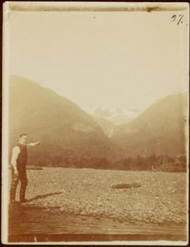
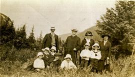
Print preview Close

Showing 21337 results

Archival description
Weyerhaeuser sawmill
2013.6.36.1.145.06 · Item · Aug. 1997
Part of David Davies Railway Collection

Photograph taken on the CPR branch from Vernon to Lumby. Depicts a small Weyerhaeuser sawmill. Looking west at Lumby. The end of the track was another 1/3 of a mile behind the camera.

Westminster
2004.2.1.131 · Item · [between 1910 and 1920]
Part of Reverend R.W. Large fonds

Photograph depicts the boat Westminster on the water with houses on the shoreline visible in the background. Annotation on verso of photograph states: "Westminster"

2013.6.36.1.007.021 · Item · Oct. 1965
Part of David Davies Railway Collection

Photograph depicts the western portal of the C.P.R. Connaught Tunnel under Rogers Pass. The Glacier Station is a quarter mile to the rear of the camera. Fans are operated to force air through the tunnel against the direction of the trains, these therefore used for all westbound traffic. Diesel driven, steam for ancillary equipment.

Westbridge CPR depot
2013.6.36.1.027.14 · Item · [July 1966]
Part of David Davies Railway Collection

Photograph depicts the Westbridge CPR depot on the Kettle Valley Line. It is located about 11 miles north of Rock Creek and at about mile 123.3 east of Penticton. The depot house is disused and the sidings contained no cars, so there appears to be no local traffic.

West Summerland CPR station
2013.6.36.1.022.14 · Item · 2 Sept. 1970
Part of David Davies Railway Collection

Photograph depicts the West Summerland CPR station in the Okanagan. The station often was used but not permanently manned. It was located at mile 9.5 from Penticton. The view is looking south.

West Summerland CPR station
2013.6.36.1.022.15 · Item · 2 Sept. 1970
Part of David Davies Railway Collection

Photograph depicts the West Summerland CPR station in the Okanagan, located 9.5 miles from Penticton. The cloud in the middle distance is stone dust from a crusher on the east side of the track. The spur to the right leads to an old crusher but does not appear to be used.

2023.2.2.13.2.08 · Item · 8 Jul. 2007
Part of Dr. Paul Sanborn fonds

This image is part of the outbound sequence of aerial images obtained on the helicopter flight to the Klutlan Glacier study site. The sequence starts from the base camp at the White River crossing on the Alaska Highway and heads south, to a point just upvalley of the debris-covered terminus (approx. 10-15 km from Alaska border), and turning back north to the landing spot on the Generc River floodplain close to the study site (see Fig. 1 in paper).

2023.2.2.13.2.09 · Item · 8 Jul. 2007
Part of Dr. Paul Sanborn fonds

This image is part of the outbound sequence of aerial images obtained on the helicopter flight to the Klutlan Glacier study site. The sequence starts from the base camp at the White River crossing on the Alaska Highway and heads south, to a point just upvalley of the debris-covered terminus (approx. 10-15 km from Alaska border), and turning back north to the landing spot on the Generc River floodplain close to the study site (see Fig. 1 in paper).

2023.2.2.13.2.26 · Item · 8 Jul. 2007
Part of Dr. Paul Sanborn fonds

This image is part of the outbound sequence of aerial images obtained on the helicopter flight to the Klutlan Glacier study site. The sequence starts from the base camp at the White River crossing on the Alaska Highway and heads south, to a point just upvalley of the debris-covered terminus (approx. 10-15 km from Alaska border), and turning back north to the landing spot on the Generc River floodplain close to the study site (see Fig. 1 in paper).

2023.2.2.13.2.27 · Item · 8 Jul. 2007
Part of Dr. Paul Sanborn fonds

This image is part of the outbound sequence of aerial images obtained on the helicopter flight to the Klutlan Glacier study site. The sequence starts from the base camp at the White River crossing on the Alaska Highway and heads south, to a point just upvalley of the debris-covered terminus (approx. 10-15 km from Alaska border), and turning back north to the landing spot on the Generc River floodplain close to the study site (see Fig. 1 in paper).

2023.2.2.13.2.28 · Item · 8 Jul. 2007
Part of Dr. Paul Sanborn fonds

This image is part of the outbound sequence of aerial images obtained on the helicopter flight to the Klutlan Glacier study site. The sequence starts from the base camp at the White River crossing on the Alaska Highway and heads south, to a point just upvalley of the debris-covered terminus (approx. 10-15 km from Alaska border), and turning back north to the landing spot on the Generc River floodplain close to the study site (see Fig. 1 in paper).

2023.2.2.13.2.50 · Item · 9 Jul. 2007
Part of Dr. Paul Sanborn fonds

This image is part of the return trip sequence of aerial images obtained on the helicopter flight leaving the Klutlan Glacier study site. On the return leg at the end of the day, the flight initially went upvalley to pick up another party.

2023.2.2.13.2.25 · Item · 8 Jul. 2007
Part of Dr. Paul Sanborn fonds

This image is part of the outbound sequence of aerial images obtained on the helicopter flight to the Klutlan Glacier study site. The sequence starts from the base camp at the White River crossing on the Alaska Highway and heads south, to a point just upvalley of the debris-covered terminus (approx. 10-15 km from Alaska border), and turning back north to the landing spot on the Generc River floodplain close to the study site (see Fig. 1 in paper).

2023.2.2.13.2.51 · Item · 9 Jul. 2007
Part of Dr. Paul Sanborn fonds

This image is part of the return trip sequence of aerial images obtained on the helicopter flight leaving the Klutlan Glacier study site. On the return leg at the end of the day, the flight initially went upvalley to pick up another party.

2023.2.2.13.2.52 · Item · 9 Jul. 2007
Part of Dr. Paul Sanborn fonds

This image is part of the return trip sequence of aerial images obtained on the helicopter flight leaving the Klutlan Glacier study site. On the return leg at the end of the day, the flight initially went upvalley to pick up another party.

West side of Generc River
2023.2.2.13.2.10 · Item · 8 Jul. 2007
Part of Dr. Paul Sanborn fonds

This image is part of the outbound sequence of aerial images obtained on the helicopter flight to the Klutlan Glacier study site. The sequence starts from the base camp at the White River crossing on the Alaska Highway and heads south, to a point just upvalley of the debris-covered terminus (approx. 10-15 km from Alaska border), and turning back north to the landing spot on the Generc River floodplain close to the study site (see Fig. 1 in paper).

Wells Hospital building
2012.13.1.37.23 · Item · 1978
Part of J. Kent Sedgwick fonds

Photograph depicts the old hospital building in Wells. At the time the photo was taken, 1978, it was being used as an apartment building, and that is still its current use.