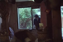
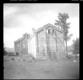
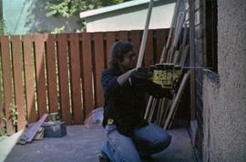
Photograph depicts an unknown man with a chainsaw cutting a window frame in a house under construction.
Image depicts an unidentified man standing on a wood bridge somewhere in South Tweedsmuir Provincial Park.
Handwritten annotation on recto of photograph: "Frank [Johnstron?] Oct. 13th/11 Hazelton BC". Photograph depicts Frank sitting in suit and hat with dog on a wood walkway, unidentified building in background on left. Wood pile is visible behind them.
Photograph depicts a man installing a window in a house under construction. Photograph taken from the interior of the house.
Photograph depicts man standing among six snow-covered buildings in what is believed to be a railway construction camp. Power line in foreground, forest trees in background.
Unknown man sits on steps of building.
Unidentified man stands in front of hedges. Small bush in foreground, tall home and trees in background. Handwritten annotation on recto of photograph: "Noisy in the Garden."
Photograph depicts lane in front of tent buildings flooded with water, and a man standing near doorway to first building. It is believed that this photograph may depict the Island Cache in flood, at Prince George, BC.
Snow and trees can bee seen on opposite shore in background. Sign posted at top of bridge reads: "NOTICE. ANY PERSON OR PERSONS DRIVING OVER BRIDGE AT A PACE FASTER THAN A WALK WILL BE [?] BY [?] DISTRICT FRONTIER".
Photograph depicts man walking on four long logs across flowing water, rocks and bush on opposite shore in background. Handwritten annotation on recto of photograph: "Canyon Creek Sourdough McKay".
Photograph depicts unidentified man with large carcass tied to his back standing in front of wood shed. A second building can be seen behind fence in background.
Cane floats in flooded area of camp, tent buildings and forest trees in background. It is believed that this photograph may depict the Island Cache in flood, at Prince George, BC.
Man stands by doorway of large house. Sidewalk, front lawn, and palm trees in foreground. Photograph speculated to have been taken in Los Angeles, California.
Photograph depicts man standing in front of elevated, rectangular cache made of wood. Trees stand behind log fence in background. Handwritten photo caption below photograph reads: "Indian Cache." It is believed that this photograph may have been taken near Fort St. James, BC.
Image depicts a man, possibly Kent Sedgwick, standing next to a monument which states: "In honour of the pioneers of the Ootsa Lake Valley, first settled in 1905." Located somewhere in either the Francois Lake Provincial Park or the Wistaria Provincial Park.
Photograph depicts unidentified man and dog laying on bed in bunkhouse. Miscellaneous items can be seen on table in background beside window. Handwritten caption beside this photo reads: "Bunkhouse".
Photograph depicts two women and one man standing in snowy street behind loaded sled pulled by three large dogs. Unidentified buildings in background, hill visible in distance. It is speculated that this photograph may have been taken in Atlin, B.C.
Photograph depicts one man and three woman standing in front of shop windows of three story building with the sign "GERMAN. BAKERY. F. TIEMEYER" A window nook and small balcony extend from second floor. Road in foreground. Handwritten annotations on recto of photograph: "Main Building 30 x 32. Lean to for Bake Shop. Food cellar. Five Food Rooms upstairs. Electric lights throughout entire house. Burned badly Jan 15 - 9 45 PM 1969. Was originally moved from South."
Photograph depicts dog standing next to man smoking pipe and leaning against large snow bank (snow stands taller than man). Power lines connect to wood building standing in background. Photograph believed to have been taken in railway construction camp.
Photograph depicts the Malahat station on the Esquimalt and Nanaimo Railway line, 20 miles north of Victoria on Vancouver Island. The view is looking south and there are no houses anywhere in the vicinity.
Photograph depicts the Malahat Station on the Esquimalt and Nanaimo Railway on Vancouver Island. The view is looking south towards Victoria.
People, cars, and trucks visible on street, buildings in background. Handwritten annotation on verso reads: “P. Rupert Main Street British Columbia Canada, McRae Bros".
Photograph depicts Mainland St. in Vancouver, B.C. , looking northeast with Helmken St. intersecting.
Street view photograph of buildings along the dirt road of Main Street in Smithers, B.C." Printed annotation on recto reads: "Main St. Smithers B.C." Handwritten annotation in pen on verso reads: "Town 7 miles from my place."
Hand coloured photo of Main Street in Prince Rupert, with various tents and buildings on either side of the wooden road. Printed annotation on recto reads: "Main Street, Prince Rupert, B.C. : On comparatively Level Line London to Yokohama." Artist's mark on lower right corner reads: "104,035 J.V."
Photograph depicts the main street of Rolla with a dirt street and wooden sidewalks, tethered horses, and the storefront of H.G. Atkinson General Merchants. Three people are visible walking through the streets.
Image depicts several buildings along the main street in Stewart, B.C. One of them has been boarded up.
Image depicts several buildings along the main street in Stewart, B.C.
Image depicts the main street of Stewart, B.C.
Typed annotation on recto: "Main building of Douglas Lodge, Stuart Lake, B.C." Men and a woman stand beside an automobile parked outside the main building.
Image depicts numerous vehicles in the parking lot of a mall in Mackenzie, B.C.
Image depicts the Mackenzie Curling Rink.
Image depicts a small section of Mackenzie, with the Mackenzie Curling Rink visible on the right side of the image.
Image depicts numerous vehicles parked outside a building with a sign which reads "Mackenzie Centre;" it is possibly the mall in Mackenzie, B.C.
Image depicts a trailer park somewhere in Mackenzie, B.C.
Image depicts a trailer park in Mackenzie, B.C.
Image depicts a row of houses in Mackenzie, B.C.
Image depicts numerous individuals wearing hard hats in what appears to be a computer room somewhere in Mackenzie, B.C.
Image depicts numerous individuals examining a map as they are seated around a table. The location of the meeting is somewhere in Mackenzie, B.C.
Image depicts numerous individuals seated around a table and apparently having a meeting at an uncertain location in Mackenzie, B.C.
Image depicts numerous individuals inside a mall in Mackenzie, B.C.
Image depicts a row of houses in Mackenzie, B.C.
Image depicts several apartment buildings and the sign for a Gulf Gas Station in Mackenzie, B.C.
Image depicts numerous condominiums somewhere in Mackenzie, B.C.
Photograph depicts a Lutheran Church on River Rd. in north Surrey, opposite from Annacis Island.
Photograph depicts Lund Harbour, looking north, 12 miles north of Powell River. It is the most northerly point on the mainland accessible by car, on this part of the coast. Lund is 92 car miles north of the ferry terminal at Langdale.
Photograph depicts all that remained of Lumberton Spruce Mills Ltd, circa 1912-1939.
Photograph depicts pile of cut logs in right foreground, unknown building and forest in background. Logs lie in front of what appears to be a large freight box.