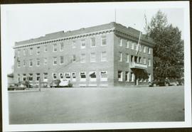
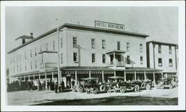
Photograph depicts hotel on corner of street, crowd and cars in foreground.
Handwritten annotation on verso “Albert Johnson’s 'Northern Hotel' South Fort George 1914".
Photograph depicts hotel on corner of street, crowd and cars in foreground.
Handwritten annotation on verso “Albert Johnson’s 'Northern Hotel' South Fort George 1914".
Photograph depicts four men pulling a long canoe across a clearing on a wheeled trailer.
Image depicts a long line of people cross country skiing somewhere on Tabor Mountain in Prince George, B.C.
Image depicts an unidentified man cross country skiing somewhere on Tabor Mountain in Prince George, B.C.
Photograph depicts large three story building, road and parked cars in foreground.
Annotation on verso: “Court House and Prov. Govt. offices at Pr. George. Once used to be 'Alexandra Hotel' now site occupied by Kresge’s. Alexander Hotel. Opened Sept 25, 1915."
Photograph depicts man and woman speculated to be Pat (Bridget Moran's son) and Tracy holding food and beverage on deck in backyard. Unidentified individuals semi-visible on far left and right. Trees and building visible in background. Photo taken on the day Bridget Moran received an Honourary Law Degree from the University of Northern British Columbia in Prince George, B.C.
Image depicts a the Cottonwood Island Nature Park sign and map in Prince George, B.C.
Image depicts Elmer Mercier, a former mayor of Prince George, B.C., cutting the ribbon to open Cottonwood Park's Heritage Trail.
Image depicts a crowd of people in Cottonwood Park in Prince George, B.C.
Image depicts a nature trail in Cottonwood Island Park by a beehive burner. Map coordinates 53°55'23.6"N 122°43'53.8"W
Image depicts a couple walking through a nature trail in Cottonwood Island Park. Map coordinates 53°55'23.6"N 122°43'53.8"W
Image depicts Cottonwood Island.
Image depicts a section of the Heritage Trail on Cottonwood Island in Prince George, B.C.
Street view of some vehicles parked in front of commercial buildings in Prince/Fort George. Businesses include "J.P. Robertson 'The Men's Store'" and "James & Co. Clothing and Shoes." Printed annotation on recto reads: "Fort George- Corner Hammond and Central."
Slide depicts a detonation in an area of cleared ground in a forested area, likely the Aleza Lake Experiment Station. Work may have been undertaken for roadbuilding activities at the Experiment Station.
Photograph depicts pier under construction, workers, buildings smokestacks and river with chunks of ice. Handwritten annotation in pencil on recto reads: “S. FT. GEORGE G.T.P. BRIDGE”.
Image depicts the Columbus Hotel in Prince George, which was destroyed by a fire in 2008.
Item is a hand drawn and coloured map by the City of Prince George Planning Department depicting the College Heights and southwest (Vanway) neighbourhood area existing land use in 1976.
Image depicts College Heights, particularly along Gladstone Drive, in Prince George, B.C.
Street view photograph of a large brick with a vehicle parked in front. Printed annotation on recto reads: "C.N.R. Station Prince George, B.C."
Photograph depicts a bridge at the east end of the CNR yards in Prince George, crossing the Fraser River.
Photograph depicts the CNR depot in Prince George. To the right area of the photograph lay the downtown area of the city.
Photograph depicts the CNR depot. Considerable renovation work was taking place on both sides of the building and in the interior nearest to the camera.
Photograph depicts a rail bridge over the Fraser River. Canter levelled on both sides were vehicle roadways which ceased to be used in 1987 when a new road bridge was supposed to be completed. The right lane took cars into the city of Prince George.
Photograph taken somewhere between Endako and Prince George, Nechako Subdivision.
Photograph taken somewhere between Prince George and McBride.
Image depicts a number of trains in the CNR train yard taken from River Road in Prince George, B.C. Map coordinates 53°54'51.5"N 122°43'29.6"W
Photograph depicts a CN bridge crossing over the Fraser River. Built by Grand Trunk Pacific Railway in 1914.
Photograph depicts a CN bridge crossing over the Fraser River.
Photograph depicts a CN bridge crossing over the Fraser River. Built by Grand Trunk Pacific Railway in 1914.
Photograph depicts a CN bridge crossing over the Fraser River.
Photograph depicts a CN bridge crossing over the Fraser River. Details of the draw span captured.
Photograph depicts a CN bridge crossing over the Fraser River.
Photograph depicts a print taken fron a slide supplied by a professional photographer, Al Harvey. Captures a CN bridge crossing over the Fraser River.
Photograph depicts a CN bridge crossing over the Fraser River. It used to be a public roadway for eastbond traffic only.
Photograph depicts a CN bridge crossing over the Fraser River. Built by Grand Trunk Pacific Railway in 1914.
Photograph depicts a CN bridge crossing over the Fraser River.
Photograph depicts a CN bridge crossing over the Fraser River. Built by Grand Trunk Pacific Railway in 1914.
Photograph depicts a CN bridge crossing over the Fraser River.