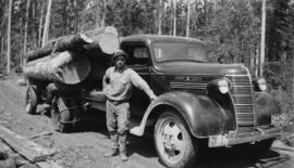
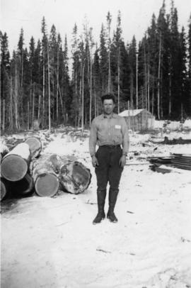
Photograph depicts Cornel Neronovitch at a Peden Hill sawmill. Caption on back of photograph states: "Cornel Neronovitch".
Photograph depicts Cornel Neronovitch standing by a 'Maple Leaf' Chevrolet truck near the Peden Hill sawmill. Raw logs are stacked and chained on the truck.
Photograph depicts the corner building on West Georgia and Chilco St., facing Stanley Park in Vancouver B.C. View looking south across Georgia St.
Photograph depicts a corner building on Chilco and West Georgia St. facing Stanley Park in Vancouver, B.C. The view is looking east across Chilco St.
Street scene depicts people, boardwalks, and buildings with store signs. Rubble and unknown material lies on ground between boardwalks. Printed annotation on recto reads: “3rd Ave. and 6th St. Prince Rupert. B.C.”
Photograph taken from a low elevation of various businesses in Stewart, BC. Visible businesses include "The R. Boyd Young Co." and "Motel King Edward." Printed annotation on recto reads: "Cor. 5th and Columbia Sts. Stewart. B.C. Hughes #45."
Photograph taken from a low elevation of various businesses in Stewart, BC. Visible businesses include "The R. Boyd Young Co." and "Motel King Edward." Printed annotation on recto reads: "Cor. 5th and Columbia Sts. Stewart. B.C. Hughes #44."
Image depicts the corner of a log house at an unknown location.
Image depicts the corner of a log house, the slide itself labels the picture as being from Barkerville, B.C. and also indicates the corner is an example of a "round log" dovetail joint.
Street view of some vehicles parked in front of commercial buildings in Prince/Fort George. Businesses include "J.P. Robertson 'The Men's Store'" and "James & Co. Clothing and Shoes." Printed annotation on recto reads: "Fort George- Corner Hammond and Central."
Photograph depicts a street scent at the corner of Laselle and Second St. in Fort George. A wagon is visible in the dirt road and wooden buildings cross the mid ground. Three unidentified men sit on the boardwalk outside Rigg's Restaurant while one man stands in the doorway of The White Laundry.
Corporate Office - General.
Image depicts a rail road bridge, possibly the Cottonwood Bridge, at an uncertain location.
Image depicts the Cottonwood Bridge.
Image depicts a view of a river from the Cottonwood Bridge.
Image depicts a forest; the image is possibly taken from somewhere near the Cottonwood Rail Road Bridge.
Photograph depicts a narrow canyon on the Fraser River.
Photograph depicts a steamboat on the Fraser River with a full view of the paddles.
Image depicts the Cottonwood Canyon.
Photograph depicts a steamboat on the Fraser River.
Photograph depicts a view of rough river waters from the deck of a steamboat.
Typed annotation on recto: "Cottonwood dugout on Tachi River Stuart Lake Section of B.C." Two people sit in dugout canoe, tree-covered banks in background.
Image depicts a section of the Heritage Trail on Cottonwood Island in Prince George, B.C.
Image depicts the Cottonwood House at the Historic Site located in Barkerville, B.C.
Image depicts the Cottonwood House.
Image depicts the Cottonwood House Historic Site along Barkerville Highway, east of Quesnel, B.C. A sign posted by the fence reads: "For over half a century the Boyd family operated this haven for man and beast. Here weary travellers found lodging, food, and drink. Here fresh horses were hitched to stage-coaches and miners bought supplies. This historic road-house, built in 1864, stood as an oasis of civilization on the frontier of a rich new land."
Image depicts the kitchen area of the interior of the Cottonwood House.
Image depicts the living area of the interior of the Cottonwood House.
Image depicts the picnic site of the Cottonwood House Historic Site, located on the Barkerville Highway, east of Quesnel, B.C.
Image depicts Cottonwood Island.
Image depicts a nature trail in Cottonwood Island Park by a beehive burner. Map coordinates 53°55'23.6"N 122°43'53.8"W
Image depicts a couple walking through a nature trail in Cottonwood Island Park. Map coordinates 53°55'23.6"N 122°43'53.8"W
Image depicts a crowd of people in Cottonwood Park in Prince George, B.C.
Image depicts Elmer Mercier, a former mayor of Prince George, B.C., cutting the ribbon to open Cottonwood Park's Heritage Trail.
Image depicts a the Cottonwood Island Nature Park sign and map in Prince George, B.C.
Photograph depicts large bridge and dam over a wide river, industrial structures throughout. Hills on opposite shore in background. Handwritten annotation on recto of photograph: "Coulee Dam, This is were[sic] I went this fall. Wished you had of been with me."