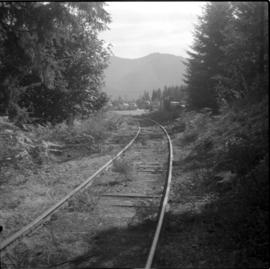
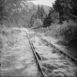
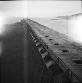
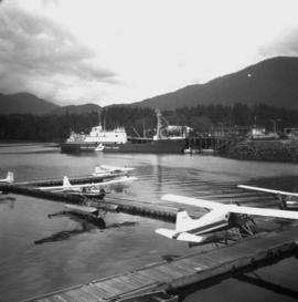
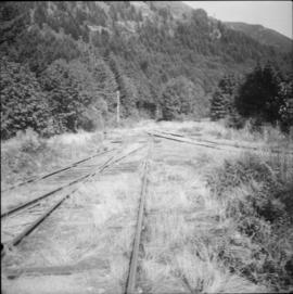
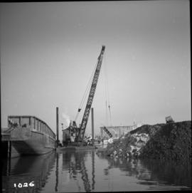
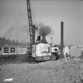
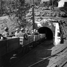
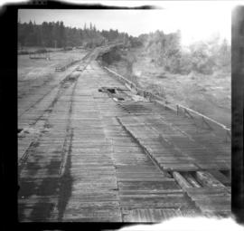
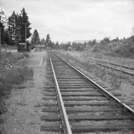
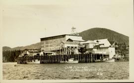
Photograph taken at the end of the branch line from Cowichan Bay to the BC Forest Products Mill in Youbou.The spur on the right was the second of 2 rail entrances to the mill and was the one that was most often used.
Photograph depicts a private spur leading to the BC Forest Products Mill.
Photograph depicts a switch found in the immediate foreground that lead to a totally overground "Y" on the right.
Photograph depicts a coach stock in the C.P.R. False Creek yards in Vancouver, B.C.
Photograph depicts Coal Harbour in Vancouver. The view is looking east.
Photograph depicts Coal Harbour in Vancouver. The view is looking east at the Bayshore Hotel and facing the Harbour Park Development site, newly filled with rock.
Photograph depicts Coal Harbour in Vancouver. The photo was taken nearly at the head of the harbour on the south side.
Photograph depicts a general view of Coal Harbour in Vancouver, taken from its head in Stanley Park, looking east. The Bayshore Inn is shown on the extreme left of the image.
Photograph depicts the upper end of Coal Harbour, on the south shore looking southwest and taken from the dock of the Vancouver Shipyards Ltd.
Photograph depicts a general view of Coal Harbour in Vancouver, looking southeast and taken from Royal Vancouver Yacht Club premises. Photo shows the Bayshore Hotel on the extreme left.
Photograph depicts the west end of Coal Harbour looking south to West Georgia St. and Chilco-Gilford block beyond. The old pilings exposed at low tide.
Photograph depicts a general view of the upper and south shore section of Coal Harbour in Vancouver, B.C.
Photograph depicts a general view of the last 300 yards of the upper neck of Coal Harbour in Vancouver, B.C. The view is looking west and taken from the south side.
Photograph depicts the west end of Coal Harbour looking south to West Georgia St. and Chilco-Gilford block beyond. The old pilings exposed at low tide.
Photograph depicts a general view of Coal Harbour in Vancouver, looking southeast and south with Marine Building (downtown) on extreme left and Stanley Park (unseen) at extreme right.
Photograph depicts the Tsable coal pit on Vancouver Island as the first coal of the afternoon shift being hauled up.
Photograph depicts coal miners near Buckley Bay. The afternoon shift (3 p.m.) is going down the Tsable drift mine, which is the only working coal pit on Vancouver Island in 1964 and has a total of 70 employees. It is run by the Comox Colliery Co. and has a daily production of 200-300 tons.
Photograph depicts coal wharves at the seaward end of the railway that connected with coal mines at Cumberland and Union Bay. Image captured looking northwest with coke ovens located on the right and covered by brush.
Photograph depicts coal wharves of a defunct railway that ran bewteen coallieries at Cumberland and Union Bay. The ground on the left appeared to be filled, recently dumped and bulldozed flat.
Photograph depicts the coaling wharf at Union Bay on Vancouver Island. It is the property of the Canadian Colliery Resources Ltd. It was last used on August 15, 1960. Thereafter, all equipment and railways were dismantled but the water tank is still standing.
Photograph depicts the coast guard crash boat "Moorhen. It is an ex- RCAF rescue launch at Kitsilano Federal wharf, False Creek, Vancouver. Sister ship is the "Mallard."
Photograph depicts the coast guard cutter "Racer" at Burrard Federal Dock in Kitsilano, Vancouver.
Image depicts the coastline of Haida Gwaii, B.C.
Image depicts a view of the coast of Haida Gwaii.
Image depicts an aerial view of the coastline of Haida Gwaii, B.C.
Image depicts a view of the coast of Haida Gwaii.
Image depicts the coastline of Haida Gwaii, B.C.
Image depicts a view of the coast of Haida Gwaii.
Photograph depicts a dock on the left, water, low treed hills in the center of the photo and mountains in the distance.
Image depicts the coastal forests on the shores of Haida Gwaii, B.C.
Image depicts the coastal forests on the shores of Haida Gwaii, B.C. An unknown individual is crouching on the beach in the image.
Image depicts numerous trees in the coastal forest of Haida Gwaii, B.C.
Photograph depicts a view from a water vessel looking toward an inlet and mountains near the shore.
Photograph depicts a coastal shoreline with docked boats and residential area in background.
Photograph depicts a Coastgaurd ship, "Narwhal," at the Department of Transport wharf in Seal Cove.
Photograph depicts the coasting vessel "Hecate Prince" owned by the Northland Navigation Co. Ltd. at their wharf on the southeast side of Vancouver Harbour.
Photograph depicts the Cobble Hill Station on the Esquimalt and Nanaimo Railway on Vancouver Island. The view is looking south.
Item is a photograph of the coffer dam built to isolate the construction site for the W.A.C. Bennett Dam.
Photograph depicts the coking ovens at Union Bay on Vancouver Island. They belong to the Canadian Collieries Ltd. and the date last used is unknown.
Attached description: The operator's cabin is visible behind the Colby 70-ton bridge crane grapples as it lifts a bundle of logs to the breakdown deck. In the background, a boomboat brings another bundle into position for pickup from the holding bay inside the pond formed by the dock.
Water level photograph of several small vessels gathered around a large cold storage building. Printed annotation on recto reads: "Cold Storage, Prince Rupert B.C. 66."
Printed captions below images on recto read: “Souvenir of Prince Rupert BC; Prince Rupert June 1st, 1909; Prince Rupert Sept 1st, 1913; Public School; Water Front; City Hall; Haye Cove; Margaeto Fleet; Harbour Scene; SS Prince Marquitta at Prince Georg; Sunrise Prince Rupert Harbour; General Hospital; Gold Storage Place; Prince Rupert from Summit”.
Captions below images on recto read: “H.M.C.S. Thiepval. Capt Beech.; In surf Recks and Fog. Wikelski Island; The Aeroplane; Major Stuart MacLaren, and party, at Prince Rupert. B.C.; British Around –the –World, Wrecked Aeroplane”.
Collection of four photographs of the Prince Rupert dry dock. Printed annotation on recto reads: "Dry Dock and Ship Building Plant, Prince Rupert BC."
Collection of four photographs of the Prince Rupert dry dock. Two images are the finished dry dock buildings. One image is of construction. Printed annotation on recto reads: "Before Launching Canadian Scottish Dry Dock, Prince Rupert BC."
Image depicts a collapsed cabin in Quesnelle Forks, B.C.