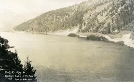
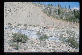
Photograph depicts the Peace River Canyon with the Peace River in the foreground and rocky, tree-lined cliffs flanking the river. In the background a forested mountain base is visible.
Image depicts a street of shops at an uncertain location somewhere in the Peace River Regional District. A pink and blue building, possibly a theatre, is labelled "Lux."
Image depicts grass burning at an uncertain location in the Peace River Region.
Image depicts a section of forest located somewhere in the Peace River Regional District of B.C.
Photograph depicts tent buildings on either side of dirt road. Unidentified men are visible on left, Atlin Lake and mountains can be seen in background.
Hand inscribed annotation on recto of photograph reads: “Pearl Av. looking towards Atlin Lake, Atlin, B.C., A.C. Hirschfeld, No. 174”
Photograph depicts buildings and signage on either side of dirt road. Unidentified man stands on far left, Atlin Lake and mountains can be seen in background.
Hand inscribed annotation on recto of photograph reads: “Pearl St., Atlin, B.C. Aug. 1899. A.C. Hirschfeld, No.74”.
Image depicts a view of Peden Hill in Prince George, B.C.
Item is a map depicting a future high density development plan for the Peden Hill neighbourhood in Prince George.
Item is a map depicting a future low density development plan for the Peden Hill neighbourhood in Prince George.
Item is a map depicting a future medium density development plan for the Peden Hill neighbourhood in Prince George.
Item is a map depicting the areas of spring and fall shadow in the Peden Hill neighbourhood in Prince George.
Item is a map depicting the areas of winter shadow in the Peden Hill neighbourhood in Prince George.
Image depicts rail road tracks and several buildings in Pemberton, B.C.
Image depicts the condominiums in the "Pemberton Valley Estates" in Pemberton, B.C.
Image depicts a beehive burner somewhere in or near Penny, B.C.
Image depicts a red boat on a river, possibly the Fraser, near Penny, B.C.
Image depicts four unidentified individuals standing on the bank of a river, possibly the Fraser, somewhere in or near Penny, B.C.
Image depicts a river, possibly the Fraser, near Penny, B.C.
Image depicts Sue Sedgwick standing in front of an old, run-down house somewhere in or near Penny, B.C.
Photograph depicts two men standing on a wharf. A steamboat is docked, there are rails on the wharf and mountains in the distance.
Image depicts several unidentified individuals and a bridge behind them; it is possibly crossing the Peace River.
Image depicts a group of people heading towards a glacier, possibly the Robson Glacier.
Image depicts a group of people standing on a hill, with what is possibly Mt. Robson in the background.
Image depicts a group of unknown individuals with a mountain in the background.
Image depicts a man talking to a group of hikers, with what is possibly Mt. Robson and the Robson Glacier in the background.
Image depicts a group of people observing splintered wooden boards at an uncertain location.
Image depicts several unidentified individuals standing on a bridge; it possibly crosses the peace River.
Image depicts a group of people standing on the foot of a glacier, possibly the Robson Glacier.
Image depicts a group of people on the rocky bank of a river somewhere near Mt. Robson.
Image depicts an individual, possibly Sue Sedgwick, standing next to a very thick and tall tree somewhere on Haida Gwaii.
Image depicts an individual standing on a trail in the coastal forest on Haida Gwaii, B.C.
Image depicts an individual ducking under a tree branch somewhere in Haida Gwaii, B.C.
Image depicts an individual walking on a a log bridge in a forest somewhere on Haida Gwaii.
Image depicts an individual walking on a path through a forest somewhere on Haida Gwaii.
Photograph depicts men standing on shore near what appears to be a long pier extending into the river. Trees on left, opposite shore in background. Handwritten annotation on recto of photograph: "Pete Joy's Bar Finlay River."
Image depicts an aerial view of areas that have been used for logging around Prince George, B.C.
Image depicts an aerial view of the Ahbau area somewhere near Prince George, B.C.
Image depicts a view of the south direction of the grade for the British Columbia Railway, which was formerly known as the Pacific Great Eastern until 1972. It is at an uncertain location, possibly near Woodpecker or Prince George.
Photograph depicts "Kelly's Lake" (now known as Kelly Lake) in Clinton, as well as the Pacific Great Eastern Railway line along the lake.
Image depicts an unknown woman taking pictures. Nearby are the skeletal remains of an unknown animal. The location is somewhere near the upper Fraser Canyon.
Photograph depicts a woman standing on a step outside a building this woman is tending to a toddler. The building is constructed of chinked logs.
Perspective of pier and wharf as seen from the water. Port Simpson and hill in background. Sternwheeler can be seen on shore.
Perspective of Port Simpson and pier as seen from the water.
Photograph of a large pile driver working on the waterfront at the foot of a forested slope. Printed annotation on recto reads: 'Pile-driver working on Government Wharf Hughes #55."
Image depicts a pile of dead trees in a forest somewhere on Haida Gwaii.
Photograph depicts Pine Creek winding through forest and hills. Altin Lake and mountains in background. Handwritten annotation on recto of photograph: "Atlin: Looking down lower Pine Ck, westerly towards Atlin, Atlin Lk, & the Atlin Mts. (part of Coast Range)."
Image depicts a view of Pine Pass.