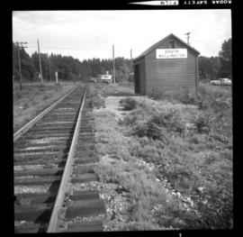
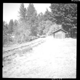
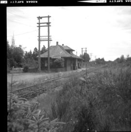
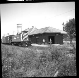
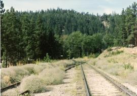
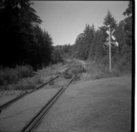
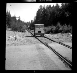
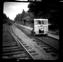
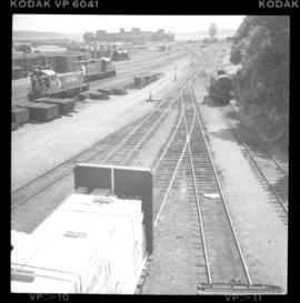
Photograph depicts the Fernie CPR station, located at mile 34.7 on the Cranbrook Subdivision, which runs from Crowsnest to Cranbrook. In coal mining days this was a busy place but now it has sidings for 153 cars and nothing else. The view is looking east.
Photograph depicts the Federal Railway Bridge in New Westminster. Its span had been knocked down by an unmanned scow. New span was to be floated in on by April 22, 1976.
Photograph depicts the Federal Railway Bridge in New Westminster. It had been knocked down by a runaway scow. The new span was to be built and installed by April 22, 1976.
Photograph taken at Nanaimo's lumber and general cargo wharf. Displayed is a federal government survey vessel, "W.M. J Stewart," that was registerd in Ottawa, but was built in Ontario. Davies suggests that it may have been surveying shallow and coastal river waters about 2 miles south of Nanaimo since survey stakes were visible.
Photograph depicts the federal government paddle steam sternwheeler "Samson V" at New Westminster. It is used daily on the Fraser River to lift and move buoys etc. It was built in 1937 at New Westminster. It operates between the mouth of the Fraser and Mission. Its crew of 10 is made up of a captain, mate, bosun, two deckhands, cook, steward, chief engineer, greaser, and engineer. It is kept in excellent shape, inside and out.
Photograph depicts the stern wheel of the federal government steamer "Samson V," tied up at New Westminster.
Photograph depicts the federal government paddle steam sternwheeler "Samson V" at New Westminster. The boiler room is the fore part of the lower deck.
Photograph taken in the KVR Princeton Subdivision. Depicts the Faulder loop/siding, showing its west switch at the centre of a tree edge. Located on mile 16, but in a timetable said to be on mile 15.5. Siding took 70 cars and was 2/3 of a mile, which made the east switch on mile 15.3. This made mile 15.5 at the small wayside depot/waiting room. Beyond the level twin tracks of Faulder, the railway climbed upgrade towards the west.
Photograph depicts men, women, and children sitting on deck near stern of what appears to be a small riverboat. A man wearing overalls stands on side deck. Water in foreground, trees on hillside in background.
Photograph depicts the control panel of a Fairmont 2 man track car. Belt transmission.
Photograph depicts equipment that says "Fairmont Tamper," but Davies states that it must be a ballast reclaimer and screener.
Photograph depicts a Fairmont speeder, lettered KVR, owned by Kettle Valley Steam Railway.
Photograph depicts an ex-locomotive tender, now a mobile water tank at the Canadian National Railway (CN) depot at Spences Bridge. The mobile water tank holds 11, 600 gallons.
Photograph depicts the existing south end of Rosebury to Nakusp branch. Line extends for 1/4 mile to booming ground/sawmill. Beach Lake was former building site of CPR steamers/scows. Rails are: Cammell 1901, Lorain 1902, Barrow 1903. All weigh 85 Ibs. The branch used to extend 3 1/2 miles to New Denver, but pulled up in 1982.
Photograph depicts the ex CPR Coquihalla Line, looking northeast between Iago and Romeo depots, at about mile 29 from Brookmere. The tunnel was built of concrete and the west end was blocked by a rock fall in 1971. The grade is now used by auto traffic, which is about 20-50 cars per day in summer weekends. The grade at this point is 1 in 49.
Photograph depicts the ex CPR Coquihalla Line of the Kettle Valley Railway. This is one of the several tunnels on the line. The short tunnel is about 50 yards. The entrance on this side was faced in concrete in 1944. Inside the raw rock is supported by steel or wooden beams and the north portal is faced with timbers. It is now used by cars. It is about 1 mile north of Iago Depot. The view is looking north at about mile 28.5 from Brookmere, BC.
Photograph depicts the excavation area in forest where dragline cranes had been operating.
Photograph depicts the ex C.P.R. "Moyie" sternwheeler, now a museum at Kaslo.
Photograph depicts the ex CPR Glenwalker station on the Merritt Subdivision. It is located at mile 49.2 from Spences Bridge and used to consist of a passing loop, spur, and section house. The sign is located in the yard of a ranch belonging to the Glenwalker Cattle Co. Ltd.
Photograph depicts the ex CPR Coquihalla Line of the Kettle Valley Railway. The view is looking northeast, between Iago and Romeo depots at about mile 29 from Brookmere. There was a rock fall at the west portal in 1971. The line closed abruptly on 23 November 1959, after a massive washout near Jessica. The grade at this point is 1 in 49.
Photograph depicts an ex Canmore Mines Ltd. 0-6-0 locomotive located at Heritage Park in Calgary. Internally, the locomotive is gutted and is chain-driven on the rear axle by a caterpillar tractor engine mounted inside the boiler.
Photograph depicts the Esquimalt and Nanaimo Railway on the south outskirts of Nanaimo by the former Chinatown. The view is looking north.
Photograph taken at about mile 53 between Chemainus and Ladysmith at Victoria Road (plantation). Image captured looking towards the south.
Photograph taken at about mile 53 between Chemainus and Ladysmith at Victoria Road (plantation). Image captured looking towards the north.
Photograph depicts rail lines of the Esquimalt & Nanaimo Railway. Location is not certain.
Photograph depicts the South Wellington flagstop. South Wellington used to be a busy coalier village.
Photo is taken at the Shawnigan station on mile 27.8. Passenger trains run daily (about 2 or 3 Budd cars). Heading northbound at 9:08 a.m. and southbound at 16:48 p.m. There are also two freights as well. The rails are Algoma, weighing 80 Ibs. Dated 1914 and 1920.
Photograph taken at the Qualicum Beach depot which was not in use at the time the photograph was captured. It was occupied by a retired CPR employee and his wife for rent free in exchange for protection of tele-communication equipment against vandalism. The depot used to be quite busy in the summers of the 1920's with tourists.
Photograph taken at the Qualicum Beach depot which was not in use at the time the photograph was captured. Twice a week freight passed between Parksville and Courtenay.
Photograph depicts Esquimalt & Nanaimo Railway track in Qualicum Beach.
Photograph taken on mile 105. Image captures people waiting for the daily passenger train. The location is between Qualicum Beach and Dunsmuir.
Photograph depicts Esquimalt & Nanaimo Railway track in Qualicum Beach.
Photograph taken at the Port Alberni subdivision. Passing loop is found on mile 31.7 from the Parksville junction. At the grade between Summit and Alberni, the line makes a considerable detour.
Photograph taken at about 11 miles north of Parksville on the Alberni branch. Image captures the entrance to the Little Qualicum provincial government camp site.
Photograph depicts Esquimalt & Nanaimo Railway trackage in Parksville. Looking north beyond the junction with the Alberni branch line. The spur on the left seemed to be used, but the siding on the right did not.
Photograph depicts freight pullling out of Parksville, headed for Alberni, 300 yards north of the depot.
Photograph taken at the Parksville depot. Image captures a speeder departing for Alberni, or at some point on that branch. In 1975, it was on the main line as a result of the closure of the main line to Courtenay issued on 30 June 1975.
Photograph depicts Esquimalt & Nanaimo Railway trackage in Parksville. Image captures switch-stand details.
Photograph taken north of the Dunsmuir depot and the passing loop which was also north of Qualicum Beach. Image captures a northbound dayliner.
Photograph depicts a well cox spur, Flanger CPR #402819 is visible. Camera aimed southward.
Photograph depicts the northbound 2-car Budd passenger trains which arrived at 10:35 a.m. Just travelled this train from Cobble Hill.
Photograph depicts a wellcox spur. A rail hoist numbered 5053 is on a metal skid, mounted on CPR flat car #421256. The hoist is dreiven by air. Two cylinders are mounted, weighing at 150 Ibs.
Photograph depicts a wellcox spur and a harbour and rail ferry slip. The spur is 3.2 miles long. The main area of the yard is looking towards the south.
Photograph depicts Esquimalt & Nanaimo Railway trackage in Langford, Greater Victoria. Looking east towards Victoria and a grade crossing of Jacklin Road (north/south road).
Photograph depicts Esquimalt & Nanaimo Railway trackage on the outskirts of Greater Victoria, on the southwest edge of Langford Lake.
Photograph depicts Esquimalt & Nanaimo Railway trackage in Esquimalt suburbs. Travelled northbound at Devonshire and Fairview.
Photograph depicts Esquimalt & Nanaimo Railway trackage in Esquimalt suburbs. Travelled southbound at Wilson and Dalton.
Photograph depicts Esquimalt & Nanaimo Railway trackage in Esquimalt suburbs. Travelled northbound (or southbound?) at Wilson and Dalton.
Photograph taken at the Duncan to Cowichan Lake branch, east of the Cowichan Lake depot. Image displays a tank holding water at maximum capacity.