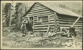
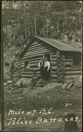
Print preview Close

Showing 20447 results

Archival description
20447 results with digital objects Show results with digital objects
Police Barracks at Mile 47
2009.5.3.49 · Item · 1911
Part of Taylor-Baxter Family Photograph Collection

Photograph depicts three men wearing semi-formal attire at doorway to log building, miscellaneous supplies leaning against base of building. Dirt road in foreground, forest trees on hillside in background. Handwritten annotation on verso of photograph reads: "Mile 47 B.C. Police Barracks.", on recto of photograph: "Summit of Yellowhead pass and east boundary of British Columbia Mile 0. 699 miles to Prince Rupert. Tete Jaune Mile 52. Mile 47 east of Tete Jaune in the Park.", "1911".

Police Barracks at Mile 29
2009.5.3.48 · Item · 1911
Part of Taylor-Baxter Family Photograph Collection

Photograph depicts three men in semi-formal attire standing on front steps of log building with tin roof. Shovels, saw, ladder, buckets, boxes and logs lean against building. Forest trees, buildings, and hillside can be seen in background. Handwritten annotation on verso of photograph reads: "Police Barracks. Mile 29 B.C.", on recto of photograph: "Mile 29 East of Tete Jaune Mile 52."

2013.6.36.1.145.05 · Item · Aug. 1997
Part of David Davies Railway Collection

Photograph depicts a pole yard of Gorman Bros Ltd. Loading methods and quality were checked by CN inspectors in Kamloops, then on the main trans-continental line. These particular lines were destined for Ontario.

2013.6.36.1.149.11 · Item · 10 Aug. 1991
Part of David Davies Railway Collection

Photograph depicts where the Coquihalla Highway crossed over Coldwater River, 3 miles northwest of Brookmere. Trackage in the foreground was constructed in 1984/85 as its original routing interfered with the construction of the new highway built in 1985/86. This rebuilt rail bed had only been in use from 184/5 to May 1989.

2006.20.12.23 · Item · [ca. 1940]
Part of Northern BC Archives Historical Photograph Collection

Handwritten photo album caption below this photo reads: “Fort St John Apron. F/Rideouts 'Norseman'^" Arrow is pointed at plane on far right with the number "2466" on its side and unidentified equipment below. Runway in foreground, approximately four military planes in background surrounded with unidentified people and equipment.

Royal Canadian Air Force
Plane on Summit Lake, BC
2005.3.37 · Item · [ca. 1945]
Part of John Hart Highway Photograph Collection

Handwritten caption above this photo reads: "Plane on Sumit Lake." Logs can be seen floating on water in foreground, as well as trees on opposite shore in background. The seaplane has the letters "CF-ATF" on its side.

Plane on Summit Lake, BC
2005.3.36 · Item · [ca. 1945]
Part of John Hart Highway Photograph Collection

Handwritten caption above this photo reads: "Plane on Sumit Lake." Logs can be seen floating on water in foreground, as well as trees on opposite shore in background. The seaplane has the letters "CF-ATF" on its side.

Placer mining in Hixon, BC
2007.17.1.5 · Item · [ca. 1933]
Part of James Joseph Claxton Photograph Collection

Photo is adhered to paper backing, upon which handwritten annotation on recto reads: “Placer mining Hixon B.C. Hungry 30ies. This picture taken on top of hill across from Quesnel Quartz Mine maybe 800 ft west of Quartz taken approx 45 yrs ago (1933) 1978.12.19”

Placer Mining Hixon, B.C.
2007.17.1.1 · Item · 1933
Part of James Joseph Claxton Photograph Collection

Two men stand below a large upright hose that is spraying a powerful stream of water against the side of a rocky hillside. Annotation on verso of photograph states: "Placer Mining Hixon (Hungry Thirties) This picture taken on top off Hill Across from Ques. Qarts. Maybe 800 Ft. west of Quarty There pictures taken approx 45 years ago Your friend(?) Box 156 Squamish B.C. Dec. 19/78"

2009.7.1.150 · Item · [ca. 1878 - ca. 1915]
Part of Archdeacon W. H. Collison fonds

Photograph features a steep cliff across water, rocky shore in foreground.

Handwritten annotation on verso reads: "Up the 'Big Creek' at Kincolith B.C. Rock face called 'the place of echoes' by the Indian people."