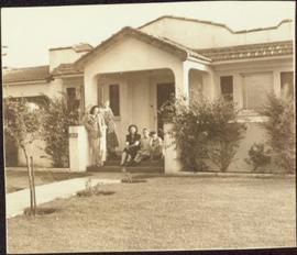
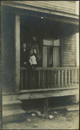
Photograph depicts a woman, man and young girl believed to be A. K. Bourchier's niece Jean, standing on front balcony of house.
Three woman, young girl, and young boy stand and sit in entry way of house with tiled roof. Sidewalk, front lawn, and hedges in foreground. Photograph believed to have been taken in Los Angeles, California.
Photograph depicts the north bank of False Creek in Vancouver, B.C. The photograph was taken from the Cambie Bridge, with a view looking west.
Photograph depicts a totem pole supported by smaller poles, and a second totem pole standing straight in background. Beach in foreground, fence and hills in distance.
Handwritten annotation on verso reads: "Falling greatness, Chapt. XXI No. 5, A Chief's Totem Pole inclined to fall. [Gitaix?] Encampment, Nass River. Five illustration for Chapt. XXI."
Image depicts some fallen trees at Island Cache.
Typed annotation on recto: "The Factor's Home H.B.Co. Post Fort St. James, Stuart Lake, B.C." Man and woman stand formally attired in front of small, square, white house. Log fence and tree-covered hillside in background.
Façade of the Arch-cathedral in St. John's in Warsaw, Poland.
Photograph taken during European Sports Tour with Team Canada.
Photograph depicts the pre-renovation exterior of the Kitkatla school with playing children.
Photograph depicts the pre-renovation exterior of the Kitkatla school.
Image depicts a view of an experimental farm, possibly taken from Tabor Mountain.
Image depicts the Exhibition Sports Centre, which used to be a drill hall army base, on Keller Street in Prince George, B.C.
Image depicts the Europe Hotel in Prince George prior to its demolition in the 1980s; however, the slide itself was only made in 1999 and the date of the photo is otherwise unknown, but most likely around 1979.
Polaroid photograph depicting large sanatorium building. Vehicles parked on street in foreground. Handwritten annotation on verso of photograph: "The Sanatorium. Fort Qu'Appelle - July 6/79".
Photograph depicts a steeple on the side of a church. Annotation on recto of photograph states: "English Church, Port Essington, B.C."
Image depicts the Endako Hotel in Endako, B.C.
Image depicts the Endako General Store in Endako, B.C.
Image depicts a train passing through Endako, B.C.
Photograph depicts a view looking east from the end of the C.P.R. track at Coal Harbour in Vancouver, B.C.
Image depicts a building surrounded by a tall, circular enclosure somewhere on Haida Gwaii, B.C.
Photograph depicts an empty site at 1000 Beach Ave. in Vancouver, B.C.
Image depicts employee houses on mill site in Giscome, B.C. Tug boats are in the foreground on the right. Map coordinates 54°04'23.4"N 122°22'16.9"W
Elevated view of Third Avenue in Prince Rupert. Signs for "Chris Mill Bakery" and "Overwaitea" are visible on the left side of photograph. Printed annotation on recto reads: "3rd Ave Prince Rupert BC."
Elevated photograph of Prince Rupert taken from a hill. Residential and business buildings are visible. Background shows water and wooded hills. Printed annotation on recto reads: "Prince Rupert BC 22."
Elevated photograph of Prince Rupert taken from a hill. Printed annotation on recto reads: "Prince Rupert BC McRae Bros." Handwritten annotation on verso reads: "11/June c/o PG Prince Rupert, B.C. Dear Rae[??], How about a letter. Love for all, Frank." Postcard is addressed to: "Miss R Boew. Bernie PG [illegible]." Postmark on verso reads: "Prince Rupert BC Jun 11 1 PM 1915."
Elevated photograph of Prince Rupert taken from a hill. Printed annotation on recto reads: "Prince Rupert BC W.W.W." Handwritten annotation on verso reads: "2402 Cork Street."
Photograph depicts the electricity station at Coghlan on the B.C. Electric Railway, which is 9 rail miles east of Langley in the Fraser Valley. The view is looking east.
Photograph depicts the CPR line at Eholt, located at mile 108.7 from Nelson on the Boundary Subdivision. It was a formerly bustling junction with the left-hand spur leading to Phoenix. Nor it only has 3 way freight trains a week from Nelson to Midway. The view is looking west.
Photograph depicts a large totem pole next to groomed dirt paths. Power poles and river visible in background.
Handwritten annotation on verso reads: "Edenshaw pole in park at Prince Rupert."
Photograph depicts town buildings on opposite shore. Beach and dock can be seen in foreground.
Handwritten annotation on verso reads: "Chapter XXII, No 1. Eastern Section of Port Simpson as christianized."
Photograph depicts East Pender St., looking west towards the Vancouver Sun newspaper office near Abbot St. in Vancouver, B.C.
Row of buildings with path and poles. Rough cleared land in foreground, men visible in far left background.
Photo of the Prince Rupert harbour. Many buildings are visible along the shoreline. Annotation on recto reads: "Harbour, Prince Rupert BC. 1658." Handwritten annotation on verso reads: "Early Prince Rupert. Good view of Metlakatla Passage in distance- showery[?] Wolf Island."
Photo of the Prince Rupert harbour. Many buildings are visible along the shoreline. Annotation on recto reads: "Harbour, Prince Rupert, BC. 1658."
Photograph depicts wood houses behind stand of trees in Cassiar valley. Truck, power poles, and road in foreground, mountains in background. Typed caption below photo in original duotang album: "Two Bedroom Pan-Abode Houses - Cassiar Townsite". Handwritten annotation on verso: "Sept 1954".
Photograph depicts the North peak of McDame mountain in the earlier stages of strip mining, South peak unmined in background. Quonset and other shops visible in left foreground, unknown building built into mountainside in right foreground.
Early spring landscape with roadbed and track in foreground, river in midground, and hill in background.
Handwritten annotation on recto: “PRINCE GEORGE 4-20-13”.
Photograph of several commercial and residential buildings, including the church and "The Big Furniture Store." Annotation on recto reads: "Prince Rupert. BC Allen Photo July '11." Handwritten annotation on verso reads: "Early day- Prince Rupert."
Totem pole stands alone against a mountainous background.
Overview of sawmill situated in valley. Finished lumber visible in distance.
Image depicts a duplex in Wells, B.C.
Image depicts the train tracks at the old Dunster Station in Dunster, B.C.
Image depicts the interior of the old Dunster Station in Dunster, B.C.