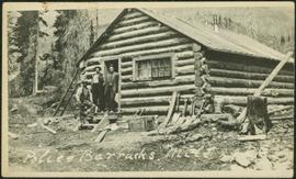
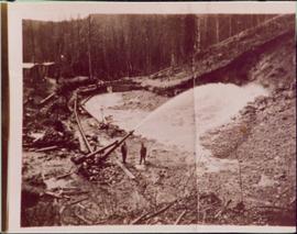
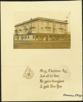
Photograph features the hotel on George Street, Prince George BC. Handwritten annotation on verso of photograph reads: "Xmas [1948?]", on recto: "From Mr. & Mrs. Fask Douglas." Poem on verso reads: "May Christmas Joy And all its cheer Be yours throughout A good New Year".
Image depicts the Prince George Hotel.
Image depicts a Prince George residential area from the viewpoint of the Ginter Property.
Item is a photograph of Prince George taken from the air, looking east with the Cameron Street Bridge in the foreground.
Image depicts Prince George from the view of Peden Hill.
Image depicts the Courthouse in Prince George, B.C.
Image depicts Brunswick Street at 3rd Ave in -35 degree weather. Map coordinates 53°55'03.0"N 122°44'51.7"W
Image depicts 3rd Ave at Brunswick Street in -35 degree weather. Map coordinates 53°55'03.0"N 122°44'51.7"W
Image depicts an uncertain street in Prince George, B.C.
Image depicts Prince George, with the picture looking North-Northeast from University Way.
Image depicts Prince George from University Way, with the P.G.I pulp mill in the distance.
Image depicts Prince George from University Way, with the P.G.I. Pulp Mill in the distance.
Image depicts a view of Prince George from City Hall looking northeast along George Street. Map coordinates 53°54'46.3"N 122°44'41.9"W
Image depicts downtown Prince George looking northwest. Map coordinates 53°54'48.7"N 122°44'45.6"W
Image depicts a view of Prince George from City Hall looking northeast along George Street. Map coordinates 53°54'46.3"N 122°44'41.9"W
Image depicts Prince George, possibly with the Northwood Pulpmill in the background.
Image depicts a view of Prince George from an uncertain location.
Image depicts a view of Prince George.
Image depicts Prince George, B.C.
Image depicts an aerial view of what is possibly an outlying area of Prince George, B.C.
Image depicts downtown Prince George looking northwest across Dominion Street. Map coordinates 53°54'48.7"N 122°44'45.6"W
Image depicts Prince George, possibly with the Northwood Pulpmill in the background.
Image depicts Prince George with numerous trees obscuring most of the view.
Image depicts Prince George.
Image depicts the interior of a mall in Prince Rupert, B.C. It is possibly the Pride O' the North shopping mall.
Image depicts the interior of the Pride O' the North shopping mall in Prince Rupert, B.C.
Image depicts the Pride O' the North shopping mall in Prince Rupert, B.C.
Previous site of sawmill in Giscome, B.C. looking northwest. Map coordinates 54°04'19.7"N 122°22'04.7"W
Image depicts a powerhouse in Prince George, B.C.
Handwritten annotation on recto of photograph: "POURING RIBS JUNE 29/64." Photograph depicts construction workers on large wooden framework structure extending from base of crusher building. Ladders stand parallel to structure against mountainside. The boom of a crane is visible in foreground. Miscellaneous construction equipment and materials throughout.
Photograph depicts the post office, store, and gas pump in Clayburn, north of Abbotsford, B.C.
Street view of Third Avenue in Prince Rupert. Printed annotation on recto reads: "60 Post office 3rd Ave Prince Rupert BC."
Photograph depicts a post office on Main St. in Cumberland on Vancouver Island. It was built in 1907 in a similar style to the building in Ladysmith.
Photograph of post office and neighbouring building. Both buildings are composed of wood and tent materials. Annotation on recto reads: "Post Office & Customs House, Prince Rupert, BC."
Image depicts the post office in Wells, B.C.
Photograph depicts large square model of the new mill building that was built at the Cassiar plant site in 1970. Model is displayed on platform draped with green material. Machinery modeled inside the structure is colour-coded.
Photograph depicts seven men posed in formal attire on front steps to large official building.
Possibly the ‘Iona Campagnolo’ rhododendron.
Photograph depicts Port Simpson in winter. Water and shoreline in foreground, hill in distance.
Handwritten photo caption below image reads: "Port Simpson".
Image depicts a pulp mill in Port Edward, B.C.
Image depicts an old pool hall somewhere in Wells, B.C.
Image depicts an old pool hall, crowded with unknown individuals, somewhere in Wells, B.C.
Photograph depicts three men wearing semi-formal attire at doorway to log building, miscellaneous supplies leaning against base of building. Dirt road in foreground, forest trees on hillside in background. Handwritten annotation on verso of photograph reads: "Mile 47 B.C. Police Barracks.", on recto of photograph: "Summit of Yellowhead pass and east boundary of British Columbia Mile 0. 699 miles to Prince Rupert. Tete Jaune Mile 52. Mile 47 east of Tete Jaune in the Park.", "1911".
Photograph depicts three men in semi-formal attire standing on front steps of log building with tin roof. Shovels, saw, ladder, buckets, boxes and logs lean against building. Forest trees, buildings, and hillside can be seen in background. Handwritten annotation on verso of photograph reads: "Police Barracks. Mile 29 B.C.", on recto of photograph: "Mile 29 East of Tete Jaune Mile 52."
Photo is adhered to paper backing, upon which handwritten annotation on recto reads: “Placer mining Hixon B.C. Hungry 30ies. This picture taken on top of hill across from Quesnel Quartz Mine maybe 800 ft west of Quartz taken approx 45 yrs ago (1933) 1978.12.19”