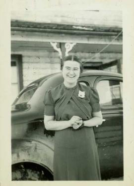
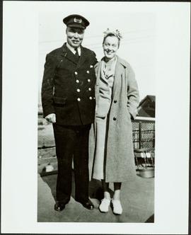
Photograph depicts an unidentified woman standing with a man in uniform, believed to be an officer aboard the S.S. Tutshi. Stamped annotation on verso: "Yukon Archives, Whitehorse. Print No. 82/378 #1; Please credit: Poirer Collection, Yukon Archives."
Photograph depicts group of 12 men standing on steps at back of main office. Front row: Jack Berry, Mickey Dopson, Andre Beguin, Fred Murray. 2nd row: Dick Stevens, Rene Pasiaud. Third row: Craigie Hood, Alex Powell. Back row: Dr. Charles Cobb MD, Peter Davies, Chuck Caron (holding paper), Bill Johnston. Berry and Dopson are wearing hard hats. Windows and doors of office building in background. Stamped annotation on recto of photograph: "Munshaw Colour Service Ltd. OCT 24 1958".
Photograph depicts the office of the Central Coal Co. Ltd., located on the south outskirts of Nanaimo, B.C. beside the Esquimalt and Nanaimo Railway. The building is one of the last pieces of evidence of coal distribution in Nanaimo.
Image depicts an oddly shaped tree branch that appears to have grown downwards, and is covered in green, mossy growths. Located somewhere on Haida Gwaii.
Photograph depicts a vessel called the "Ocean traveller." It was backing off from a public pier in Ucluelet.
Photograph depicts the "Ocean Gem" fishing boat at the Prince Rupert marina. The Prince Rupert Fisherman's Co-operative Assocation Building is visible in the background.
Postcard image of Ocean Falls with mountain in background
Caption: Log shoot in the foreground; the streets are made of wood; paper machine rooms on the left.
Caption: Salt Chuck (Sea) in the foreground. The plant on the right with the booms of the logs ready for the sawmill. The town-site on the left, Link Lake in the background.
Caption: Ocean Falls after a snow shower. Taken from Don and Bessie's home.
Photograph depicts four men standing under balcony of hotel near other buildings on street. Trees line the street, with protective structures built around their trunks. It is speculated that one of these men may be Mr. A. K. Bourchier. Handwritten annotation on recto of photograph: "As you were".
Image depicts a group of unidentified individuals look through an observatory window at an uncertain location, possibly in Fort St. John, B.C.
Image depicts the Oblates of Mary Immaculate Catholic Church in Aleza Lake, B.C. Map coordinates 54°07'08.2"N 122°02'00.0"W
Typed caption glued to album page directly below photograph reads: "14. Oats at Fort Fraser." Photograph depicts a field of oats edged by a wooden fence. Photographer: Dominion Stock & Bond Corporation.
Sally Tretiak standing outside with hands clasped. An automobile and a building visible in the background. Handwritten annotation on verso reads: "1932, Sally Tretiak, Indian nurse, Kispiox".
Photograph depicts numerous buildings along a shoreline with water in the foreground.
Photograph depicts forklift operator Novica Dancetovic in shipping.
Photograph depicts a notice posted in Stanley Park at the head of Coal Harbour, Vancouver, B.C. Notice is for summer visitors only.
Photograph depicts the notice on the outer door of the Great Northern Railway depot in Vancouver.
Photograph depicts a notice found on old North Vancouver Ferry #3, moored as a tender at Western Fish Boat Works, Queensborough, Lulu Island. It was signed by the Corporation of North Vancouver.
Image depicts the office at the Northwood Upper Fraser Saw Mill and a sign which reads "Have a safe, quality day." Map coordinates 54.117916, -121.943351
Image depicts the Northwood pulpmill in Prince George B.C.
Image depicts the Northwood Pulpmill in Prince George, B.C. taken from above the Nechako River looking east. Map coordinates 53°56'00.0"N 122°44'29.7"W
Image depicts the Northwood pulpmill in Prince George B.C.
Photograph depicts Northwood Pulp and Timber Ltd, Prince George. Located north of the city, near the BC Rail and CNR mainline tracks. It had its own railway of about 5 miles in length and two diesel switchers.
Overview of washer line.
View of new control room post mill expansion. Seated with back turned is Nells Kristenson (group operator).
The new digester building under construction.
P.G.E. railcar filled with chips being dumped via hydraulic chip dump.
Brown stock decker.
Aerial perspective - Pulp mill complex, pre-expansion - dramatic night shot.
Image depicts the Northwood Bridge crossing in Prince George B.C.
Image depicts the Northwood Bridge in Prince George, B.C.
Image depicts what appears to be a saw mill belonging to Northwood. The location is uncertain.
Photograph depicts a Northwestern Pacific speeder.
Photograph depicts the view to the northwest from the site of the terminal building at the Rainbow Lake Ski Club.
Photograph depicts a small coastal village in northern British Columbia.
Photograph depicts a northward view of the east side of the CN yards at the Kamloops Junction.
Photograph depicts a Northland steam tug at Vancouver. The tug, "Commodore Straits," one of the largest on the coast of B.C.
Image depicts an old building with a sign labelled "Northern Rooms" in an uncertain location somewhere in Prince George, B.C.