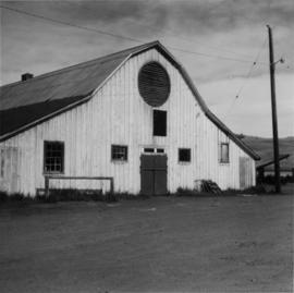
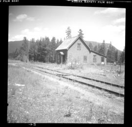
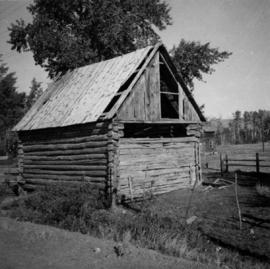
Photograph depicts a cattle shelter/ barn at the head of Nicola Lake, 20 miles east of Merritt, near the Douglas Lake road turnoff.
Photograph depicts a cattle shed located 3 miles east of Pavilion Lake, which is 15 miles northeast of Lillooet. It may have been a settler's cabin at one time.
Photograph depicts a cattle barn of the Douglas Lake Ranch.
Photograph depicts Catholic church, with rectory on its left, and First United Church behind. A wood boardwalk crosses midground, and a man can be seen riding a bicycle near church. Power lines and rough cleared land in foreground, hills and mountains in background. Handwritten annotation on recto of photograph: "Church in Rupert."
Image depicts the Catholic Church in Penny, B.C.
Photograph depicts the catholic church at Cobble Hill on Shawnigan Lake.
Image depicts a Catholic Church in Stewart, B.C.
Image depicts a Catholic church at an unknown location.
Photograph depicts the Cassiar townsite behind shadow in foreground. Plantsite can be seen including the mill, dry rock storage building, tailings pile, and many other buildings. Mountains in background. Handwritten annotation on recto: "<- 13 1/2" ->". (This photograph was made into a promotional poster.)
Photograph of Cassiar Towniste with pen annotation on front "Deyo August 1979 - 2 October 1992)."
Image depicts several unidentified individuals inside a building, one of which is carving a totem pole. The location is uncertain.
Carvings sit among bushes in front of what appears to be a totem pole.
Handwritten annotation on verso reads: "Eagle & whale Monument Tanu".
Image depicts the Carter Industrial Area in Prince George, B.C.
Street view photograph looking down Carson Avenue at the Front St. intersection in Quesnel, BC. Several identified businesses line the gravel avenue on the right; however Cowan's Hardware store is visible at the intersection on the left. Printed annotation on recto reads: "Carson Ave., Quesnel, B.C. 1930 Looking East."
Elevated view of Third Avenue in Prince Rupert. Several cars and delivery trucks are visible driving along the road. Printed annotation on recto reads: "3rd Ave Prince Rupert BC Photo by Wrathalls."
Photo depicts a street perspective cars lining Third Avenue, in Prince George, BC, ca. 1950. Annotation recto reads: "3rd Ave Prince George BC Photo J. Wrathall." Handwritten annotation in pen on verso of postcard reads: “This is the equivalent of our Granville Street. Both theatres are located here as well as Hudson Bay Co., banks, library & stores.”
Image depicts a red carriage labelled in yellow "B.C. Express Co. No. 20." It is possibly located in Kamloops, B.C.
Photograph depicts the Carmi Depot located at mile 46.6 on the CPR line in the Carmi Subdivision. This is the only surviving building at the depot. The layout here consisted of 4 passing/storage tracks and 1 short siding. The view is looking north and upgrade.
Photograph depicts two, four-horse stagecoaches laden with passengers parked outside the Hotel Northern in South Fort George. A group comprised of primarily men watch the stagecoaches from the veranda of the hotel. Handwritten annotation in bottom right corner of photograph reads: "Cariboo Stage at South Ft. George, BC. Oct 19-1911."
Photograph depicts large crowd gathered in front of three story building.
Printed annotation on recto of photograph: "CARIBOO STAGE AT SOUTH FT. GEORGE B.C. OCT 19 -1911".
Image depicts the abandoned Cariboo Rooms, and a liquor store in Wells, B.C.
Image depicts an old, boarded up building labelled as "Cariboo Rooms" in Wells, B.C.
Image depicts the Cariboo Road passing through the Cottonwood House Historic Site.
Image depicts a Cariboo Ranch style house at College Heights in Prince George, B.C.
Image depicts the Cariboo Lake, with the roof of an old log cabin visible.
Image depicts a log house at an uncertain location; the slide is simply labelled "Cariboo."
Photograph taken at terrace gardens, Government House in Victoria, B.C.
Image depicts the train station in Carcross, Y.T.
Handwritten photo album caption below this photo reads: “The Next Morning.” Photograph depicts man believed to be Captain Read, arms linked with a second unidentified man in uniform. The two men are standing on wood slat sidewalk in front of building with many windows speculated to be barracks [see item 2006.20.12.16] at Fort St. John. This photograph was beside item 2006.20.12.19 which depicts unidentified man in this photo and a second man, ready to go out for the evening.
Royal Canadian Air ForceHandwritten photo album caption below this photo reads: “Cpt. Read.” Photograph depicts the captain sitting in open doorway of Officers’ Quarters [see item 2006.20.12.15] at Fort St. John. Wood slat sidewalk in foreground.
Royal Canadian Air ForcePhotograph depicts a monument and grave stone for Captain Frank Odin of the Steamboat Charlotte. Annotation on verso: "Capt. Odin Monument, Soda Creek cemetery, 2010".
Buildings visible on shore in distance.
Handwritten annotation on verso reads: "Amidst drift ice on Fishing Bay Nass River. Insert at Page 38. Indian Fishing Encampment".
Canoes sit on shore in foreground beside village buildings. A dock is visible above water in background.
Handwritten annotation on verso reads: "Alert Bay Indian Ranch No. 14 Alert Bay. To be shown on page 69 or 70, re Alert Bay Mission."
View of Pier and cluster of houses with trees in the background. Water crosses midground, canoes on beach in foreground. Printed annotation on verso reads: “Port Simpson.", handwritten in pencil: “B.C. 1907”.
Image depicts a church and several other buildings in Canoe Creek.
Image depicts a house located somewhere in or near Canoe Creek.
Image depicts a view of Canoe Creek.
Photograph depicts an empty canoe floating directly in front of small white tents on opposite shore. Forest trees in background.
Photograph depicts a building under construction with wood planks on the dock in the foreground and a forested area in the background.
Image depicts the BC Packers Ltd. cannery in Prince Rupert, B.C.
Image depicts the Canadian National Railway Yards in Prince George, B.C.
Photograph of a factory on the shoreline amidst a forested area. The factory is emitting steam or smoke and has a white exterior. Annotation on recto reads "Canadian Fish & Cold Storage Co. Prince Rupert BC."
Photograph depicts a Canadian Customs House. The border crossing was only open between 8:00 a.m. and 5:00 p.m. daily.
Photograph depicts Canada Trust/ Realtor at 1633 4th Avenue.
The item is a photograph depicting the exterior view of the front of The Health and Welfare Canada Medical Services building at 1294 3rd Avenue, Prince George. There is a grey and red Ford pickup truck parked in front of the building. Part of Household Finance HFC at 1272 3rd Avenue can be seen. Photograph originally taken between 1978 and 1979.
The item is a photograph depicting the exterior view of the front of The Health and Welfare Canada Medical Services building at 1294 3rd Avenue, Prince George. There is a grey and red Ford pickup truck parked in front of the building. Photograph originally taken between 1978 and 1979.
The item is a photograph depicting the exterior view of the front of The Health and Welfare Canada Medical Services building at 1294 3rd Avenue, Prince George. Savers Optical can be seen in the background. Photograph originally taken between 1978 and 1979.
Photograph depicts five long buildings in forest clearing, lining left of a road down the center of the image. Wood piles are stacked against buildings. Men can be seen in distance near a white tent.