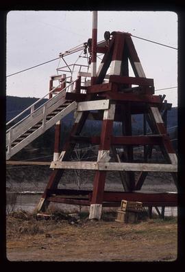
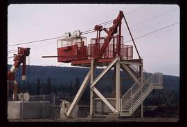
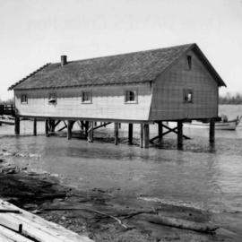
Photograph depicts a fisherman's house, lived in and owned by a First Nations man (?), on the south bank of the south arm of the Fraser River. It is about 5 miles southeast of New Westminster at approximately 9000 block of River Road.
Photograph depicts a wooden flume funneling water in a forested area. Photo is adhered to paper backing, upon which handwritten annotation on recto reads: “First wash for gold by Hixon Creek Cariboo Gold Co. Across Hixon from Quesnel Quartz up the hill. North side of creek 1930’s”
Photograph depicts a wooden flume funneling water in a forested area. Photo is adhered to paper backing. Original annotations on verso of photo are covered by paper mounting. Typed annotation on recto of paper reads: “First wash for gold by Hixon Creek Cariboo Gold Co. Across Hixon from Quesnel Quartz up the hill. North side of creek 1930’s”
Photograph of a mustachioed man perched atop a cart load of lumber hitched to a team of horses. Annotation on recto reads: "First Team Hitched Up at Prince Rupert May 1908."
Photograph depicts a man and woman standing on steps to a round tower in fenced area. Roofs of other buildings can be seen below on right; water and shore visible in background.
Printed on image: "Indian Jail, Metlatkla".
Image depicts several unidentified individuals standing outside a building, and holding intricately painted drums; the woman on the right is Sue Sedgwick. The location is uncertain.
Image depicts several unidentified individuals standing outside a building and holding intricately painted drums; Kent Sedgwick is standing the middle of the group with Sue Sedgwick beside him. The location is uncertain.
Image depicts several unidentified individuals standing outside a building, and holding intricately painted drums. The location is uncertain.
Image depicts several unidentified individuals standing outside a building, and holding intricately painted drums; the woman on the right is Sue Sedgwick. The location is uncertain.
Photograph depicts rows of grave markers in foreground, fence and buildings in background.
Handwritten annotation on verso “Indian cemetery, Reserve #1 South Fort George".
Photograph depicts the First Narrows looking east from the base of Point Atkinson lighthouse.
Photograph of two men in a car driving down a wooden road in Prince Rupert, BC. Printed annotation on recto reads: "First Motor Car in Prince Rupert, B.C., May 1909." Handwritten annotation on verso reads: "Milwaukee Ore. Nov 7 1913. Dear Friends. Just a line. We are comming[sic] over Sunday if it don't rain to[sic] hard. How is Fredie? Hope he is alright. If you had other plans for Sunday you can phone us. Best regards from us both. Mrs Ed Herry[??]." Postcard is addressed to: "Mrs. J Reichard 3404 34 L. St. Vancouver Wash." Verso is affixed with a one cent American stamp. Postmark reads: "Milwaukee [illegible] Oreg."
The item is a photograph of the front exterior of Prince George's first hospital at 1584 8th Avenue, Prince George.
The item is a photograph of the side and back exterior of Prince George's first hospital at 1584 8th Avenue, Prince George.
The item is a photograph of the front exterior of Prince George's first hospital at 1584 8th Avenue, Prince George.
The item is a photograph of the side and back exterior of Prince George's first hospital at 1584 8th Avenue, Prince George.
Image depicts a snow sculpted fire place and couch on a skating rink, possibly during the Winter City Conference, in Prince George, B.C. Taken at the Prince George Civic Center. Map coordinates 53°54'45.6"N 122°44'59.6"W
The item is a photograph depicting the previous fire hall in South Fort George before it was remodeled into a house. Annotations on the reverse side of the photograph state, "S. Ft. Geo fire hall c. 1911 remodeled as house occupied 2009."
The item is a photograph of the front of Fire Hall No. 1, 7th avenue in Prince George.
The item is a photograph of the front of Fire Hall no. 1, 7th avenue, Prince George.
Image depicts the old Fire Hall, now a museum, in Stewart, B.C.
Photograph depicts a west end fire hall in Vancouver on Nelson and Nicola St.
Photograph depicts the fire hall in Moyie, 20 miles south of Cranbrook. When the photo was taken there were 2 hose reel carts inside, a hose, and huge log stove under the hose drying tower (partially seen through window). Moyie was a prosperous village about 1900-1910.
Photograph depicts a former fire hall that was now preserved.
Photograph depicts the fire hall at Lillooet, including an old hand drawn hose reel carrier.
Photograph depicts a fire hall for fire float VFD "J.H. Carlisle" at False Creek. It is on the north shore and in line with Willow St., Vancouver.
The item is a photograph reprint originally taken between 1967 and 1975. The photograph depicts the exterior front of the Prince George Fire Hall. The parking lot side of City Hall can be seen in the background.
The item is a photograph reprint originally taken between 1967 and 1975. The photograph depicts the front exterior of the Prince George Fire Department. The parking lot side of City Hall can be seen in the background with two people walking in front of it.
Image depicts numerous tractors at Finning Tractor and Equipment Co. Ltd. located along Highway 97 in Prince George, B.C.
Image depicts numerous skiers standing near a finish line somewhere on Tabor Mountain in Prince George, B.C.
Two carved poles stand in foreground, a third smaller pole visible by wood structure in background.
Handwritten annotation on verso reads: "For heading of Page 12. Fin Back Whale Crest. [?] Totems, S.E. Alaska".
Street view photograph of 5th Street. Printed annotation on recto reads: "5th St. Stewart, B.C. Hughes #127."
Image depicts the intersection of 5th Ave and Highway 97 looking northeast. Map coordinates 53°55'14.0"N 122°46'54.8"W
Image depicts a structure that appears to be a type of zipline, ferry platform at an unknown location.
Photograph depicts the Fernie CPR station, located at mile 34.7 on the Cranbrook Subdivision, which runs from Crowsnest to Cranbrook. In coal mining days this was a busy place but now it has sidings for 153 cars and nothing else. The view is looking east.
Photograph depicts a fence at Nicola village, 7 miles northeast of Merritt.
Image depicts a fence and power lines near the shore on Haida Gwaii. It is possibly a small community such as Masset.
Image depicts a fence, perhaps somewhere in the Chilcotin region.
Image depicts a fence in the Blackwater River area in the Chilcotin.
Image depicts a fence somewhere in Anahim Lake, B.C.
Image depicts a wooden fence at an uncertain location, perhaps somewhere in the Chilcotin region.
Image depicts a wooden fence at somewhere in Meldrum Creek, B.C.
Image depicts a fence somewhere in Anahim Lake, B.C.
Photograph depicts logs lying in brush in foreground, unidentified structures in background (possibly a tent)?
The item is a photograph of the Prince George Federal Government Building, commonly referred to as the 'old post office.' The photograph depicts the exterior west wall of the building. Building was previously located at 1239 3rd Avenue, Prince George.
The item is a photograph of the Prince George Federal Government Building, commonly referred to as the 'old post office.' It has the Canadian coat of arms and "Prince George" above the main door. Annotation on the back states, "c. 1990." Building was previously located at 1239 3rd Avenue, Prince George.
The item is a photograph of the Prince George Federal Government Building, commonly referred to as the 'old post office.' The photograph depicts the exterior west wall of the building. Building was previously located at 1239 3rd Avenue, Prince George.