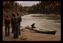
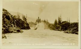
Annotation on recto reads: "SS Inlander in Canyon Skeena River, BC." Handwritten annotation on verso reads: "The Islander going through canyon on the Skeena River."
Photograph taken at Government House, Victoria, B.C.
Image depicts an unidentified individual standing next to a marker and a stake at an uncertain location.
Photograph depicts a stand of evergreen trees.
Image depicts an old, rotting grave marker in the Stanley Cemetery.
Image depicts the Stanley Cemetery.
Image depicts a large vessel docked in Prince Rupert, B.C. The name on its side is "Star Capella." The slide itself is labelled "superport."
Image depicts a long line of people cross country skiing along the Birchleg route on Tabor Mountain in Prince George, B.C.
Image depicts the start of Joffre Creek Road, most likely somewhere in the Joffre Lakes Provincial Park.
Image depicts the start of the Raven trail, with the view angled towards Raven Peak in the distance.
Image depicts a woman standing next to a steam shovel, located in Quesnelle Forks.
Image depicts a steam shovel, located in Quesnelle Forks.
Image depicts a steep mountain road somewhere in the area of Seton Portage, B.C.
Blue sky in background.
Image depicts the Stellako River.
Image depicts an unknown individual with a raft on the Stellako River. The slide is labelled "fisheries research."
Image depicts the Stellako River.
Image depicts a Fisherman wading in the Stellako River.
Image depicts a couple of salmon in the Stellako River.
Image depicts Stewart, with a section of Mt. Shorty Stevenson dominating the background.
Wide angle view of mountains and small residential buildings. A large dock is visible in the foreground. Annotation on recto reads: "Stewart, BC., from Government Wharf."
Image depicts Stewart Harbour in Stewart, B.C.
Image depicts a stone marker in Lamming Mills, B.C.
Image depicts a group of people stopped in the middle of the Fraser River in the Grand Canyon, B.C.
Image depicts what is likely the Dunkley Lumber Mill in Strathnaver, B.C.
Image depicts an aerial view of Strathnaver, B.C.
Image depicts the BCR, as well as the Dunkley Lumber Mill, in Strathnaver, B.C.
Image depicts a view of the Dunkley Lumber Mill in Strathnaver, B.C.
Image depicts a stream somewhere along the White Pass railway.
Image depicts a downhill stream somewhere in the area surrounding Stewart, B.C.
Image depicts a small stream somewhere on Cottonwood Island.
Image depicts a small stream running through a cluster of trees somewhere in or around Seton Portage, B.C.
View of the road descending to the waterfront. Buildings and forested area are visible on either side of street. Annotation on recto reads: "Prince Rupert BC. '07."
Photograph believed to have been taken at Terrace Gardens, Government House, Victoria, B.C.
Photograph depicts the Cassiar mine. North peak featured in left background, South peak in right background, and West peak in right foreground. Area to left of the mining pit and West peak was called the "cirque waste dump." Location of new mine garage can be seen just above the "#7 switchback" road in bottom right foreground.
Photograph depicts the Cassiar mine. North peak featured in left background, South peak in right background, and West peak in right foreground. Area to left of the mining pit and West peak was called the "cirque waste dump." Mountain range visible in distance.
Photograph depicts benches from strip mining operations at the Cassiar mine. Haul trucks and equipment believed to be used for explosive purposes can be seen in mine. Shop and mountain range visible in background. Handwritten annotation on recto of photograph: "Cassiar, BC / June 1970 / by Tom Kiefer". Image consists of three photographic prints adhered together to form one comprehensive panoramic.
Photograph depicts the Cassiar mine after extensive strip mining. It is believed that the North and South peak stand in background, and the West peak in foreground. Handwritten annotation on recto of photograph: "1971".
Image depicts Sue Sedgwick standing next to a camper.
Image depicts Sue Sedgwick standing on the bank of a river.
Image depicts Summit Lake.
Annotation on slide: "Summit Lake Select Trial: Resid. Basal Area Study".