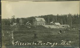
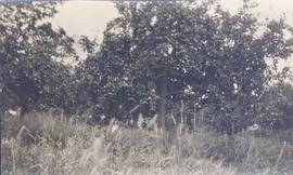
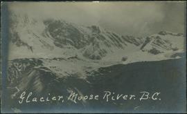
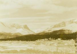
Photograph depicts a grassy plateau leading to forested foothills and rising rocky mountain slopes.
Photograph depicts a landscape shot of a grassy area with fruit-bearing trees in the background.
Photograph depicts Granite Falls near the Wigwam Inn, Indian Arm, Vancouver, B.C.
Photograph depicts Granite Falls and wharf at Indian Arm, looking west from the top of the falls.
Image depicts a large, electric shovel at a mine site somewhere in Granisle, B.C.
Image depicts a drill for blasting holes at a mine site somewhere in Granisle, B.C.
Image depicts numerous bags of blasting powder at a mine site somewhere in Granisle, B.C.
Image depicts an 80 tonne truck at a mine site somewhere in Granisle, B.C.
Handwritten annotation on verso of photograph: "G.T.P. 1st Passenger Train From Prince Rupert. Mile 45. June. 14th 1911. Copyright. F. Button. PHOTO. Pr. Rupert. No. 240." Photograph depicts three men (two sitting on chairs) on caboose of train. Power poles run parallel to tracks, which curve to the right of the image. Train tracks in foreground, forest and mountain in background.
Image depicts the Fraser River and the Grand Trunk Pacific Bridge from Cottonwood Island Park.
River in foreground, trees and cliffs in background.
River in foreground, trees on shore in background. Handwritten annotation on verso of photograph: "Grand Canyon Fraser R."
River in foreground, trees and rocky shore in background.
Photograph depicts an unidentified person seated on rocks in foreground. River crosses midground, cliffs and trees on opposite shore in background. Unidentified structures believed to be buildings can be seen on opposite shore. Handwritten annotation on verso of photograph: "Grand Canyon. fraser R."
Image depicts a grain elevator in Prince Rupert, B.C.
Image depicts a clearing through the woods, possibly an abandoned grade for the BCR. It is possibly located on Iron Road South, near Woodpecker B.C.
Image depicts the Fraser River in the Grand Canyon, B.C.
Image depicts a set of rail road tracks and an old, collapsing log building somewhere in Goat River, B.C.
Image depicts an old, collapsing log building somewhere in Goat River, B.C.
Image depicts the CN Railway and Station at Goat River, B.C.
Image depicts a cabin and several sheds somewhere in Goat River, B.C.
Photograph depicts glacier and snow in mountains. Handwritten annotation on verso of photograph reads: "Glacier, Moose River. B.C."
Image depicts the Gitwinksihlkw Elementary School in Gitwinksihlkw, B.C.
Side perspective of wooden swings covered in snow. Handwritten annotation in pen on verso reads: “The school swings.”
Image depicts the Giscome, B.C. mill site looking west. Map coordinates 54°04'18.5"N 122°21'57.7"W
Image depicts what is possibly the quarry located at Eaglet Lake in Giscome, B.C.
Photograph depicts people and tree stumps in grass areas. Buildings stand on higher level in midground, forest in background. Handwritten annotation on verso of photograph: "Giscombe Portage. B.C.", on recto: "Seaback & Huble"
Image depicts the Giscome mill foreman's house on the hill, with Eaglet Lake in the background and numerous piles of logs in the foreground. Map coordinates 54°04'28.0"N 122°22'05.8"W
Image depicts the Giscome mill foreman's house on the hill. Map coordinates 54°04'28.0"N 122°22'05.8"W
Image depicts an open area with Eaglet Lake in the background. It depicts the previous site of the mill at Giscome, B.C. Map coordinates 54°04'19.7"N 122°22'04.7"W
Image depicts several houses and the Giscome saw mill in Giscome, B.C. in the background. Map coordinates 54°04'20.9"N 122°21'53.1"W
Image depicts Giscome with the school on the left, the remnants of the town site in the middle and the church on the right. Map coordinates 54°03'58.2"N 122°22'04.8"W
Image depicts a farm in Giscome, B.C.
Image depicts a large, old and collapsing barn, as well as a nearby house of the dairy farm in Giscome, B.C. Map coordinates 54°03'53.3"N 122°21'22.6"W
Image depicts the dairy farm in Giscome, B.C. Map coordinates 54°03'53.3"N 122°21'22.6"W
Image depicts the Giscome Community Hall in Giscome, B.C. Map coordinates 54°04'18.5"N 122°21'57.7"W
Image depicts the old CN station in Giscome, B.C. Map coordinates 54°04'20.7"N 122°22'01.1"W
Image depicts the Giscome bunkhouse in Giscome, B.C. Map coordinates 54°04'17.6"N 122°22'06.1"W
Image depicts the Giscome mill site in Giscome, B.C. The railroad tracks are in the foreground. Map coordinates 54°04'17.6"N 122°22'06.1"W
Image depicts the remains of a street of houses in Giscome, B.C. The quarry is slightly visible in the background. Map coordinates 54°04'20.9"N 122°21'53.1"W
Image depicts mill site and dock in Giscome, B.C. with Eaglet Lake in the background covered in ice. There is a large crowd of people gathered near the dock. Map coordinates 54°04'34.9"N 122°21'50.0"W
Image depicts the Giscome, B.C. town site with the Giscome railway station and the Giscome store in the center surrounded by vehicles. Map coordinates 54°04'18.5"N 122°21'57.7"W
Image depicts a road near the Ginter House in Prince George, B.C.
Image depicts a private driveway, most likely leading to the Ginter Property in Prince George, B.C.
Image depicts the Ginter House and the surrounding woods, in Prince George, B.C.