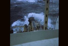
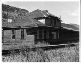
Photograph depicts a weather ship sailing into a wave in stormy weather.
Photograph depicts a weather ship sailing over rough waves.
Photograph depicts the stern of a weather ship with a large body of water in the background.
Photograph depicts an abandoned and worn out grain elevator, with three buildings in a row and the elevators going down towards the ground.
Photograph depicts an abandoned and worn out grain elevator from the side.
Photograph depicts an abandoned and worn out grain elevator, with three buildings in a row and the elevators going down towards the ground.
Photograph depicts an abandoned and worn out wooden building in a flat field.
Photograph depicts an abandoned bridge on the former Coquihalla to Brookmere rail line. This view is about 10 miles northeast of Hope.
Photograph depicts Abandoned building.
Photograph depicting an abandoned building in Soda Creek, the building surrounded by overgrown grass and trees.
Image depicts an abandoned cabin in Quesnelle Forks, B.C.
Photograph depicts an abandoned cabin about 100 yards from the Fraser River on Bridge River road, about 2 miles out of Lillooet.
Image depicts an old, abandoned cabin with ivy growing up the side. The location is uncertain.
Image depicts an old and abandoned cabin with ivy growing up the side. The location is uncertain.
Image depicts several abandoned and collapsing cabins in Quesnelle Forks, B.C.
Image depicts part of a path leading to some abandoned cabins in Quesnelle Forks, B.C.
Photograph depicts abandoned Canadian Railroad Station Fernie BC
Prince George Railway & Forestry Museum SocietyPhotograph depicts abandoned Canadian Railroad Station Natal BC
Prince George Railway & Forestry Museum SocietyImage depicts an old and abandoned, collapsing church at an uncertain location.
Image depicts the interior of an old, abandoned church at an uncertain location; possibly somewhere between Lillooet and Kamloops.
Photograph depicts an abandoned church at Extension, B.C., west of Nanaimo.
Photograph depicts an abandoned coal mine in Coal Creek, 5 miles east of Fernie, BCThe entrance to the mine is unusual and is 2/3rds up the mountainside. The mine was closed in 1959. Flat ground in foreground is littered with at least 100 mine tubs of approximately 3'0' gauge.
Photograph depicts an abandoned CPR grade near Christina Lake. Rockwork was built in 1898 which was quite rare.
Photograph depicts what was once part of Nicola branch. It was later truncated to a spur for oil tanks. At the time the photograph was taken, it was abandoned altogether.