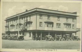
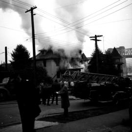
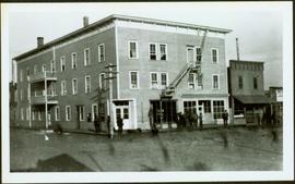
Photograph depicts street corner view of Hotel Fort George with people and utility pole in foreground.
Handwritten annotation on verso “Hotel Fort George Central Fort George 1913".
Photograph depicts street corner view of Hotel Fort George with people and utility pole in foreground.
Handwritten annotation on verso “Hotel Fort George Central Fort George 1913".
Photograph taken at Carmi, an old village between Rock Creek and Kelowna. Visible is an old hotel that was up for sale.
Photograph depicts an old hotel in the center of Keremeos. It once had been a thriving staging post. The village now only contained 2 building which included this hotel and a dance hall that had been converted to a barn.
Street view of many vehicles parked in front of the Hotel Northern. Printed annotation on recto reads: "Hotel Northern, South Fort George."
Photograph of Prince George Hotel with several early model cars and a few people. Printed annotation on recto reads: “Hotel Prince George, Prince George, B. C.”
Photograph depicts three small children (Henry, Charlie and Mary) standing at Sand Creek settlement. A dog stands beside them pulling a small wagon of firewood. Tent and wood buildings in background, including a cafe on far right. Hillside can be seen in distance. Handwritten annotation on recto of photograph reads: "Houghtaling Sand Creek Bourchier 1912".
Photograph depicts Mrs. Houghtaling standing with four small children near doorway of tent building (Gertrude, Mary, Henry, and Charlie). This photograph is believed to have been taken at Sand Creek, BC. Forest trees in background. Handwritten annotation on recto of photograph reads: "Tete Jaune 1912".
Image depicts a house in 127 Mile House, B.C.
Image depicts a house with the main floor and entrance high off the ground. The location is uncertain, likely Giscome, B.C.
Image depicts a house, most likely on Thompson Drive in Prince George, B.C.
Photograph depicts car and shed behind white home with open garage, balcony and porch. Trees and power lines in background.
Photograph depicts the ongoing wrecking of house #1053 on Beach Ave.
Photograph depicts house at #1053 Beach Ave. in Vancouver, B.C. Dan Davies was a resident at one time.
Image depicts a house with a vehicle in a garage and the number 40 on it; location is uncertain.
Photograph depicts a small paddle wheel boat pulled up on the shore, a cluster of small buildings built near the water's edge. Handwritten annotation below photograph reads, "Domicile De Charley- Echo Cove".
Photograph of two horse driven carts driving past a house situated at the foot of a forested mountain.
Photograph depicts large house in cleared area featuring a covered front porch. This is speculated to be the home in which A.K. Bourchier once lived. A second building is semi-visible in background.
Photograph depicts a house fire possibly on 1000 Beach Block and Thurlow St. , caused by a wrecking gang.
Photograph depicts a house fire in West End of Vancouver.
Photograph depicts a house fire possibly on 1000 Beach Block and Thurlow St. , caused by a wrecking gang.
Photograph depicts a house fire on 1000 Beach Block and Thurlow St. on December 18, 1964. A wrecking gang accidently set fire to the house and it took one hour to get the fire under control.
Image depicts a blue house for sale on Upper Fraser Rd. Location is likely Upper Fraser, B.C.
Photograph depicts an Independent Order of Foresters 1895 house.
Photograph depicts a house on Ladner Trunk Rd. in Delta, B.C. It is in the northeast corner of an intersection with the road leading to the Canadian Army Signal Station.
Unidentified house with veranda stands in field, hills in background.
The item is a photograph slide reproduction depicting a blue house surrounded by flood waters in Prince George.
Image depicts a house in Giscome, B.C. Map coordinates 54°04'17.6"N 122°22'06.1"W
Photograph depicts the Moha "ghost" vilage, 20 miles west of Lillooet, at the fork of Bridge and Yalako Rivers. It used to be a gold mining village. About 8 houses/cabins were left standing, but none were occupied. Displayed is one that had 2 ft. thick walss to waist height, as shown.
Photograph depicts the house opposite an 1876 church in Nicola village, 7 miles northeast of Merritt. It may be the manse.
Image depicts a small house with brightly coloured door and window frames in Penny, B.C.
The item is a photograph of three houses in the industrial area off of Queensway in Prince George.
The item is a photograph of a house in the industrial area off of Queensway in Prince George.
The item is a photograph of a house in the industrial area off of Queensway in Prince George. Annotation on back of photograph sates, "2 doors east."
The item is a photograph depicting the back of a four-level stucco house in South Fort George. Various appliances are being kept by the house. The house is likely located in the Hazelton Street area, Prince George.
Photograph depicts house with arched windows. Neighbouring house partially visible on left.
Image depicts and old house and vehicle in Upper Fraser, B.C. Map coordinates 54°07'05.7"N 121°56'38.9"W
Image depicts the interior of an old house, possibly the Cottonwood House, and most likely in or near Barkerville, B.C.
The item is a photograph depicting an old, weathered house near Penny church. The house is in disrepair with a damaged roof and boarded up windows. Annotation on reverse side of photograph states, "Penny church house?"
The item is a photograph depicting a house on 12th Avenue before demolition to make room for the Parkwood commercial area. Annotation on back of picture states, "demolished July / 91 for Parkwood expansion. 1734(?) 12th ave."
The item is a photograph depicting a house on 12th Avenue before demolition to make room for the Parkwood commercial area. Annotation on back of picture states, "removed July / 91 2 blue spruce + 12th ave."
Photograph depicts a house on 10th Ave., Vancouver.
Photograph depicts a house that had been pushed on its side by a bulldozer.
Photograph depicts a house that at the moment was being pushed up on its side by a bulldozer.
Photograph depicts one of the four houses on the corner of Barclay and Nicola. It was being demolished to make way for high rise apartments.
Photograph depicts a house being gutted, prior to demolition.
Photograph depicts one of four houses that were being gutted and demolished to make way for a concrete high rise apartment block. Built circa 1905.
Photograph depicts a house that had a "sold" notice on it and was partly demolished. Up to the date the photograph was captured, this block on Beach Ave. was the sole remaining one to have only houses on it, as opposed to a mixture of houses and apartment blocks, or blocks only.
Photograph depicts a house on the southern edge of Chinatown.