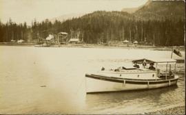
Archdeacon W.H. Collison and an unidentified man on the "Dawn," Collison's boat. Forested hills and several buildings are visible in the background. Handwritten annotation on verso reads: "The 'Dawn' Archdeacon Collison's boat."
Image depicts Wells, B.C.
Image depicts the Helmcken Falls in Wells Gray Provincial Park.
Image depicts the drainage area for the Helmcken Falls in Wells Gray Provincial Park.
Photograph depicts the old hospital building in Wells. At the time the photo was taken, 1978, it was being used as an apartment building, and that is still its current use.
Image depicts woods located west of Leo Creek, with mountains in the distance.
Image depicts a grave somewhere along the White Pass railway.
Image depicts a mountain side somewhere along the White Pass railway. The thin ridge along the mountain side is possibly either a highway or part of the railway.
Image depicts the White Pass Train crossing over a railway bridge at an uncertain location.
Image depicts the White Pass Train crossing over a railway bridge at an uncertain location in the mountains.
Image depicts the White Pass Train crossing over a railway bridge at an uncertain location.
Image depicts an aerial view of Williams Lake, B.C.
Image depicts the St. Joseph's Mission in Williams Lake, B.C.
Image depicts the cableway in Willow River, B.C.
Image depicts the cableway, stretching over a river, in Willow River, B.C.
Image depicts the cableway in Willow River, B.C.
Image depicts a group of people somewhere in Willow River, B.C. The man in the plaid shirt and beige cap is identified on the slide as being Lloyd Edwards.
Image depicts the Willow River General Store. Map coordinates 54°04'23.7"N 122°28'26.9"W
Railroad track, utility poles, field, small building and background hills are visible in image.
Handwritten annotation in pen on verso reads: “Looking out of our classroom window up the street.” According to the donor, the car stuck in the snow belonged to his colleague, Bob White.
Photograph depicts village buildings along shore.
Handwritten annotation on verso reads: "Massett in Winter dress."
Image depicts a river, possibly somewhere in the Wistaria Provincial Park.
Image depicts the old community hall located somewhere in the Wistaria Provincial Park.
Image depicts a woman on a boat, possibly on War Lake.
Image depicts a woman standing on a rocky shore somewhere on Haida Gwaii, B.C.
Woman stands in front of trimmed hedges and palm trees, tall buildings in background. Photograph speculated to depict Sarah Glassey in a warm location such as Los Angeles, California.
Unidentified woman holds pan in area speculated to be a mining location. Steel drums stand behind her, road and grassy hillside in background.
Image depicts an unidentified woman with a camera sitting on the bank of a river.
Image depicts an unknown woman with a camera. Nearby are the skeletal remains of an unknown animal. The location is the upper Fraser Canyon.
Three unidentified women lean over flowing stream in area speculated to be a mining location. Sluiceway appears to be visible in foreground.
Image depicts two snow sculptures near a wooden bridge on an ice rink, possibly during the Winter City Conference, in Prince George, B.C. Taken at the Prince George Civic Center. Map coordinates 53°54'45.6"N 122°44'59.6"W
Winter landscape scene featuring a man cleaning up a wood pile covered with snow (?). Handwritten caption beside this photo reads: "ALL WINTER 1945 1946 Cleaning of the Wood Pile".
Fully loaded logging truck driving along a wood plank logging road. Another road under construction is also visible through forest in background.
Handwritten annotation in pencil on verso reads: “Logging - Giscome B.C. Plank truck road - also road under construction showing sills & cribbing."
Photograph depicts wood planks piled on a dock with wood buildings built along the shoreline of the background.
Photograph depicts a wood planked building on pilings under construction in a forest clearing.
Image depicts the grade for the British Columbia Railway, which was formerly known as the Pacific Great Eastern until 1972. It is located somewhere near the Woodpecker Ranch in Woodpecker, B.C.
Image depicts the grade for the British Columbia Railway, which was formerly known as the Pacific Great Eastern until 1972. It is located somewhere near the Woodpecker Ranch in Woodpecker, B.C. There are two unknown individuals present in the image.
Image depicts a tree line in Woodpecker, B.C.
Image depicts two unknown individuals at the Woolsey Glacier.