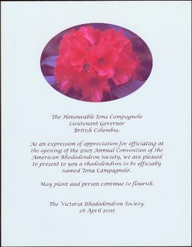
The item is a photograph depicting a plaque titled, "Alexander Mackenzie's Route 1793 'From Canada by Land.'" The map shows Mackenzie's route from Alberta to the Pacific Ocean through British Columbia. Annotation on the reverse side of the photograph states, "installed 1993 Mackenzie bicent."
The item is a photograph depicting the plaque on the Alexander Mackenzie monument in Fort George Park. The plaque is titled "The Explorations of Sir Alexander Mackenzie." The plaque is written in both English and French. Annotation on the reverse side of the photograph states, "installed 1985 Parks Canada bicent."
The item is a photograph depicting a plaque on the reverse side of the Alexander Mackenzie monument titled, "Alexander Mackenzie's Route 1793 'From Canada by Land.'" The map shows Mackenzie's route from Alberta to the Pacific Ocean through British Columbia. Annotation on the slide states "PG new plaque by BC Corp of Land Surveyors."
The item is a photograph depicting the plaque a man reading the Alexander Mackenzie monument plaque in Fort George Park.
The item is a photograph depicting a plaque on the reverse side of the Alexander Mackenzie monument titled, "Alexander Mackenzie's Route 1793 'From Canada by Land.'" The map shows Mackenzie's route from Alberta to the Pacific Ocean through British Columbia. Annotation on the slide states "PG monument."
Photograph of a rhododendron above typed message reading: “The Honourable Iona Campagnolo, Lieutenant Governor, British Columbia. As an expression of appreciation for officiating at the opening of the 2005 Annual Convention of the American Rhododendron Society, we are pleased to present to you a rhododendron to be officially named ‘Iona Campagnolo.’ May plant and person continue to flourish. The Victoria Rhododendron Society. 28 April 2005.”
Handwritten annotation in pen on verso reads: "Dad [W.E. Collison] on ‘Naskeena’ – Prince Rupert Harboue en route to Nass River”.
Indian agency boat the “Naskeena” en route to its next destination. Handwritten annotation in pen on verso reads: “ ‘Naskeena’ en route”
Indian agency boat the “Naskeena” off Kitkatla B.C. W.E. Collison, Indian Agent standing at the stern.
Handwritten annotation in pen on verso reads: “‘Naskeena’ Gov. patrol boat off Kitkatla BC. W.E. Collison on stern.”
Photograph depicts a small cluster of buildings near the river bank.
Caption describing photograph: "T.F.L. #30 - View of McGregor Plateau with McGregor Mountains on horizon, Fraser River with Limestone Creek in foreground."
Caption describing photograph: "T.F.L. #30 - Typical stocking compatible with pre-scarification. C.P. 58."
Caption describing photograph: "T.F.L. #30 - Typical Spruce-Alpine Fir Stand."
Caption describing photograph: "T.F.L. #30 - Species Comparison - Typical first season leader (+/-3") on 2+1 White Spruce adjacent row to No. 1 [2007.1.30.2.126]"
Caption describing photograph: "T.F.L. #30 - Species Comparison - Typical first season leader (+/-12") on 2+1 Lodgepole Pine. Woodall Creek. High Site, outwash sands, after post-scarification."
Caption describing photograph: "T.F.L. #30 - Severely scalped area of 1965 post-scarification, no re-growth of brush, very little regeneration of S-B [Spruce-Balsam or Spruce-Alpine Fir] much of which killed by drought and/or frost heaving." A man kneels in the photograph for scale.
Caption describing photograph: "T.F.L. #30 - As in No. 7 [2007.1.30.2.123], illustrating poor growth of 2+0 planted at same time and on same site as No. 8 [2007.1.30.2.124], brush and grass removed for photo."
Caption describing photograph: "T.F.L. #30 - As in No. 7 [2007.1.30.2.123], illustrating competitive ability of 2+1 Spruce."
Caption describing photograph: "T.F.L. #30 - Re-growth of brush (ferns, grass, horsetail, Rubus). Old T.F.L. #28. Logged 1963, planted Spring 1965." A man stands in the photograph for scale.
Caption describing photograph: "T.F.L. #30 - Condition of 1965 pre-scarification on C.P. 58 (poor coverage), fair to good regeneration B-S [Alpine Fir-Spruce], still receptive."
Caption describing photograph: "T.F.L. #30 - Condition of 1965 post-scarification on C.P. 58. Severe brush invasion." A man stands in the photograph for scale.
Photograph depicts a tethered pack horses in makeshift log stalls between Bella Coola and Anahim Lake during the WWII Polar Bear training exercise.
Photograph depicts a tethered pack horse between Bella Coola and Anahim Lake during the WWII Polar Bear training exercise.
Image depicts a vehicle on a gravel road somewhere near Tête Jaune Cache, B.C.
Image depicts a forest service cabin somewhere near Tête Jaune Cache, B.C.
Image depicts a collapsing shack somewhere near Tête Jaune Cache, B.C.
Item is a photograph of a copy print, resulting in a low quality photographic reproduction. Reproduced as a print, slide, and a negative. Location of original photograph is unknown.
Handwritten photo album caption below this photo reads: "Teslin Lake and River, at 11 000 feet." Photograph depicts winding river below, mountain range in background.
Royal Canadian Air ForceImage depicts the Terzaghi Dam on the Bridge River, looking from the upstream (reservoir) side located near Bralorne, B.C. The water is Carpenter Lake.
Image depicts the Terzaghi Dam viewed from the downstream side near Bralorne B.C.
Photograph depicts Terry Nimmons on Gabriola Island.
Photograph depicts a group of people from the Vancouver-based Terrace Support Group at a picnic table in Kitwanga.
Image depicts a rail road bridge located somewhere near Terrace, B.C.
Image depicts a view of Terrace, B.C.
Photograph depicts the Pacific Terminus of the Trans Canada Highway in Tofino, B.C. on Vancouver Island.
Item is a print of a photograph of tents and newly cleared land in Prince Rupert taken between 1906 and 1908.
Typed caption glued to album page directly below photograph reads: "69. Jordan's Addition on the Banks of the Nechac[k]o River." Photograph depicts three tents situated in an open field near the Nechako River. Photographer: Dominion Stock & Bond Corporation.
Photograph depicts four tents with laundry line hung between them, trees and hills in background. Handwritten annotation on recto of photograph: "The Camp."
Image depicts several orange and blue tents, possibly somewhere near Riske Creek, B.C.
Photo description on accompanying photo album page: " 'Yonge Street' at Teslin Lake, Yukon. The centre tent was used by the radio men. Teslin, 130 miles south of Whitehorse, is the site of one of the aircraft radio stations on the new Edmonton-Whitehorse circuit, paralleling the Alaska Highway."
Photograph depicts tent structures in the early construction camp at Cassiar. Snow-covered area in foreground, trees in background.
Photograph depicts tent structures among trees at the temporary Cassiar construction camp. Taken from future site of garage building, looking northwest, snow-capped mountain in background.
Gathering of tents in Vickersville with the harbour and mountains in the distance. Annotation on recto reads: "Vickersville Prince Rupert o/n[?] 1908."
Photograph depicts a tent camp with lumber and steel drums nearby. A mountain is in the background.
Item is a photograph of a copy print, resulting in a low quality photographic reproduction. Reproduced as a print, slide, and a negative. Location of original photograph is unknown.