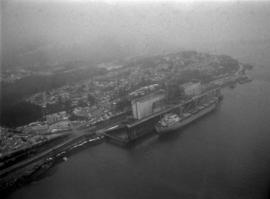
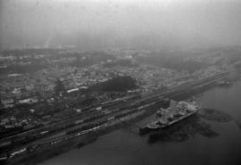
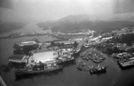
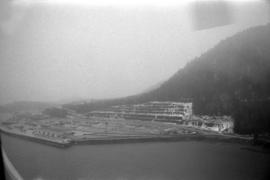
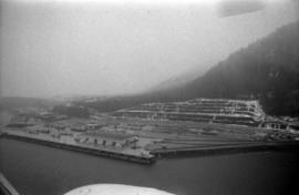
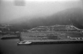
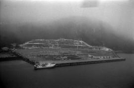
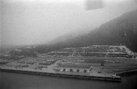
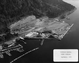
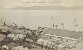
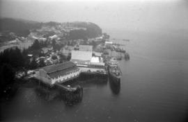
Photograph depicts an aerial view of ships at the Prince Rupert harbour.
Photograph depicts an aerial view of a ship at port in Prince Rupert.
Photograph depicts an aerial view of a ship at port surrounded by logs in Prince Rupert.
Photograph depicts an aerial view of the proposed site for the Fairview general cargo dock elevator site.
Photograph depicts an aerial view of the Prince Rupert harbour.
Photograph depicts an aerial view of the Prince Rupert Fairview Cargo Terminal.
Photograph depicts an aerial view of the Prince Rupert Fairview Cargo Terminal with Prince Rupert in the background.
Photograph depicts an aerial view of the Prince Rupert Fairview Cargo Terminal with a moored boat.
Photograph depicts an aerial view of the Prince Rupert Fairview Cargo Terminal.
Photograph depicts an aerial view of the Fairview container terminal in Prince Rupert
Photograph taken at the Mudbay Light Aircraft Airfield in Delta. Visible is an advanced trainer called the "North American (Aviation Co.) Texan" that was of the USA and Harvard in Britain and Canada. Some were built in Canada during WWII.
Photo description on accompanying photo album page: "The bungalow-like Administration Building under construction at Teslin Lake, Yukon Territory. The top portion will be the control tower."
Photograph depicts the Abbotsford CPR depot. It was built circa 1910-1914 and was the second depot built by the CPR in the town. It is at mile 6.7 on the the Huntingdon branch from Mission City. It was last used for passenger traffic in October 1959. It is No.5 standard design CPR depot.
Photograph depicts the an abandoned steel trestle with the mid span missing about 15 miles northeast of Hope. It was part of the former CPR Coquihalla to Brookmere rail line.
Photograph depicts two abandoned fishboats.
Photograph depicts what was once part of Nicola branch. It was later truncated to a spur for oil tanks. At the time the photograph was taken, it was abandoned altogether.
Photograph depicts an abandoned CPR grade near Christina Lake. Rockwork was built in 1898 which was quite rare.
Photograph depicts an abandoned bridge on the former Coquihalla to Brookmere rail line. This view is about 10 miles northeast of Hope.
Photograph depicts an abandoned and worn out grain elevator, with three buildings in a row and the elevators going down towards the ground.
Photograph depicts the stern of a weather ship with a large body of water in the background.
Photograph depicts a weather ship sailing over rough waves.
Photograph depicts a weather ship sailing into a wave in stormy weather.
Photograph depicts a weather ship sailing in rough weather with waves spilling over the side of the ship.
Photograph depicts a weather ship sailing amidst large water swells.
Photograph depicts a weather ship in the midst of fog.
Photograph depicts a wave breaking over the stern of a weather ship in stormy weather.
Photograph depicts a large wave breaking over the stern of a weather ship.
Photograph depicts a wave breaking over the bow of a weather ship.
Photograph depicts a partially obscured image of a wave breaking over a weather ship.
Photograph depicts a steamboat on the water with forested mountains in the background.
Photograph depicts a ship beached on rocks, leaning heavily to one side with a forested shoreline in the background.
Photograph depicts a sailboat towing two smaller canoes on the water with mountains visible in the background.
Image depicts a road somewhere in Tumbler Ridge, B.C. There are numerous construction vehicles present.
Image depicts a road somewhere in Tumbler Ridge, B.C. There are three bush planes in the image.
Photograph depicts a man standing on a dry-docked boat in front of a wooden building with driftwood in the foreground.
Photograph depicts a man in uniform and a woman posing for a photo on a road situated between a fenced area featuring totem poles. Along the water’s edge in the background there is a float plane, wharf and the Camosun vessel. Handwritten annotation on verso reads: “Alert Bay B.C. Union Steamships Ltd.”; “Alert Bay BC”; photographer’s stamp on verso states: “W.E. Nicholson, 268 E. 10th, Vancouver 10, B.C.”
Image depicts an elevated view of a lake and a road located somewhere near Bralorne, B.C.
Image depicts a house in Island Cache. There are several cars parked outside it.
Image depicts a stretch of highway, possibly Highway 29 or 97.
Image depicts what appears to be a ferry crossing a river at an uncertain location.
Photograph depicts a possible fence post or well digger found near the Prince George Airport.
Image depicts a camper and a man and woman at an uncertain location, possibly somewhere near Meldrum Creek, B.C. The woman in the image is Sue Sedgwick.
Elevated view of various buildings and vessels along the Prince Rupert waterfront. Several piles of lumber can be seen in the foreground. Printed annotation on recto reads: " Prince Rupert B.C., A busy day on the Waterfront."
Image depicts a truck on a bridge, possibly crossing over the Peace River.
Photograph depicts a boat titled Venture on the water with a mountain range in the background.