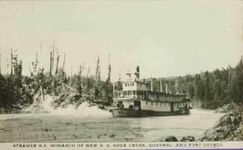
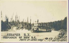
Stern wheeler in river. Printed annotation on recto reads: “Steamer B.X. Monarch of New B.C. Photo by James Heay”
Photograph depicts the steamship Prince Rupert after being run aground on a rocky shoreline. Annotation on recto of photograph states: "STR. PRINCE RUPERT ASHORE NEAR RUPERT MAR 23. 1917."
Postcard depicts a "massive 4-4-0 wood burning locomotive ready to enter the turn table from the round house. These CPR locomotives were in common use from 1886 until 1915, running from the Kootenays through the Fraser Canyon."
Photograph depicts the multi-level steamship "Tutshi" anchored near a rocky shoreline. Stamped annotation on verso: “Yukon Archives, Whitehorse. Print No. No. 82/378 #3; Please credit: Poirer Collection, Yukon Archives”
Image depicts a steep mountain road somewhere in the area of Seton Portage, B.C.
Photograph depicts the stern view of the C.N.R. S.S. Canora, tied to the tidal loading platform at Tilbury Dock, Fraser River, Delta.
Photograph depicts the stern wheel details of the replica of the S.S. Moyie, taken at Coal Habour, Vancouver, two days after launching.
View of a sternwheeler in the distance making its way down Fort George Canyon. Printed annotation on recto reads: "Fort George Canyon."
Photograph features paddle of sternwheeler with the word "CONVEYOR" visible above paddle. Snow on ground, forest on hill in background.
Handwritten annotation on verso in pencil reads: “Tete Jaune B.C.”
Rocks and trees on either shore.
Printed annotation on recto reads: “Steamer B.X. Monarch of New B.C. Soda Creek, Quesnel and Fort George”
Handwritten annotation in pencil on verso reads: “Prince George to Tete Jaune” Hand written message in ink on verso is addressed to “Mademoiselle Elisabeth Joliet, Terrguy – Les Dijore Cote a Or France”.
Rocks and trees on either shore.
Printed annotation on recto reads: “Steamer B.X. Monarch of New B.C. Photo by James Heay”.
Close view of sternwheeler resting on brick supports. Building supplies and sawhorse in foreground. A man can be seen on lower deck, and another above on third deck. Handwritten annotation on recto of photograph reads: "Operator".
Postcard photograph depicts lofty view of sternwheeler in river. Scattered buildings and tents in background, river and shore in foreground. Printed annotation on recto reads: “South Fort George Oct 30th 1910”
Unidentified man can be seen standing by small boat on shore in foreground, a second boat visible in water behind. Hills on opposite shore can be seen in background.
Handwritten annotation on verso reads: "Metlakathla B.C. 'Stern-wheeler' passing village."
3 Sternwheelers tied to a river bank. Printed annotation on recto reads: “Stern Wheelers 1910 Quesnel B.C.” Handwritten annotation on verso in pencil reads: “BX, B.C. Express, Charlotte”
Image depicts a man, possibly Kent Sedgwick, leaning against a sign forbidding public traffic on the Stewart Access Road from between 5 am to 8 pm. Located in Hazelton, B.C.
Image depicts an unknown individual leaning against a sign at the Stewart Access Road which warns travellers to pack several days of food. Located in Hazelton, B.C.
Wide angle view of mountains and small residential buildings. A large dock is visible in the foreground. Annotation on recto reads: "Stewart, BC., from Government Wharf."
Image depicts Stewart Harbour in Stewart, B.C.
Postcard depicts Stoney Creek Bridge in the Selkirk Mountains of B.C.
Postcard depicts Stoney Creek Bridge.
Postcard depicts Stoney Creek Bridge in the Canadian Rockies.
Postcard depicts Stoney Creek Bridge in the Selkirk Mountains of B.C.
Photograph taken at the CN Kamloops Junction on a storage line.
Photograph depicts machinery stored in Summerland beside KVR track. Property of the KVR Historical Society.
Image depicts the BCR, as well as the Dunkley Lumber Mill, in Strathnaver, B.C.
Photograph depicts a street car body that formerly belonged to Vancouver, but was found by Davies in Penticton.
Photograph depicts former street car tracks in New Westminster.
Image depicts a street in Giscome. The store was previously located on the left. The church is in the background. Map coordinates 54°04'18.5"N 122°21'57.7"W
Street scene in Prince George B.C. Several Union Jack flags are visible and there is a celebration banner at the end of the street. Long shadows in photo indicate summer (perhaps Dominion Day?). River in foreground, railroad and city in mid ground and hill in background. Printed annotation on recto reads: “Prince George. B.C.”
Photograph depicts the Cassiar mine. North peak featured in left background, South peak in right background, and West peak in right foreground. Area to left of the mining pit and West peak was called the "cirque waste dump." Location of new mine garage can be seen just above the "#7 switchback" road in bottom right foreground.
Photograph depicts the Cassiar mine. North peak featured in left background, South peak in right background, and West peak in right foreground. Area to left of the mining pit and West peak was called the "cirque waste dump." Mountain range visible in distance.
Photograph depicts benches from strip mining operations at the Cassiar mine. Haul trucks and equipment believed to be used for explosive purposes can be seen in mine. Shop and mountain range visible in background. Handwritten annotation on recto of photograph: "Cassiar, BC / June 1970 / by Tom Kiefer". Image consists of three photographic prints adhered together to form one comprehensive panoramic.
Photograph depicts a small car and passengers on log ferry in foreground and one man on dock. Stuart River and forested banks in background. Handwritten photo caption below photograph reads: "Stuart River Ferry."
Photograph depicts the Sumas depot of the Northern Pacific Railway in the U.S. The Canadian border is at the grade crossing in the middle distance.
Photograph depicts a train spotted at the Summerland depot.
Postcard depicts "Summit City" in Rogers Pass, built in 1886 and existed only for the consctruction of the CPR.
View of Summit Lake with sun at horizon reflected in water and dark clouds above. Part of a man's head is silhouetted in the foreground. Handwritten caption above this photo reads: "Sumit Lake."
Photograph depicts block ships sunk to protect booming grounds at Powell River. The ships were former wartime naval vessels.
Photograph depicts a sunken whaler with a harpoon gun. A destroyer or, possibly, a corvette was being broken up in the middle background.
Photograph depicts the close up of harpoon guns of a sunken whaler in the Upper Harbour of Victoria.
Photograph depicts two men in front of three large trucks believed to be used for ore haulage. Mountains in background. Handwritten annotation on recto of photograph: "Int. Harvester Payhaulers Model 95 / Left: R.R. [Kiresan?] Equipment Supt. / Right: C.E. Bronson Asst. Gen. Supt.", on verso: "1961".
Photograph depicts the Superior Propane Ltd. tank yard behind Wilkinson Steel Ltd.
Handwritten photo album caption below this photo reads: "The above ship, after 'doing' a barrel-roll 50 feet above the runway." Photograph depicts three men in uniform bent over wreckage of plane crash in airstrip believed to be at Whitehorse, YT. Large group of men and vehicles in background on right, trees and hillside in background on left.
Royal Canadian Air ForceImage depicts a trailer for a logging truck suspended off the ground by a wooden structure. This is used to load the trailer onto the back of the truck. The name on the truck says "Rormarniewich Trucking Ltd."
Photograph depicts a man seated on cab floor of dragline crane with " CAMPBELL CONSTRUCTION Co. LIMITED" on its side door. The crane is elevated on a man-made dirt hill (see also item 2005.3.40), with forest in background. Handwritten caption beside this photo reads: "Swamper on Shovel".