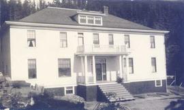
Photograph depicts a multi-level home with chopped wood in the foreground and a forested area in the background. Annotation on verso of photograph states: "Kitamaat Girls Home"
Photograph depicts four women on the front porch of a multi-level home. Annotation on verso of photograph states: "Kitamaat E.L.M. Home"
Image depicts numerous totem poles in Kispiox, B.C.
Image depicts a totem pole beside the grave marker of the Chief Lu-dal-da-zuatz, in Kispiox, B.C.
Image depicts an old house in Kispiox, B.C.
Image depicts an old, partially burnt totem pole in Kispiox, B.C.
The item is a photograph depicting a plaque where the Kinney house was located at 2249 Queensway Street, South Fort George. The plaque contains a photograph of Fannie Kinney and her house as well as a write up describing the house's history.
The item is a photograph negative depicting the front of the Kinney house at 2249 Queensway Street, South Fort George. The negative is from before 1985, as that is the year the house burnt down.
Image depicts the King George V School in Prince George, which was demolished sometime around 2006 and Duchess Park Secondary School was built in its place.
Photograph depicts a young man standing between two young women in front of three-story elementary school in Prince George, B.C. Power lines, buildings, and trees on hillside in background. Handwritten annotation on recto of photograph: "Em Joyce + Barb."
Image depicts a woman walking along a trail somewhere in Kettle Valley, B.C.
Image depicts a view of Kettle Valley, with a bridge of the old Kettle Valley Rail Road visible on a slope.
Image depicts a woman walking along the trail of the Kettle Valley Rail Road.
Image depicts the trail of the old Kettle Valley Rail Road.
Image depicts a man standing on the old Kettle Valley Rail Road.
Image depicts the old Kettle Valley Rail Road.
Image depicts several unknown individuals standing on the old Kettle Valley Rail Road.
Image depicts the Okanagan Kettle Valley, with the Kettle Rail Road faintly visible among the trees
Image depicts the trail of the old Kettle Valley Rail Road.
Image depicts a woman standing on the old Kettle Valley Rail Road.
Image depicts the Harrison House in Kersley, B.C.
Image depicts a log house located somewhere on Kerry Street in Prince George, B.C.
Image depicts Kent Sedgwick standing on the other side of a log bridge in a forest somewhere on Haida Gwaii.
Photograph depicting Kent Sedgwick and a dog in someone's garden and personal residence.
Image depicts Kent Sedgwick sitting on the bank of a river. An old beehive burner is visible in the background. Located somewhere in or near Penny, B.C.
Image depicts a boat dock on the Nechako Reservoir at Kenny Dam.
Image depicts a boat on the Nechako Reservoir at Kenny Dam.
Image depicts the Kenney Dam near Cheslatta, B.C.
Image depicts Kelly Lake Ranch
Image depicts a sign on the dirt road leading to Barkerville from Keithley Creek. The sign reads: "Barkerville 40 (via Yanks Peak) Maximum elevation 6200 FT. Summer road only. Steep grades and switchbacks not recommended for other than 4-wheel drive vehicles. You are entering an isolated mountain area; you will be on your own."
Photograph depicts the Kaslo city hall built in 1898.
Photograph depicts the Kaslo City Hall, built in 1898. The first floor contained a library while the second floor held a coutroom with original furnishings in mild disarray.
Image depicts the old Kamloops Residential School which operated until either 1977 or 1978 before becoming part of the Secwepemc Musem in 1982.
Two carved poles stand in front of a wide wooden building. Forest in background.
Printed below image: "OLD KAGAAN TOTEMS, KETCHIKAN, ALASKA".
Photograph depicts Kach Indian church.
Image depicts a junk pile of bottles, cans and bags, as well as the gutted frame of an old car, at Island Cache.
Photograph depicts the junction of Robson and Cordero St. in west end Vancouver, B.C. The photo is looking northwest on the newly demolished block, except for some houses at far end. View is looking down Robson St., with Cordero St. intersecting the photo.
Photograph depicts the joint CPR and CN depot at Vernon. The depot office had three employees working inside. Vernon is at mile 46.2 from Sicamous, on the Okanagan Subdivision of the CPR. It has daily way freight.
Photograph depicts a young woman believed to A.K. Bourchier's niece Jean. Young colt stands on right, picket fence and porch to wood building in background. Handwritten annotation on recto of photograph: "To my dearest Uncle Alan. This is little Betty Beauty's little colt. I broke her in to lead myself so I feel quite proud."