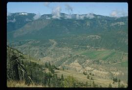
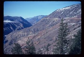
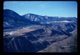
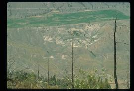
Photograph depicts the mine road in valley below bulldozer parked on edge of mountain. Cassiar plant and town visible in distance, south mountains behind them in background. Photo also depicts what appears to be a cloud rising from the tailings pile in plantsite.
Photograph depicts view of mine road in valley, from mountain above. Plant, tailings pile, and town visible in distance. South mountains in background. Handwritten annotation on verso of photograph: "1961", on recto: Townsite and Plantsite from mine."
Photograph depicts the mine road in valley, view from mountain above. Plant, tailings pile, and town visible in distance. South mountains in background. Handwritten annotation on recto of photograph: "1961-1962".
Photograph depicts the Cassiar mine above valley bellow, north east mountain range in background. Photograph was taken from the air, portion of plane visible in top left of image.
Photograph depicts the mine valley in foreground below Cassiar Mine, north east mountain range in background.
Photograph depicts the Cassiar mine in foreground, north east mountain range in background. Tramline station and crushing plant visible in foreground in front of pit. Photograph was taken from the air, portion of plane visible in top left of image.
Photograph depicts the Cassiar mine in foreground, north east mountain range in background. Tramline station and crushing plant visible in foreground, west of pit. Photograph was taken from the air, portion of plane visible in top left of image.
Photograph depicts the Cassiar mine above valley, north mountain range in background. Tramline station and crushing plant visible to west of pit. Photograph was taken from the air, portion of plane visible in top left of image.
Photograph depicts lumber piles and what appears to be a very long sluicing trough along Otter Creek. Forest and hills in background. Handwritten annotation on verso of photograph: "Otter Creek 6/6/37". See also item 2009.5.2.70.
Photograph depicts three men panning in stream, sluiceway behind them. Rocky banks in foreground, forest in background.
Handwritten annotation on verso reads: “Iona in Queen Charlotte City, August 1977”.
Photograph depicts mist from a wave rising above the stern of a weather ship.
Image depicts the Mist Glacier on the slope of Mt. Robson.
Image depicts the remains of the old Miworth Ferry, somewhere near Miworth, B.C.
Image depicts two unknown individuals and the remains of the old Miworth Ferry, somewhere near Miworth, B.C.
Image depicts four unknown individuals and the remains of the old Miworth Ferry, somewhere near Miworth, B.C.
Image depicts five unknown individuals sitting on the remains of the old Miworth Ferry, somewhere near Miworth, B.C.
Image depicts four unknown individuals and the remains of the old Miworth Ferry, somewhere near Miworth, B.C.
Image depicts the remains of the old Miworth Ferry, somewhere near Miworth, B.C.
Image depicts four unknown individuals and the remains of the old Miworth Ferry, somewhere near Miworth, B.C.
Photograph depicts the shore of Moberly Lake with leafy trees in the foreground.
Image depicts an obstructed view of Moberly Lake, located north of Chetwynd and south of Hudson's Hope, B.C.
Image depicts a delta at Moberly Lake north of Chetwynd and south of Hudson's Hope, B.C.
Photograph depicts colour-coded model of mine in display case. Legend partially legible in image: "TALUS / VOLCANICS / WASTE SERPENTINE / AAA ORE / AA ORE". Handwritten annotation on recto of photograph: "Cassiar B.C. June 1970 by Tom Kiefer".
Handwritten caption above this photo reads: "Ned got a Moose" (see also item 2005.3.65). Photograph depicts the head of a bull moose protruding from the fender of a car. Buildings and trees in background.
Photograph depicts Moran seated to right of woman on bench in foreground. Waterfall area at Moricetown Canyon can be seen below, behind booth labeled "MONITER BOOTH". Highway and houses visible on opposite shore in background.
Image depicts the Fraser River running through the Moran Canyon near Lillooet, B.C.
Image depicts a view of Moran Canyon in the Lillooet area. The Fraser River is visible on the left.
Image depicts the Fraser River running through the Moran Canyon near Lillooet, B.C.
Image depicts a view of Moran Canyon in the Lillooet area.
Image depicts the Fraser River running through the Moran Canyon near Lillooet, B.C.
Image depicts the Moran Canyon near Lillooet, B.C.
Image depicts what is possibly the Fraser River running through the Moran Canyon near Lillooet, B.C.
Image depicts the Moran Canyon; the Fraser River is visible near the bottom.
Image depicts an old earth flow in Moran Canyon, somewhere in the Lillooet area.
Image depicts a few old buildings, as well as several unknown individuals somewhere in Moricetown, B.C.
Image depicts a church on a hill in Moricetown, B.C.
Image depicts the Bulkley River running through Moricetown Canyon.