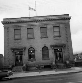
Print preview Close

Showing 4197 results

Archival description
3212 results with digital objects Show results with digital objects
Prince George
2012.13.1.3.046 · Item · Jan. 1978
Part of J. Kent Sedgwick fonds

Image depicts a view of Prince George from City Hall looking northeast along George Street. Map coordinates 53°54'46.3"N 122°44'41.9"W

Prince George
2012.13.1.3.077 · Item · May 1984
Part of J. Kent Sedgwick fonds

Image depicts downtown Prince George looking northwest. Map coordinates 53°54'48.7"N 122°44'45.6"W

Prince George
2012.13.1.3.078 · Item · May 1984
Part of J. Kent Sedgwick fonds

Image depicts a view of Prince George from City Hall looking northeast along George Street. Map coordinates 53°54'46.3"N 122°44'41.9"W

Prince George
2012.13.1.3.135 · Item · 12 Oct. 1989
Part of J. Kent Sedgwick fonds

Image depicts Prince George, possibly with the Northwood Pulpmill in the background.

Prince George
2012.13.1.3.133 · Item · 12 Oct. 1989
Part of J. Kent Sedgwick fonds

Image depicts Prince George, possibly with the Northwood Pulpmill in the background.

Prince George
2012.13.1.3.169 · Item · Mar. 2003
Part of J. Kent Sedgwick fonds

Image depicts an aerial view of what is possibly an outlying area of Prince George, B.C.

Prince George
2012.13.1.3.042 · Item · Nov. 1977
Part of J. Kent Sedgwick fonds

Image depicts downtown Prince George looking northwest across Dominion Street. Map coordinates 53°54'48.7"N 122°44'45.6"W

Prince George
2012.13.1.3.134 · Item · 12 Oct. 1989
Part of J. Kent Sedgwick fonds

Image depicts Prince George, possibly with the Northwood Pulpmill in the background.

Pouring Ribs at Crusher Site
2000.1.1.2.03.02 · Item · 29 June 1964
Part of Cassiar Asbestos Corporation Ltd. fonds

Handwritten annotation on recto of photograph: "POURING RIBS JUNE 29/64." Photograph depicts construction workers on large wooden framework structure extending from base of crusher building. Ladders stand parallel to structure against mountainside. The boom of a crane is visible in foreground. Miscellaneous construction equipment and materials throughout.

2000.1.1.2.03.03 · Item · 4 July 1964
Part of Cassiar Asbestos Corporation Ltd. fonds

Handwritten annotation on recto of photograph: "POURING FOOTING RETAINING WALL JULY 4/64." Photograph depicts construction workers manually pouring cement into forms laid against mountain wall on high elevation of construction site. Cement is being transported by wheelbarrow. A retaining structure made with wood planks and rebar separates mountainside dirt from cement forms. A bulldozer can be seen in background, as well as a front end loader and back hoe tractor. Building at crusher site also in background.

2000.1.1.2.04.05 · Item · [ca. 1970]
Part of Cassiar Asbestos Corporation Ltd. fonds

Photograph depicts large square model of the new mill building that was built at the Cassiar plant site in 1970. Model is displayed on platform draped with green material. Machinery modeled inside the structure is colour-coded.

Pool Hall
2012.13.1.37.36 · Item · [1980?]
Part of J. Kent Sedgwick fonds

Image depicts an old pool hall, crowded with unknown individuals, somewhere in Wells, B.C.

Police Barracks at Mile 47
2009.5.3.49 · Item · 1911
Part of Taylor-Baxter Family Photograph Collection

Photograph depicts three men wearing semi-formal attire at doorway to log building, miscellaneous supplies leaning against base of building. Dirt road in foreground, forest trees on hillside in background. Handwritten annotation on verso of photograph reads: "Mile 47 B.C. Police Barracks.", on recto of photograph: "Summit of Yellowhead pass and east boundary of British Columbia Mile 0. 699 miles to Prince Rupert. Tete Jaune Mile 52. Mile 47 east of Tete Jaune in the Park.", "1911".