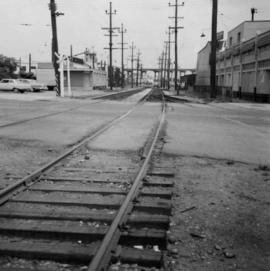
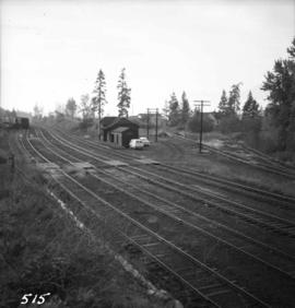
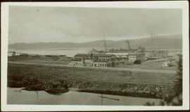
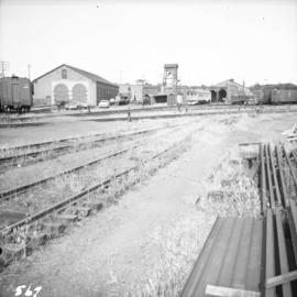
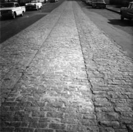
Photograph depicts the site of former single tram tracks going east up Frances St., near Commercial Dr., in east Vancouver, BC
Photograph depicts the site of the former Marpole inter-urban depot, looking east.
Photograph depicts the site of the first tramway in BC that ran between Anderson Lake and Seton Lake for 1 1/4 miles and was built in 1861. It lasted for 2 years and used wooden rails. The visible piece of track bed was 70 paces southwest of the PGE depot in Seton Portage. Parts of it had been obliterated by bulldozing that took place in the centre of the village.
Photograph depicts the site of the first tramway in B.C., that ran between Anderson Lake and Seton Lake for 1 1/4 miles and was built in 1861. It is located 70 paces southwest of what is now the PGE Seton Portage depot. It was opened for trafic in July 1861 and had lasted for two years.
Photograph taken at the Northwood Pulp and Timber Ltd, Prince George. Visible is a General Motors switcher, built in 1959. Aqcuired in 1981. Its sister locomotive had just returned from some major servicing at CN shops in P.G. Built in 1954 and acquired in 1989. Would not be used until business picked up. Pulp trade in world doldrums at the time the photograph was taken.
Photograph depicts Sirdar station belonging to the C.P.R. It is at the south end of Kootenay Lake and 11 miles north of Creston. There is a little used turntable behind the depot. The view is looking south.
Image depicts railway tracks and buildings with a beehive burner on the left. The location is likely Sinclair Mills, B.C. Map coordinates 54°01'17.4"N 121°40'53.0"W
Photograph depicts the Sinclair Mills community hall, it includes a sign in front of the building reading "Welcome to Sinclair Mills, Community Hall".
Photograph depicts a sign reading "Penticton East" beside a hut in the Penticton CPR depot yard.
Side view photograph of a small harbor close by a shoreline littered in organic debris. A foggy mountain range is visible in the background. Annotation on recto reads: "Wharf and Harbor Prince Rupert. May 1908 JDA."
Image depicts a vehicled parked on the side of the road, with a view of the coast of Haida Gwaii in the background.
Postcard depicts Sicamous Station and Hotel, circa 1910. "Sicamous became a favorite statring point for fishermen to the Shuswap Lake and junction for the fruit growing Okanagan Valley. The first station in Sicamous, built in 1890, burned down in 1900. A new one was built, modernized in 1908, and torn down in the 1960s."
Postcard depicts Sicamous Hotel. Original built in 1898, but belived to have been burned down in 1908.
Photograph depicts shovel loading Wabco haul truck on right. A second haul truck and an unidentified vehicle can be seen on far left. Handwritten annotation on recto of photograph: "Cassiar BC / June 1970 / 1400 on 6200 level / by T Kiefer".
Photograph depicts cable-operated shovel loading Kenworth haul truck on road in mine area at high elevation. Pickup truck in background, four unidentified men are gathered around second Kenworth truck in foreground. Valley and mountain range in distance.
Photograph depicts cable-operated shovel loading two Kenworth haul trucks on road in mine area at high elevation. Three unidentified men are gathered around truck in foreground. Valley and mountain range in distance.
Photograph depicts shovel loading Kenworth haul truck in mine. Unknown man stands on left, mountain range in background.
Photograph depicts what Davies noted to be a rare sight, short lengths of rail.
View of ripples in lake. Forest on opposite shore is reflected in water. It is believed this photograph was taken at Summit Lake, B.C.
Shops stand along riverside boardwalk. Storefront sign for R. Cunningham & Sons visible. Many people stand and sit on boardwalk, and canoes and small boats float in water in foreground.
Handwritten photo captions beside image read: "R. Cunningham & Sons - Probably Port Essington", "NW coast canoe".
Image depicts several ships on the water in Prince Rupert, B.C.
Photograph is a printed postcard depicting 2 ships at a dock with snow capped mountains in the background near Stewart B.C.
Photograph depicts the ship the "Princess of Vancouver" emerging westwards from the First Narrows in Vancouver.
Photograph depicts the ship the "Princess of Vancouver" passing Lions Gate Bridge in Vancouver, outward bound.
Photograph depicts the ship the "Princess of Vancouver" outward bound at midday. It is passing below the Lions Gate Bridge in Vancouver.
Photograph depicts the ship the "Princess Louise" under tow at about 7:30 pm, passing Brockton Point in Vancouver Harbour.
Photograph depicts the ship the "Princess Louise" under tow and just passed under the Lions Gate Bridge in Vancouver.
Photograph depicts the ship the "Princess Louise" under tow by the Vancouver tug "la Pointe", just west of the First Narrows.
Photograph depicts the ship the "Princess Louise" under tow by the Vancouver tug "La Pointe", going through the First Narrows. Just before going through the current took her at 45 degrees to the course and for a moment it looked as if she might run aground.
Photograph depicts the ship the "Princess Louise" at Lynn Terminals in Vancouver Harbour before departure for California. It has one poorly applied coat of white paint. The anchors have been removed and the towing tackle placed in position.
Photograph depicts the ship the "Princess Louise" at Lynn Terminals in Vancouver Harbour.
Photograph depicts the ship the "Princess Louise" prior to departure at Lynn Terminals, North Vancouver. She had been tied to this wharf for at least 18 months.
Photograph depicts a ship named "Pacific Northwest", possibly docked in either English Bay or Howe Sound.
Photograph depicts a large ship behind dock buildings. Railroad crosses foreground, hills visible on shore in background.
Handwritten annotation on verso reads: "Pr. Rupert Drydock".
Photograph depicts a large ship behind dock buildings. Railroad crosses foreground, hills visible on shore in background.
Handwritten annotation on verso reads: "Ship in Pr. Rupert dry dock during Great War 1915?".
Photograph depicts five First Nations children and a ship captain on the deck of the M.S. Columbia. Stamped annotation on recto states: “Oct – 64”
Photograph depicts a steamship "Camosun" in water with mountains in the background. Possibly near Stewart B.C.
Photograph depicts a ship the "Laurier", which may have been a Fisheries Protection Vessel, at the Federal Immigration Dock in Vancouver.
Photograph depicts a ship at Schwartz Bay on Vancouver Island. The ship's name begins with the "Queen of".
Photograph depicts a large ship behind dock buildings. Railroad crosses foreground, hills visible on shore in background.
Handwritten annotation on verso reads: "Drydock Prince Rupert".
Photograph depicts sheds and repair center of the C.P.R. at Victoria, near Lime Bay. The rail-liner just came in from the daily run to Courtenay.
Photograph depicts a privately owned preserved shed that was in good shape considering it was not part of any scheme. It was found beside a water tower.
Photograph depicts the boiler side of Shay locomotive #115 at the car tippler. It is located at the Pacific Coast Bulk Terminals in North Vancouver.
Photograph depicts Shay #115 locomotive at the Pacific Coast Bulk Terminals in North Vancouver. The engineer on locie is J.B. Kay, 4127 Yale St., in north Burnaby. He was a logging railway engineer in 20s and 30s, and then later on main line.
Photograph depicts Shay #115 engine at work at the Pacific Coast Terminals in North Vancouver.
Photograph depicts a Shay #1 locomotive on display at the Cowichan Valley Forest Museum. It was built by Lima in December 1920. It is a 2 truck with a length of 31'6", width of 8', and a height of 12'8". It has a 50" wheel base or a total of 20 1/2', and a wheel diameter of 27". The boiler pressure is 160 lbs. and the water capacity is 500 gallons. The weight is 26 tons.
Photograph depicts a Shay #1 locomotive on display at the Cowichan Valley Forest Museum. It was owned by the Hillcrest Lumber Ltd. in Honeymoon Bay, all of its working life from 1920-1962. It was originally built for a 3' gauge but then was converted to a 4' 8 1/2" by Hillcrest, and then reverted to the original size by Hillcrest for the Museum.
Photograph depicts tree shadows halfway up the steep slope of man-made embankment, forest in background. Tracks made my machinery are visible in dirt of the cut.
Photograph depicts several people aboard a sailboat on the water with a forested shoreline in the background.