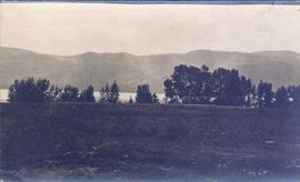
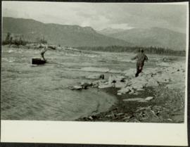
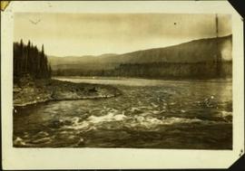
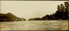
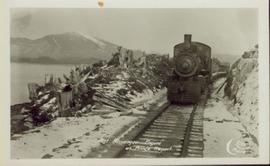
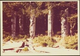
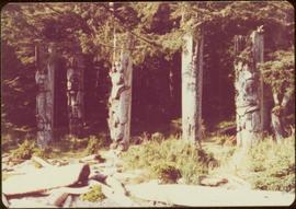
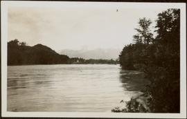
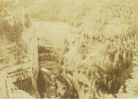
Image depicts the Fraser River, likely near the Hansard railroad bridge.
Photograph depicts a landscape shot of a grassy field overlooking a forested shoreline with mountains in the background.
Photograph depicts fields recently cleared from virgin bush on Miracle Breach on Vancouver Island.
Image depicts numerous skiers standing near a finish line somewhere on Tabor Mountain in Prince George, B.C.
Photograph depicts a man standing in a small canoe, facing a second man walking along the shore. Hills on opposite shore in background. Handwritten annotation on recto of photograph: "Finlay Rapids. Peace River."
Handwritten caption below this photo reads: "Finlay River Rapids. - 1930."
A small peninsula extends into river in left midground, rapids in foreground, trees and hills on opposite shore in background.
Image depicts a snow sculpted fire place and couch on a skating rink, possibly during the Winter City Conference, in Prince George, B.C. Taken at the Prince George Civic Center. Map coordinates 53°54'45.6"N 122°44'59.6"W
Photograph depicts buildings on shore in background, hills visible in distance.
Handwritten annotation on verso reads: "1st canyon Nass River".
Image depicts a faded First Nations' rock painting.
Image depicts an unknown woman pointing towards some faded First Nations' rock paintings.
Head on shot of steam engine traveling through a pass with mountains in the background. Handwritten annotation in pen on verso reads: "First Passenger Engine to reach Prince Rupert." Annotation on recto reads: "First Passenger Engine at Prince Rupert." Photographer' stamp in bottom right corner of recto reads : "Allen Photo."
Photograph of a team of sled dogs resting while a group of people rest around them. Printed annotation on recto reads: "First White Woman to Cross to the Naas #97."
Image depicts numerous boats docked by a buildings identified as the "Prince Rupert Fishermen's Co-operative Association."
Image depicts two youths fishing from the bank of the Nechako River on Cottonwood Island.
Image depicts a few unidentified individuals fishing in a river at an uncertain location.
Typed annotation on recto: "Fishing Stuart Lake B.C." Two men and one woman stand on boat with fishing gear, and a rainbow trout caught in net. Trees on hill in background. It is believed that Mr. and Mrs. Factor are present on the boat (see item 2004.6.28).
Image depicts two individuals fishing in a canoe on McCleary Lake. The slide is also labelled "dolly," likely meaning the fish in the net is a Dolly Varden trout.
Forest in background, wooden logs lie in foreground.
Photograph is one of 13 images printed from digital format on a CD-R featuring members of a group referred to as 'Terracites' (see item 2009.6.1.697) pictured in the gardens; see also items 2009.6.1.698 - 2009.6.1.710.
Forest in background, wooden logs lie in foreground.
Image depicts five unknown individuals somewhere near Mt. Robson.
Image depicts some power lines and a forest somewhere near Birken, B.C.
Image depicts numerous tree logs floating on a body of water. The location is uncertain, but is likely Eaglet Lake.
Image depicts a flooded area with an old sawdust pile in the background. Likely near McGregor, B.C.
Photograph depicts lane in front of tent buildings flooded with water, forest trees in background. Photograph taken from canoe, portion of canoe visible in foreground. It is believed that this photograph may depict the Island Cache in flood, at Prince George, BC.
Photograph depicts lane in front of tent buildings flooded with water. Tree in midground, forest trees in background. A man can be seen between first and second row of tent buildings. Photograph taken from canoe, portion of canoe visible in right foreground. It is believed that this photograph may depict the Island Cache in flood, at Prince George, BC.
Handwritten annotation on verso reads: "Nass River canyon at flood water". A building is visible on shore in distance, and mountains can be seen in background.
Photograph taken at Government House in Victoria, B.C.
Image depicts the Flying U Ranch at 70 Mile House, B.C.
Image depicts the foot of Indianpoint Lake.
Image depicts a camp at the foot of Isaac Lake.
Image depicts a narrow footbridge suspended over a river at an uncertain location.
Image depicts what appears to be a footbridge at an uncertain location.
Image depicts an esker at the Foothills Boulevard in Prince George, B.C.
Image depicts the Foothills Bridge over the Nechako river on the Foothills Boulevard in Prince George, B.C. Map coordinates 53°56'52.5"N 122°48'59.9"W
Photograph depicts an unidentified guide lying in the snow on top of a mountain peak searching for game through a pair of binoculars. In the foreground footprints in the snow are visible while the background features a snow-covered mountain range.
Image depicts a few unknown individuals walking through the forest at Cheslatta.
Image depicts a forest, possibly somewhere near Woodpecker, B.C.
Image depicts a forest somewhere on Haida Gwaii.
Image depicts a view of the forest in the Fort George Canyon Provincial Park, B.C.
Photograph depicts a forest along the edge of the striated and deeply cut banks of an unseen river at the base of the banks.
Item is a photograph of a forested area with a partially frozen river, exact location unknown.
Image depicts a view of a forest and river somewhere along the White Pass railway. The thin line in the mountain side is possibly a highway.