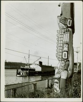
Photograph depicts a close-up of a totem pole behind a fence overlooking a wharf and a ship named Camosun. Photographer’s stamp on verso: “W.E. Nicholson, 268 E. 10th, Vancouver 10, B.C.”
Totem poles (crest poles?) stand in front of a line of houses. Blanketed canoes sit on beach in right foreground; forest in background.
Handwritten annotations on verso read: “Haida Encampment [crossed through with line]"; "Skidegate Queen Charlottes Islands / To illustrate Introduction / Introduction Trophies from a Song [Trail?] Page 1 Heading."
Forest and hills on opposite shore in background.
Handwritten annotation on verso reads: "poling canoe up Nass River".
Image depicts a camper passing under an overhang as it drives along a narrow road near a cliff; located somewhere near Bralorne, B.C.
Image depicts a camper parked on the side of a narrow road along a cliff as another car approaches; located somewhere near Bralorne, B.C.
Photograph depicts opposite shore in background behind river, and close shore in foreground on right. Men can be seen standing and paddling on canoe in distance. Handwritten photo caption on verso and recto of this photograph reads: "On the Clearwater".
Photograph depicts opposite shore in midground behind river, tree-covered hills in background. Handwritten photo caption on verso and recto of this photograph reads: "On the Clearwater".
Photograph depicts tree stumps in forest clearing of the railway right-of-way.
Photograph depicts stumps and log piles in forest clearing of the railway right-of-way.
Photograph depicts men walking among stumps and log piles in forest clearing of the railway right-of-way.
Photograph depicts smoke, stumps and log piles in forest clearing of the railway right-of-way.
Photograph depicts cleared area of forest, vehicle tracks visible in the mud, and a large dirt area in midground.
Image depicts a highway, and a section of mountain in the background which is bare due to clear-cut logging. It is possibly somewhere near Prince George, B.C.
Image depicts the Clayhurst Ferry on the Peace River.
Photograph depicts a clamshell dredge at work near a BCE Railway trestle. Its spurs were down, suggesting rip-rap dumping.
Photograph depicts a clamshell dredge at work beside a BCE Railway trestle. It appeared to be placing rip-rap.
Photograph depicts a clamshell dredge at work.
Photograph depicts the Chute depot at mile 106.5 on the CPR line in the Carmi Subdivision. It is a totally isolated location, but not reachable by road. The photo shows the only surviving large building. The rail here is dated 1942.
Photograph depicts a gondola converted to a chip car at the Creston CPR yard. It was built of converted in July 1953 and is car #343319. It was awaiting loading when the picture was taken.
Image depicts two children standing near an old car in Island Cache.
Photograph depicts a train of the Chicago, Rock Island and Pacific Railroad that had 7,800 miles in 1963.
Photograph depicts a Chevrolet army truck. It was last used in 1959 for towing purposes.
Image depicts a view of a train passing through an area of Chetwynd, B.C.
Image depicts a view of Chetwynd, possibly from Highway 97.
Photograph depicts locomotive #1044 of MacMillan Bloedel. It was removed from service in 1970 and placed subsequently on display. Built by H.K. Porter Company, Pittsburgh in 1924.
Photograph depicts a caboose on display oustide of the MacMillan Bloedel mill. The full display consisted of a locomotive, pole car, and this caboose.
Photograph depicts the top view of a locomotve on display adjacent to the MacMillan Bloedel mill. The rectangular tank behind the chimney was a home-made central water filling device leading to the 2 side tanks.
Photograph depicts part of the trackage of the MacMillan Bloedel mill between the mill and tidewater level. Visible is a disused and rotting water tank.
Photograph depicts a part of trackage owned by MacMillan Bloedel Ltd. which connects the mill on the upper or town level and the tidewater below it. This is the southward grade to the tidewater. Image taken from the upper branch at about half of a mile from the mill.
Photograph depicts locomotive #1044 on display outside the MacMillan Bloedel mill. The locomotive was built by H.K. Porter Company, Pittsburgh in 1924.
Photograph depicts a Pacific Great Eastern Railway wooden trestle in Cheakamus Canyon.
Photograph depicts a Pacific Great Eastern Railway wooden trestle in Cheakamus Canyon at 19 mile.
Photograph depicts a Pacific Great Eastern Railway wooden trestle in Cheakamus Canyon.
Photograph depicts four men standing near fully packed horse-drawn cart in front of wood buildings, including a long building with a porch and chairs. Trees on hill visible in background. Handwritten annotation on recto of photograph: "Changing teams on the Cariboo Road".
Left to right: Deborah Poff, Dennis Macknak, Charles Jago, an unidentified woman, Iona Campagnolo, an unidentified man, Ellen Facey, and an unidentified woman. Unknown man stands on lower deck in foreground. Mountains visible in background. Photograph taken during the Chancellor's 1996 regional tour through Atlin and Whitehorse; see also items 2009.6.1.578 - 2009.6.1.581.
Handwritten annotation on verso reads: "#3 Chancellor's Tour".
Left to right: Deborah Poff, Dennis Macknak, Charles Jago, an unidentified woman, Iona Campagnolo, Ellen Facey, Nick Petraryszak, an unidentified man, and an unidentified woman. Unknown man stands on lower deck in foreground. Mountains visible in background. Photograph taken during the Chancellor's 1996 regional tour through Atlin and Whitehorse; see also items 2009.6.1.578 - 2009.6.1.580.
Left to right: Chancellor Iona Campagnolo, Nick Petraryszak, Ellen Facey, unidentified woman and men. Mountains visible in background. Photograph taken during the Chancellor's 1996 regional tour through Atlin and Whitehorse; see also items 2009.6.1.578 - 2009.6.1.581.
Photograph depicts three men (two in uniform) in front of a military plane with the number "7632" on its side. Handwritten photo album caption below this photo reads: "OUR CENIAL CREW OF "32". It is believed this photograph was taken at the military base in Whitehorse, YT.
Royal Canadian Air ForcePhotograph depicts a Lafarge cement loading spur.
Photograph depicts a Lafarge cement loading spur.
Photograph depicts the C.C.G.S. "Vancouver" launched about two minutes previously and about 400 yards from Burrard Dry Dock in North Vancouver. The photograph was taken from the sailing dinghy "Ceiriog".
Photograph depicts large Caterpillar engine on flatbed. Road in foreground, trees in background. Accompanying note reads: "MTCE 4-01 (b) Cat 3612 Engine".
Photograph depicts large Caterpillar engine in large shop with sheeted walls and brick floor. Accompanying note reads: "MTCE 4-01 (b) Cat 3612 Engine".
Photograph depicts large Caterpillar engine against painted brick wall in building with brick floor. Miscellaneous equipment in background. Accompanying note reads: "MTCE 4-01 (b) Cat 3612 Engine".
Image depicts a truck parked on the side of the Cassiar Highway.
View of snow capped mountains in the distance, vast rolling treed hills in mid ground and a gravel road in the foreground. Road sign indicating severe curve in road situated at the right of the gravel road. Handwritten annotation on verso in pen reads: “Cassiar – Stewart highway”