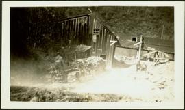
Photograph depicts the Cassiar mine. North and South peak featured in background, and West peak in left foreground. Pit is being developed between South peak and West peak. Old mine garage is visible in lower centre of image, and crushing plant in right foreground. Mountain range in distance.
Image depicts a view of the Millar Addition suburb in Prince George, B.C.
Overview of the Giscome sawmill behind road. Lumber yard is visible in foreground while mill stands in background.
Handwritten annotation in pencil on verso: "Giscome Mill / lumber yard in foreground".
Item is a photograph of a small mill operation.
Man driving a two horse cart in front of beehive burner, cart is full of bark presumably sawed off the logs.
Handwritten annotation in pencil on verso: "Mill Burner".
Image depicts numerous trees on the bank of a river, possibly in Miles Canyon near Whitehorse, Y.T. The slide is labelled "canyon city."
Image depicts numerous unidentified individuals getting off a boat which bears the name "Schwatka." It is located somewhere in Miles Canyon.
Image depicts the Robert Lowe Bridge, built in 1922, in the Miles Canyon near Whitehorse Y.T.
Image depicts several unidentified individuals on a boat in the Miles Canyon near Whitehorse Y.T.
Image depicts a river in the Miles Canyon near Whitehorse Y.T.
Image depicts a river in the Miles Canyon near Whitehorse Y.T. The Robert Lowe Bridge, built in 1922, can be seen over the canyon.
Image depicts a river at an uncertain location, but possibly in Miles Canyon near Whitehorse, Y.T.
Image depicts a stretch of land from Highway 97 at Mile 231, possibly near Clinton, B.C.
Image depicts the property of an old ranch at Mile 108 of Highway 97.
Image depicts Middle River by Trembleur Lake.
Annotation on slide: "Summit Lake M. Jull on skid road with advanced regen".
Annotation on slide: "Summit Lk., Mod. vol. removal".
No annotation on slide.
Annotation on slide: "Blowdown due to butt rot (tomentosus), Summit Lake".
Annotation on slide: "Basal scarring on Douglas fir, Summit Lake".
No annotation on slide.
Annotation on slide: "Light residual basal area, Summit Lake, Summer '92, Jull".
Image depicts the Meziadin Lake and the Bear Pass in the distance.
Image depicts the Meziadin Lake.
Image depicts the fish ladder of the Meziadin Falls, designed to help fish swim upstream.
Image depicts the Meziadin Falls in Meziadin Lake Provincial Park.
Image depicts several salmon somewhere in the Meziadin Lake Provincial Park.
Image depicts several individuals looking down into a closed off section of a river in Meziadin Lake Provincial Park. They are counting fish.
Image depicts buildings in the village community of Metlakatla, B.C.
Image depicts Metlakatla, located near Prince Rupert, B.C.
Image depicts buildings in the village community of Metlakatla, B.C.
Photograph depicts group of men working in unknown excavation area, possibly mining. Bushes in foreground, forest in background.
Photograph depicts three men standing with oars in small boat, forest slash at their feet. More slash lies in foreground behind bushes and plants on swampy shore. Trees in background. These men are believed to be members of the Bourchier forestry crew.
Photograph depicts two men and bulldozer near what appears to be many piles of logs. Unidentified buildings in background.
Photograph depicts two men working with air track drill in mine area. Hose and dynamite box in foreground, mountains in background. Handwritten annotation on verso of photograph: "Sept. 1954." This photograph was originally stored inside duotang labeled "CASSIAR ASBESTOS CORPORATION LIMITED PHOTOGRAPHS 1954"; photo caption beneath this image: "Starting New Bench at South end of Deposit."
Photograph depicts two unidentified men unloading pack boxes while Carrol Paul walks away to the left while holding a rifle. In the background horses are grazing beside a forested area.
Image depicts a house with torn-up siding. The slide is labelled: "Mellos house relocated from Penny." The location is uncertain.
Image depicts part of the McMillan Creek Trail in the McMillan Regional Park in Prince George, B.C.
Image depicts part of the McMillan Regional Park in Prince George, B.C.
Image depicts the McMillan Creek from Northwood Pulpmill Road, in Prince George, B.C.
Image depicts the McLeod River in Carp Lake Provincial Park.
Image depicts a building by the shore of McLeod Lake.
Image depicts McLeod Lake, with the view facing north-west.
Image depicts McLeod Lake.
Image depicts McLeod Lake and several buildings along the shore.
Image depicts McLeod lake.
Photograph depicts dry creek bed, tall banks on either side. Hills and lake cross midground, mountains visible in background. Handwritten annotation on verso of photograph: "Looking down McKee Creek across Atlin Lake Towards Taku Glacier 6/27/37."
Image depicts a dirt road and a densely forested treeline, possibly in the McGregor Valley.