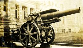
Photograph depicts a Krupp Morser 21 cm Howitzer on display near parliamentary buildings. This mortar was a Canadian war trophy from World War I, captured September 27, 1918 near Bourlon Wood. It was transported to Victoria on the CPR in July 1920. Handwritten annotation below photograph reads, "German gun at Victoria , BC".
Image depicts the historical village of 'Ksan near Hazelton, B.C.
Image depicts the 'Ksan historical village in Hazelton, B.C.
Image depicts the historical village of 'Ksan in Hazelton, B.C.
Image depicts a group of people in the historical village of 'Ksan near Hazelton, B.C.
Image depicts the entrance to the historical village of 'Ksan in Hazelton, B.C.
Image depicts a large gathering of people in the interior of a First Nations' longhouse located in the historical village of 'Ksan in Hazelton, B.C.
Image depicts a totem pole in the historical village of 'Ksan near Hazelton, B.C.
Photograph depicts man believed to be Matt Bell standing in Kutcho Creek exploration camp. The camp was set up by a crew led by Cassiar's Chief Geologist Bill Plumb. Tents on either side, wood structure in background. Sign on wood post: "PLUMB BLVD."
Photograph depicts valley in Kutcho Creek area, exploration camp in distance at foot of hill. The camp was set up by a crew led by Cassiar's Chief Geologist Bill Plumb.
Photograph depicts valley in Kutcho Creek area, exploration camp in distance. Body of water in foreground, mountains in background. The camp was set up by a crew led by Chief Geologist Bill Plumb.
Photograph depicts an exploration camp in the valley at the Kutcho Creek area in B.C. The camp was set up by a crew led by Cassiar's Chief Geologist Bill Plumb.
Photograph depicts the KVR depot in Brookmere.
Photograph taken at the KVR yard in Brookmere. Visible is a private section man's house. This was originally a joint Great Northern Railway (USA) and Canadian Pacific Railway facility. It had a roundhouse, turntable, water tower, etc. Helper engines for Coquihalla shedded here. Originally, there were 3 line of track here.
Photograph taken at the KVR station in Coalmont. It once had coal sidings for the nearby coal mine, but they had been removed. It also had passing siding for 33 cars. Now made inoperable.
Photograph depicts KVR (CPR) trackage between Boundary Falls and Midway. The line had not yet been officially abandoned, but it was little used, if not at all.
Photograph depicts a terminus of a boundary Subdivision on mile 126.6 from Nelson.
Photograph depicts a train that was reconditioned at the Forestry Museum in Duncan in 1995/6. At that location, Davies had seen its fire box being rebricked.
Photograph depicts 2 cars in use between Summerland and Trout Creek bridge.
Photograph depicts a car (at the left) which is an office and on display. The car on the right was operating equipment. Photograph taken at the KVR Historical Society headquarters.
Photograph depicts the inspection party at the end of their trip at the south end of the Klo Creek crossing. This is located at mile 86.55 on the Kettle Valley Railway in Myra Canyon, and is about 2.75 miles from Myra depot.
Photograph taken near the Manning Park KVR station. It was a passing point. Main track was on the left, siding with a capacity of 70 cars, on the right. In the 1980's, the siding housed boxed cars, etc., that were not in traffic use due to the recession that commenced in 1982.
Photograph depicts the KVR depot in Merritt. Operator's signal post still stood.
Photograph depicts the KVR depot in Merritt. Building on the right was a freight shed.
Photograph depicts the KVR depot in Merritt.
Photograph depicts the KVR yard in Merritt. The switch stand was ready for dispatch.
Photograph depicts the KVR yard in Merritt. On the Nicola spur/branch, looking west towards the KVR depot. Track on the left was part of a wye.
Photograph depicts a part of the KVR yard in Merritt. Looking southeasy, with main line to Penticton bearing away to the right. Jumble of of rails in the foreground was believed to be a rail storage pile.
Photograph depicts a train at the KVR Museum in Summerland.
Photograph depicts a train, labelled "Mayo Lumber," at the KVR Museum in Summerland.
Photograph depicts a locomotive car at the KVR Museum in Summerland.
Photograph depicts a train at the KVR Museum in Summerland.
Photograph depicts a train and two locomotive cars at the KVR Museum in Summerland.
Photograph depicts a train at the KVR Museum in Summerland.
Photograph taken looking east, towards the depot and town of Princeton. Behind the yard lay the beginnings of the former Copper Canyon branch.
Photograph depicts abandoned KVR track. The depot was located just behind the camera.
Photograph depicts the west yards of the KVR.
Photograph depicts a spur that led off on the norst side of the main line between Princeton and Brookmere. The last train seen here was in May, 1989.
Photograph depicts KVR track in Princeton.
Photograph taken in the KVR yard area where there was a ballon in the place of a turning wye.
Photograph depicts details of a switch stand.
Photograph taken looking west towards the depot in Princeton on mile 70.5.
Photograph depicts an open space where former yards of the KVR were located. Visible is a 2 stall engine shed, a turning ballon (in place of a wye), and the connection with the 14 long Copper Mountain Bracnch which conveyed copper concentrate and closed in 1957. Just out of view, on the right, was the Princeton Tunnel built by the GNR in 1910.
Photograph taken somewhere between Thalia and Manning. At this point, Davies caught up with dismantling crews of Pacific Northern Rail Contractors Ltd. Here, rails were removed, but ties were still in place.
Photograph taken east of the KVR depot in Merritt. Trackage on the left was a Nicola spur/branch. Track to the right was part of the main line to Princeton. The two connected behind the trees to form a turning a wye.